KH-9 Hexagon


KH-9 (BYEMAN codename HEXAGON), commonly known as Big Bird[1] or Keyhole-9, was a series of photographic reconnaissance satellites launched by the United States between 1971 and 1986. Of twenty launch attempts by the National Reconnaissance Office, all but one[2] were successful. Photographic film aboard the KH-9 was sent back to Earth in recoverable film return capsules for processing and interpretation. The best ground resolution achieved by the main cameras was better than 0.6 meters.[3]
They are also officially known as the Broad Coverage Photo Reconnaissance satellites (Code 467), built by Lockheed Corporation for the National Reconnaissance Office.[1]
The KH-9 was declassified in September 2011 and an example was put on public display,[4][5] for one day, on September 17, 2011, in the parking lot of the Steven F. Udvar-Hazy Center of the National Air and Space Museum, outside Dulles International Airport.[6][7]
On January 26, 2012 the National Museum of the United States Air Force put a KH-9 on public display along with its predecessors the KH-7 and KH-8.[8]
Development

The KH-9 was originally conceived in the early 1960s as a replacement for the Corona search satellites. The goal was to search large areas of the earth with a medium resolution camera. The KH-9 carried two main cameras, although a mapping camera was also carried on several missions. The photographic film from the cameras was sent to recoverable re-entry vehicles and returned to Earth, where the capsules were caught in mid-air by an aircraft. Four re-entry vehicles were carried on most missions, with a fifth added for missions that included a mapping camera.
Between September 1966 and July 1967, the contractors for the Hexagon subsystems were selected. LMSC was awarded the contract for the Satellite Basic Assembly (SBA), Perkin Elmer for the primary Sensor Subsystem (SS), McDonnell for the Reentry Vehicle (RV), RCA Astro-Electronics Division for the Film Take Up system, and Itek for the Stellar Index camera (SI). Integration and ground-testing of Satellite Vehicle 1 (SV-1) was completed in May 1971, and it was subsequently shipped to Vandenberg Air Force Base in a 70 ft container. Ultimately, four generations ("blocks") of KH-9 Hexagon reconnaissance satellites were developed. KH9-7 (1207) was the first to fly a Block-II panoramic camera and SBA. Block-III (vehicles 13 to 18) included upgrades to electrical distribution and batteries. Two added tanks with ullage control for the Orbit Adjust System (OAS) and new thrusters for the Reaction Control System (RCS) served to increase KH-9's operational lifetime. In addition the nitrogen supply for the film transport system and the camera vessel was increased. Block-IV was equipped with an extended command system using plated wire memory.[9] In the mid 1970s, over 1000 people in the Danbury, Connecticut area worked on the secret project.[10]
A reentry vehicle from the first Hexagon satellite sank to 16,000 feet below the Pacific Ocean after its parachute failed. The USS Trieste II (DSV-1) retrieved its payload in April 1972 after a lengthy search but the film disintegrated due to the nine months underwater, leaving no usable photographs.[11]
Over the duration of the program the lifetime of the individual satellites increased steadily. The final KH-9 operated for up to 275 days. Different versions of the satellite varied in mass; most weighed 11,400 kg or 13,300 kg.
Main camera


The main camera system was designed by Perkin-Elmer[12] to take stereo images, with a forward looking camera on the port side, and an aft looking camera on the starboard side. Images were taken at altitudes ranging from 90 to 200 miles. The camera optical layout is an f/3.0 folded Wright Camera, with a focal length of 60 in (1.5 m). The system aperture is defined by a 20 in (0.51 m) diameter aspheric corrector plate, which corrects the spherical aberration of the Wright design. In each of the cameras the ground image passes through the corrector plate to a 45 degree angle flat mirror, which reflects the light to a 0.91 m (36 in) diameter concave main mirror. The main mirror directs the light through an opening in the flat mirror and through a four-element lens system onto the film platen. The cameras could scan contiguous areas up to 120 degree wide, and achieved a ground resolution better than 2 ft (0.61 m) during the later phase of the project.[3][13]
Mapping imagery
Missions 1205 to 1216 carried a "mapping camera" (also known as a "frame camera") that used 9 inch film and had a moderately low resolution of initially 30 ft (9 m), which improved to 20 ft (6 m) on later missions[14] (somewhat better than LANDSAT). Intended for mapmaking, photos this camera took cover essentially the entire Earth with at least some images between 1973 and 1980.[15] Almost all the imagery from this camera, amounting to 29,000 images, each covering 3400 square km, was declassified in 2002 as a result of Executive order 12951,[16] the same order which declassified CORONA, and copies of the films were transferred to the U.S. Geological Survey's Earth Resources Observation Systems office. Images from the mapping camera covering the state of Israel and all imagery from the KH-9's other cameras remain classified.[17]
The KH-9 was never a backup project for the KH-10 Manned Orbital Laboratory. It was developed solely as a replacement for the Corona search system.
High-altitude atmospheric density
Missions 1205 to 1207 carried Doppler beacons[18] to help map the atmospheric density at high altitudes in an effort to understand the effect on ephemeris predictions.[19][20] The measurements of the atmospheric density were released through NASA.[21]
ELINT subsatellites
Missions 1203, 1207, 1208, 1209, and 1212 to 1219 included Ferret ELINT subsatellites, which were launched into a high earth orbit to catalogue Soviet air defence radars, eavesdrop on voice communications, and tape missile and satellite telemetry. Missions 1210 to 1212 also included scientific subsatellites.[22][23][24][25][26][27][28][29][30]
KH-9 missions
| Name | Block[9] | Mission no. | Launch date | NSSDC ID NORAD # |
Other Name | Launch vehicle | Orbit | Decay date |
|---|---|---|---|---|---|---|---|---|
| KH9-1 | I | 1201 | 1971 June 15 | 1971-056A[31] 05297 |
OPS 7809 | Titan IIID | 184.0 km × 300.0 km, i=96.4° | 1971 Aug 06[32] |
| KH9-2 | I | 1202 | 1972 Jan 20 | 1972-002A[33] 05769 |
OPS 1737 | Titan IIID | 157.0 km × 331.0 km, i=97.0° | 1972 Feb 29[34] |
| KH9-3 | I | 1203 | 1972 Jul 7 | 1972-052A[35] 06094 |
OPS 7293 | Titan IIID | 174.0 km × 251.0 km, i=96.9° | 1972 Sep 13[36] |
| KH9-4 | I | 1204 | 1972 Oct 10 | 1972-079A[37] 06227 |
OPS 8314 | Titan IIID | 160.0 km × 281.0 km, i=96.5° | 1973 Jan 08[38] |
| KH9-5 | I | 1205 | 1973 Mar 9 | 1973-014A[39] 06382 |
OPS 8410 | Titan IIID | 152.0 km × 270.0 km, i=95.7° | 1973 May 19[40] |
| KH9-6 | I | 1206 | 1973 Jul 13 | 1973-046A[41] 06727 |
OPS 8261 | Titan IIID | 156.0 km × 269.0 km, i=96.2° | 1973 Oct 12[42] |
| KH9-7 | II | 1207 | 1973 Nov 10 | 1973-088A[43] 06928 |
OPS 6630 | Titan IIID | 159.0 km × 275.0 km, i=96.9° | 1974 Mar 13[44] |
| KH9-8 | II | 1208 | 1974 Apr 10 | 1974-020A[45] 07242 |
OPS 6245 | Titan IIID | 153.0 km × 285.0 km, i=94.5° | 1974 Jul 28[46] |
| KH9-9 | II | 1209 | 1974 Oct 29 | 1974-085A[47] 07495 |
OPS 7122 | Titan IIID | 162.0 km × 271.0 km, i=96.7° | 1975 Mar 19[48] |
| KH9-10 | II | 1210 | 1975 Jun 8 | 1975-051A[49] 07918 |
OPS 6381 | Titan IIID | 157.0 km × 234.0 km, i=96.3° | 1975 Nov 05[50] |
| KH9-11 | II | 1211 | 1975 Dec 4 | 1975-114A[51] 08467 |
OPS 4428 | Titan IIID | 157.0 km × 234.0 km, i=96.7° | 1976 Apr 01[52] |
| KH9-12 | II | 1212 | 1976 Jul 8 | 1976-065A[53] 09006 |
OPS 4699 | Titan IIID | 159.0 km × 242.0 km, i=97.0° | 1976 Dec 13[54] |
| KH9-13 | III | 1213 | 1977 Jun 27 | 1977-056A[55] 10111 |
OPS 4800 | Titan IIID | 155.0 km × 239.0 km, i=97.0° | 1977 Dec 23[56] |
| KH9-14 | III | 1214 | 1978 Mar 16 | 1978-029A[57] 10733 |
OPS 0460 | Titan IIID | 172.0 km × 218.0 km, i=96.4° | 1978 Sep 11[58] |
| KH9-15 | III | 1215 | 1979 Mar 16 | 1979-025A[59] 11305 |
OPS 3854 | Titan IIID | 177.0 km × 256.0 km, i=96.3° | 1979 Sep 22[60] |
| KH9-16 | III | 1216 | 1980 Jun 18 | 1980-052A[61] 11850 |
OPS 3123 | Titan IIID | 169.0 km × 265.0 km, i=96.5° | 1981 Mar 06[62] |
| KH9-17 | III | 1217 | 1982 May 11 | 1982-041A[63] 13170 |
OPS 5642 | Titan IIID | 177.0 km × 262.0 km, i=96.4° | 1982 Dec 05[64] |
| KH9-18 | III | 1218 | 1983 Jun 20 | 1983-060A[65] 14137 |
OPS 0721 | Titan 34D | 163.0 km × 224.0 km, i=96.4° | 1984 Mar 21[66] |
| KH9-19 | IV | 1219 | 1984 Jun 25 | 1984-065A[67] 15063 |
USA 2 | Titan 34D | 170.0 km × 230.0 km, i=96.5° | 1984 Oct 18[68] |
| KH9-20 | IV | 1220 | 1986 Apr 18 | 1986-F03 | launch failed[2] | Titan 34D | — | — |
(NSSDC ID Numbers: See COSPAR)
Cost
The total cost of the 20 flight KH-9 program from FY1966 to FY1986 was US$3.262 billion in respective year dollars.[9]
Specifications
Data source: The Encyclopedia of US Spacecraft[1] and NSSDC
- Launch vehicle: Titan IIID/34D
- Total weight: 11,400 kg (25,100 lb), with mapping camera 13,300 kg (29,300 lb)
- Reentry weight: 5,330 kg (11,750 lb)[69]
- Max. diameter (main body): 3.05 m (120 in)[69]
- Length (with mapping camera): 16.21 m (638 in)[69]
- Orbit: elliptical, 100 miles by 150 miles
- Scanners: television, radio, and high resolution camera
Gallery
 The reaction control system of a KH-9, showing the propellant tanks.
 A KH-9 in scaffolding, being prepared for launch.
 A technician despools one of the re-entry modules which contained the film used by the cameras.
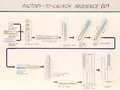 A diagram showing the assembly, testing and launch preparations of a KH-9.
 The forward section of a KH-9.
 A KH-9 re-entry module hanging from its parachute, ready to be retrieved.
 Another view of the KH-9's reaction control system.
 A KH-9 being transported by truck in a special canister.
 The shroud and base of a KH-9 undergo vibration tests in an acoustic chamber.
 This painting of a KH-9 shows the two different camera types that the satellite carried.
- Basic specifications and diagram of the KH-9.
- A KH-9 being raised vertically during its assembly.
 This diagram shows the various sections of the KH-9 and their dimensions.
See also
Other U.S. imaging spy satellites:
- Corona series:
- KH-5 ARGON
- KH-6 LANYARD
- KH-7 and KH-8 GAMBIT
- Manned Orbiting Laboratory (KH-10)
- KH-11
- KH-13
References
- 1 2 3 Yenne, Bill (1985). The Encyclopedia of US Spacecraft. Exeter Books (A Bison Book), New York. ISBN 0-671-07580-2.p.32 Big Bird
- 1 2 https://www.youtube.com/watch?v=XXBl03wVHOY
- 1 2 Gerald K. Haines (1997). "Critical to US Security: the development of the GAMBIT and HEXAGON satellite reconnaissance system". National Reconnaissance Office.
- ↑ https://fas.org/blogs/secrecy/2011/09/nro_50th/
- ↑ http://www.space.com/12996-secret-spy-satellites-declassified-nro.html
- ↑ Doyle, John M., Big Bird, uncaged, Air and Space, December 2011/January 2012, p.10
- ↑ Mail Online: Top secret surveillance satellite Big Bird, which took pictures of Soviet Union during Cold War, goes on public viewing, By Laurie Whitwell UPDATED: 16:33 EST, 17 September 2011
- ↑ Cohen, Aubrey, "Three former spy satellites go on display", Seattle Post-Intelligencer, Thursday, January 26, 2012
- 1 2 3 "The HEXAGON story" (PDF). National Reconnaissance Office. 1988.
- ↑ Decades Later, a Cold War Secret Is Revealed Published December 25, 2011 | Associated Press http://www.foxnews.com/us/2011/12/26/decades-later-cold-war-secret-is-revealed/
- ↑ Walthrop, David (2013-05-28). "An Underwater Ice Station Zebra: Recovering a Secret Spy Satellite Capsule from 16,400 feet Below the Pacific Ocean" (PDF). Historical Collection Publications. Retrieved 2013-06-29.
- ↑ Doyle, John M., Big Bird, uncaged, Air & Space, December 2011/January 2012, p.10
- ↑ Richard J. Chester (1985). "A history of the HEXAGON program". National Reconnaissance Office.
- ↑ "NRO's Review & Redaction Guide (RRG), 2008" (PDF). NRO.
- ↑ NARA ARC database description of "Keyhole-9 (KH-9) Satellite Imagery", accession number NN3-263-02-011
- ↑ "National Archives Releases Recently Declassified Satellite Imagery". National Archives and Records Administration press release. 2002-10-09.
- ↑ "NIMA Sponsors Historical Imagery Declassification Conference America's Eyes: What We Were Seeing" (PDF). National Geospatial-Intelligence Agency.
- ↑ Barbara Pope (2006-04-28). "NIMS file by satellite name". NASA.
- ↑ James N. Bass; Krishin H. Bhavnani; Isabel M. Hussey (1975-04-01). "Atmospheric Density Determination from Analysis of Doppler Beacon Satellite Data". Air Force Cambridge Research Labs, Hanscom AFB.
- ↑ K.S.W. Champion; J.M. Forves (1976). "Atmospheric drag analyses of low-altitude Doppler beacon satellites". New Mexico State University.
- ↑ Scott F. Large (2002-10-09). "National Reconnaissance Office Review and Redaction Guide: Version 1.0 2008 Edition". NRO.
- ↑ "1972-052C". NASA National Space Science Data Center. 2010-10-08.
- ↑ "1973-088B". NASA National Space Science Data Center. 2010-10-08.
- ↑ "1974-020B". NASA National Space Science Data Center. 2010-10-08.
- ↑ "1974-020C". NASA National Space Science Data Center. 2010-10-08.
- ↑ "1974-085B". NASA National Space Science Data Center. 2010-10-08.
- ↑ "1976-065B". NASA National Space Science Data Center. 2010-10-08.
- ↑ "1976-065C". NASA National Space Science Data Center. 2010-10-08.
- ↑ "1984-065C". NASA National Space Science Data Center. 2010-10-08.
- ↑ Day, Dwayne (2009-04-27). "Robotic ravens: American ferret satellite operations during the Cold War". thespacereview.com.
- ↑ 1971-056A
- ↑ "KH 9-01". NASA National Space Science Data Center. 2010-10-08.
- ↑ 1972-002A
- ↑ "KH 9-02". NASA National Space Science Data Center. 2010-10-08.
- ↑ 1972-052A
- ↑ "KH 9-03". NASA National Space Science Data Center. 2010-10-08.
- ↑ 1972-079A
- ↑ "KH 9-04". NASA National Space Science Data Center. 2010-10-08.
- ↑ 1973-014A
- ↑ "KH 9-05". NASA National Space Science Data Center. 2010-10-08.
- ↑ 1973-043A
- ↑ "KH 9-06". NASA National Space Science Data Center. 2010-10-08.
- ↑ 1973-088A
- ↑ "KH 9-07". NASA National Space Science Data Center. 2010-10-08.
- ↑ 1974-020A
- ↑ "KH 9-08". NASA National Space Science Data Center. 2010-10-08.
- ↑ 1974-085A
- ↑ "KH 9-09". NASA National Space Science Data Center. 2010-10-08.
- ↑ 1975-051A
- ↑ "KH 9-10". NASA National Space Science Data Center. 2010-10-08.
- ↑ 1975-114A
- ↑ "KH 9-11". NASA National Space Science Data Center. 2010-10-08.
- ↑ 1976-065A
- ↑ "KH 9-12". NASA National Space Science Data Center. 2010-10-08.
- ↑ 1977-056A
- ↑ "KH 9-13". NASA National Space Science Data Center. 2010-10-08.
- ↑ 1978-029A
- ↑ "KH 9-14". NASA National Space Science Data Center. 2010-10-08.
- ↑ 1979-025A
- ↑ "KH 9-15". NASA National Space Science Data Center. 2010-10-08.
- ↑ 1980-052A
- ↑ "KH 9-16". NASA National Space Science Data Center. 2010-10-08.
- ↑ 1982-041A
- ↑ "KH 9-17". NASA National Space Science Data Center. 2010-10-08.
- ↑ 1983-060A
- ↑ "KH 9-18". NASA National Space Science Data Center. 2010-10-08.
- ↑ 1984-065A
- ↑ "1984-065A". NASA National Space Science Data Center. 2010-10-08.
- 1 2 3 Stern, Richard G. (2008-08-05). "Reentry Breakup and Survivability Characteristics of the Vehicle Atmospheric Survivability Project (VASP) Vehicles". dtic.mil.
External links
| Wikimedia Commons has media related to KH-9 HEXAGON. |
- US Geological Survey Satellite Images: Photographic imagery from KH-7 Surveillance and KH-9 Mapping system (1963 to 1980).
- SpaceRef.com: KH-9 Hexagon Spy Satellite Makes a Rare Public Outing (Photos and Video)
| IMINT |
| ||||||||||||||
|---|---|---|---|---|---|---|---|---|---|---|---|---|---|---|---|
| SIGINT |
| ||||||||||||||
| MASINT |
| ||||||||||||||
| Research and development |
| ||||||||||||||
| Unknown |
| ||||||||||||||