Kédange-sur-Canner
| Kédange-sur-Canner | ||
|---|---|---|
 | ||
| ||
 Kédange-sur-Canner | ||
|
Location within Grand Est region  Kédange-sur-Canner | ||
| Coordinates: 49°18′33″N 6°20′27″E / 49.3092°N 6.3408°ECoordinates: 49°18′33″N 6°20′27″E / 49.3092°N 6.3408°E | ||
| Country | France | |
| Region | Grand Est | |
| Department | Moselle | |
| Arrondissement | Thionville | |
| Canton | Metzervisse | |
| Intercommunality | Communauté de communes de l'Arc mosellan | |
| Government | ||
| • Mayor (2008–2014) | Jean Kieffer | |
| Area1 | 3.91 km2 (1.51 sq mi) | |
| Population (2008)2 | 1,183 | |
| • Density | 300/km2 (780/sq mi) | |
| Time zone | CET (UTC+1) | |
| • Summer (DST) | CEST (UTC+2) | |
| INSEE/Postal code | 57358 / 57920 | |
| Elevation |
177–298 m (581–978 ft) (avg. 210 m or 690 ft) | |
|
1 French Land Register data, which excludes lakes, ponds, glaciers > 1 km² (0.386 sq mi or 247 acres) and river estuaries. 2 Population without double counting: residents of multiple communes (e.g., students and military personnel) only counted once. | ||
.svg.png)
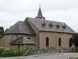
Kédange-sur-Canner (Lorraine Franconian: Kedéngen/Kiedéngen). is a commune in the Moselle department in Grand Est in north-eastern France.
See also
This article is issued from Wikipedia - version of the 11/17/2016. The text is available under the Creative Commons Attribution/Share Alike but additional terms may apply for the media files.