Juncalas
| Juncalas | ||
|---|---|---|
|
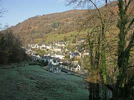
A general view | ||
| ||
 Juncalas | ||
|
Location within Occitanie region  Juncalas | ||
| Coordinates: 43°03′17″N 0°00′05″E / 43.0547°N 0.0014°ECoordinates: 43°03′17″N 0°00′05″E / 43.0547°N 0.0014°E | ||
| Country | France | |
| Region | Occitanie | |
| Department | Hautes-Pyrénées | |
| Arrondissement | Arrondissement of Argelès-Gazost | |
| Canton | Canton of Lourdes-Est | |
| Intercommunality | Communauté de communes de Castelloubon | |
| Government | ||
| • Mayor (2008–2014) | Léon Crampe | |
| Area1 | 3.51 km2 (1.36 sq mi) | |
| Population (1999)2 | 193 | |
| • Density | 55/km2 (140/sq mi) | |
| Time zone | CET (UTC+1) | |
| • Summer (DST) | CEST (UTC+2) | |
| INSEE/Postal code | 65237 / 65100 | |
| Elevation |
460–880 m (1,510–2,890 ft) (avg. 481 m or 1,578 ft) | |
|
1 French Land Register data, which excludes lakes, ponds, glaciers > 1 km² (0.386 sq mi or 247 acres) and river estuaries. 2 Population without double counting: residents of multiple communes (e.g., students and military personnel) only counted once. | ||
.svg.png)
Juncalas is a commune in the Hautes-Pyrénées department in south-western France.
See also
References
| Wikimedia Commons has media related to Juncalas. |
This article is issued from Wikipedia - version of the 3/15/2016. The text is available under the Creative Commons Attribution/Share Alike but additional terms may apply for the media files.