Juab County, Utah

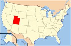
Juab County /ˈdʒuːæb/ is a county located in the U.S. state of Utah. As of the 2010 census, the population was 10,246.[1] Its county seat and largest city is Nephi.[2] The county was named from a Native American word meaning thirsty valley, or possibly only valley.
Juab County is part of the Provo–Orem, UT Metropolitan Statistical Area, which is also included in the Salt Lake City-Provo-Orem, UT Combined Statistical Area.
Geography

According to the U.S. Census Bureau, the county has a total area of 3,406 square miles (8,820 km2), of which 3,392 square miles (8,790 km2) is land and 14 square miles (36 km2) (0.4%) is water.[3]
Adjacent counties
- Tooele County (north)
- Utah County (northeast)
- Millard County (south)
- Sanpete County (east)
- White Pine County, Nevada (west)
National protected areas
- Fish Springs National Wildlife Refuge
- Fishlake National Forest (part)
- Uinta-Wasatch-Cache National Forest (part)
State protected areas
Demographics
| Historical population | |||
|---|---|---|---|
| Census | Pop. | %± | |
| 1860 | 672 | — | |
| 1870 | 2,034 | 202.7% | |
| 1880 | 3,474 | 70.8% | |
| 1890 | 5,582 | 60.7% | |
| 1900 | 10,082 | 80.6% | |
| 1910 | 10,702 | 6.1% | |
| 1920 | 9,871 | −7.8% | |
| 1930 | 8,605 | −12.8% | |
| 1940 | 7,392 | −14.1% | |
| 1950 | 5,981 | −19.1% | |
| 1960 | 4,597 | −23.1% | |
| 1970 | 4,574 | −0.5% | |
| 1980 | 5,530 | 20.9% | |
| 1990 | 5,817 | 5.2% | |
| 2000 | 8,238 | 41.6% | |
| 2010 | 10,246 | 24.4% | |
| Est. 2015 | 10,594 | [4] | 3.4% |
| U.S. Decennial Census[5] 1790–1960[6] 1900–1990[7] 1990–2000[8] 2010–2014[1] | |||
As of July 1, 2015,[9] the US Census Bureau estimates that there were 10,594 people, 3,557 housing units, and 3,557 housing units in the county. The population density was 3 people per square mile (1/km²).[10] There were 3,066 households. The racial makeup of the county was 96.4% White, 0.4% Black or African American, 1.0% Native American, 0.4% Asian, 0.2% Pacific Islander, and 1.5% from two or more races. 4.7% of the population were Hispanic or Latino of any race.
In 2010,[11] there were 3,093 households out of which 47.8% had children under the age of 18 living with them, 68.50% were married couples living together, 8.80% had a female householder with no husband present, and 19.40% were non-families. 17.30% of all households the householder lived alone. The average household size was 3.27 and the average family size was 3.74.
In the county, the population was spread out with 40.1% 19 and younger, 5.0% from 20 to 24, 24.80% from 25 to 44, 20.1% from 45 to 64, and 10.2% who were 65 years of age or older. The median age was 29.3 years. 51% of the population was male and 49% was female.
The median income for a household in the county was $56,976. The per capita income for the county was $18,503 and 11.4% of the population were below the poverty line.
Communities

Currently populated communities in Juab County:
- Callao
- Eureka
- Levan
- Mills
- Mona
- Nephi (county seat)
- Partoun
- Rocky Ridge
- Santaquin (part)
- Trout Creek
See also
References
- 1 2 "State & County QuickFacts". United States Census Bureau. Retrieved December 29, 2013.
- ↑ "Find a County". National Association of Counties. Retrieved 2011-06-07.
- ↑ "2010 Census Gazetteer Files". United States Census Bureau. August 22, 2012. Retrieved June 25, 2015.
- ↑ "County Totals Dataset: Population, Population Change and Estimated Components of Population Change: April 1, 2010 to July 1, 2015". Retrieved July 2, 2016.
- ↑ "U.S. Decennial Census". census.gov. United States Census Bureau. Retrieved 25 Jun 2015.
- ↑ "Historical Census Browser". lib.virginia.edu. University of Virginia Library. Retrieved 25 Jun 2015.
- ↑ Forstall, Richard L., ed. (25 Jun 1995). "Population of Counties by Decennial Census: 1900 to 1990". census.gov. United States Census Bureau. Retrieved 27 Mar 2015.
- ↑ "Census 2000 PHC-T-4. Ranking Tables for Counties: 1990 and 2000" (PDF). census.gov. United States Census Bureau. 2 Apr 2001. Retrieved 25 Jun 2015.
- ↑ "Bachelor's degree or higher, percent of persons age 25 years+, 2010-2014". www.census.gov. Retrieved 2016-04-21.
- ↑ "Juab County UT Demographics data". www.towncharts.com. Retrieved 2016-04-21.
- ↑ Bureau, U.S. Census. "American FactFinder - Results". factfinder.census.gov. Retrieved 2016-04-22.
External links
| Wikimedia Commons has media related to Juab County, Utah. |
- Official website
- Juab County Fair (official website)
- Juab County Sheriff's Office (official website)
- Juab Travel Council (official website)
- Ghost Towns of Juab County (on ghosttowns.com)
 |
Tooele County | Utah County | | |
| |
|
Sanpete County | ||
| ||||
| | ||||
| Millard County |
Municipalities and communities of Juab County, Utah, United States | ||
|---|---|---|
| Cities | 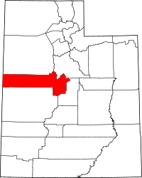 | |
| Towns | ||
| Unincorporated communities | ||
| Ghost towns | ||
| Footnotes | ‡This populated place also has portions in an adjacent county or counties | |
Coordinates: 39°43′N 112°48′W / 39.71°N 112.80°W