Joliet Regional Airport
| Joliet Regional Airport | |||||||||||||||
|---|---|---|---|---|---|---|---|---|---|---|---|---|---|---|---|
 | |||||||||||||||
| IATA: JOT – ICAO: KJOT – FAA LID: JOT | |||||||||||||||
| Summary | |||||||||||||||
| Airport type | Public | ||||||||||||||
| Owner/Operator | Joliet Park District | ||||||||||||||
| Serves | Joliet, Illinois | ||||||||||||||
| Elevation AMSL | 582 ft / 177 m | ||||||||||||||
| Coordinates | 41°31′04″N 088°10′32″W / 41.51778°N 88.17556°W | ||||||||||||||
| Website | Official site | ||||||||||||||
| Runways | |||||||||||||||
| |||||||||||||||
| Statistics (2010) | |||||||||||||||
| |||||||||||||||
|
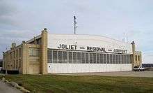
Joliet Park District Airport Hangar Building | |
  | |
| Location | Joliet, Illinois |
|---|---|
| Coordinates | 41°31′04″N 88°10′32″W / 41.51778°N 88.17556°WCoordinates: 41°31′04″N 88°10′32″W / 41.51778°N 88.17556°W |
| Built | 1930 |
| Architectural style | Art Deco with Streamline Moderne |
| NRHP Reference # | 80001419[3] |
| Added to NRHP | 1980 |
Joliet Regional Airport (IATA: JOT, ICAO: KJOT, FAA LID: JOT) is a public use airport located four nautical miles (7 km) west of the central business district of Joliet, a city in Will County, Illinois, United States. It is owned by the Joliet Park District.[2]
The airport is also 37 miles (60 kilometers) southwest of Chicago. It opened in April 1930.
History
Joliet's first airport, Originally known as Joliet Municipal Airport, was proposed by Illinois Senator Richard Barr in the mid-1920s. It was operated by the Joliet Park District, the first airport in the country to be operated by such an authority. The land was purchased in September 1928 and the airport was built with assistance from the United States Department of Commerce. The airport was dedicated in September 1930, with an aerobatics show and bomb-dropping. The Park District relocated their main office to the airport. Most operations were transferred to a new airfield in 1940. A transmitter is still functional at the old airport and the hangar was added to the National Register of Historic Places in 1980.
Facilities and aircraft
Joliet Regional Airport covers an area of 178 acres (72 ha) at an elevation of 581 feet (177 m) above mean sea level. It has two runways: 12/30 is 2,937 by 100 feet (895 x 30 m) with an asphalt pavement and 4/22 is 2,746 by 150 feet (837 x 45m) with a turf surface.[2]
For the 12-month period ending December 31, 2006, the airport had 25,000 aircraft operations, an average of 68 per day: 89% general aviation, 8% air taxi, and 3% military. At that time there were 114 aircraft based at this airport: 91% single-engine, 6% multi-engine and 3% helicopter.[2]
See also
References
- ↑ Joliet Regional Airport, official web site
- 1 2 3 4 FAA Airport Master Record for JOT (Form 5010 PDF), effective 2009-1-15
- ↑ "National Register of Historic Places". National Park Service. 2010-07-14.
External links
- FAA Terminal Procedures for JOT, effective November 10, 2016
- Resources for this airport:
- FAA airport information for JOT
- AirNav airport information for KJOT
- ASN accident history for JOT
- FlightAware airport information and live flight tracker
- NOAA/NWS latest weather observations
- SkyVector aeronautical chart, Terminal Procedures