Grafenwöhr
| Grafenwöhr | ||
|---|---|---|
| ||
 Grafenwöhr | ||
Location of Grafenwöhr within Neustadt a.d.Waldnaab district 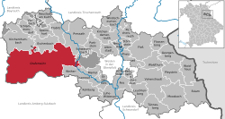 | ||
| Coordinates: 49°43′N 11°54′E / 49.717°N 11.900°ECoordinates: 49°43′N 11°54′E / 49.717°N 11.900°E | ||
| Country | Germany | |
| State | Bavaria | |
| Admin. region | Upper Palatinate | |
| District | Neustadt a.d.Waldnaab | |
| Government | ||
| • Mayor | Edgar Knobloch | |
| Area | ||
| • Total | 216.24 km2 (83.49 sq mi) | |
| Population (2015-12-31)[1] | ||
| • Total | 6,521 | |
| • Density | 30/km2 (78/sq mi) | |
| Time zone | CET/CEST (UTC+1/+2) | |
| Postal codes | 92655 | |
| Dialling codes | 09641 | |
| Vehicle registration | NEW | |
| Website | www.grafenwoehr.de | |

Grafenwöhr (Northern Bavarian: Groafawehr) is a town in the district Neustadt (Waldnaab), in the region of the Upper Palatinate (German: Oberpfalz) in eastern Bavaria, Germany. It is widely known for the United States Army military installation and training area, called Grafenwöhr Training Area (Tower Barracks), located directly south and west of the town.
History
Early History
The town of Grafenwöhr (Island of the Count), was founded in the 9th century on an island (wöhr), located between the river Creussen and the Thum stream. In its early history, the inhabitants and the town of Grafenwöhr proper belonged to nobles from Schweinfurt, Bamberg, and Leuchtenberg.
20th century
In 1907, Prince Luitpold, regent of the Kingdom of Bavaria, selected the area near the town of Grafenwöhr as the place best suited for training of the Bavarian Army (1806–1919). Construction began in 1908, and, by 1915, the training reservation was 96 square kilometres (37 sq mi) in area; the first artillery round was fired in the training area at 08:00 on 30 June 1910. Throughout World War I (1914–1918) the Grafenwöhr training area was used for equipping and training army units for combat. After the War, the High Command, Berlin, used Grafenwöhr to train the 100,000–man German army, allowed by the Treaty of Versailles (1919). In 1936, the Nazi Government expanded the training area to the present size of 230 square kilometres (90 sq mi). On 5 and 8 April 1945, the training camp and the town of Grafenwöhr proper were bombed during Allied air raids. The last German Army Commander of the Grafenwöhr training area surrendered to the U.S. Army on 20 April 1945. Afterwards, during the Cold War (1945–1991), the Grafenwöhr training area was an important, combined arms training site for the U.S. Army and allied forces.
Post Cold War
The military installation is also home to one of the largest Army construction projects in Europe, called Efficient Basing-Grafenwöhr. The Grafenwöhr Training Area (Tower Barracks) houses the 7th Army Joint Multinational Training Command (JMTC). The 7th Army JMTC owns almost all of the U.S. Army training facilities and assets in Europe. The Grafenwöhr Training Area is one of its largest training areas and includes ranges that can accommodate nearly every weapons system currently used. Though operated by the U.S. Army, the area is the largest multinational training area in Europe. Grafenwöhr (Tower Barracks), also known as the East Camp, is the main post and is located on the north east edge of the training area. The Vilseck military community, also known as Rose Barracks, or the South Camp, is on the southern boundary.
The Grafenwöhr Army Airfield provides air flow to all air traffic requesting services including but not limited C-130's from the 37th Airlift Squadron at Ramstein AB, Germany. The airfield is manned 24 hours a day by advisory services and at a minimum from 08:00 to 17:00 by air traffic controllers both in a control tower and an approach control. Due to its length and relative proximity to the JMTC training area, it makes for a realistic simulation of short field operations encountered around the world. Bunker dropzone is also located within the Grafenwöhr Training Area. It is used to practice airdrop of troops, equipment, and supplies.
Tenant Units
- 7th U.S. Army Joint Multinational Training Command
- 7th Warrior Training Brigade
- 18th Combat Sustainment Support Battalion
-
 7th Weather Squadron
 - 535th Engineer Company
-
 902d Engineer Company
 - 12th Chemical Company
- 44th Expeditionary Signal Battalion
- 102nd Signal Battalion
-
 709th Military Police Battalion
 - 615th Military Police Company
- 512th Military Police Platoon (Augmentation)
- 514th Military Police Platoon (Augmentation)
- 57th Signal Company
- 504th Military Intelligence Company
- A/106th Financial Management Support Unit
- C CO USA NATO, AFNORTH BN
- 1-91 CAV, 173rd IBCT (A)
Former Units
-
 172d Infantry Brigade Combat Team (inactivated on 31 May 2013)
-
 2d Battalion, 28th Infantry Regiment (inactivated 31 May 2013)
 -
 3d Battalion, 66th Armor Regiment (inactivated 31 May 2013).
 -
 Troop E, 5th Cavalry Regiment (inactivated 31 May 2013)
 -
 1st Battalion, 2d Infantry Regiment (inactivated 31 May 2013)
-
- Battery B (Target Acquisition), 25th Field Artillery
- 15th Medical Detachment (Air Ambulance) (1970 - 1989)
- 498th Support Battalion, 2d Armored Division (1975-1979)
- Detachment 6 (Forward Air Control Post), 601st Tactical Control Squadron, USAFE (1965-1969)
- Became Detachment 26 (Forward Air Control Post), 601st Tactical Control Squadron, USAFE (1969-1973)
- Became the 632nd Tactical Control Flight, 601st Tactical Control Wing, USAFE (in 1973, inactivated 1 August 1986)
Geography
The civilian town of Grafenwöhr rests nestled between low hills. The area is widely forested and the nearby region is mostly used for agricultural purposes. Farms and dairies cover much of the surrounding landscape. Grafenwöhr is positioned geographically such that it experiences very mild summers and cold winters.
Climate
Climate in this area has mild differences between highs and lows, and there is adequate rainfall year round. The Köppen Climate Classification subtype for this climate is "Cfb" (Marine West Coast Climate/Oceanic climate).[2]
| Climate data for Grafenwöhr | |||||||||||||
|---|---|---|---|---|---|---|---|---|---|---|---|---|---|
| Month | Jan | Feb | Mar | Apr | May | Jun | Jul | Aug | Sep | Oct | Nov | Dec | Year |
| Average high °C (°F) | 1 (33) |
3 (37) |
7 (45) |
12 (54) |
18 (64) |
21 (69) |
23 (73) |
22 (72) |
18 (65) |
13 (55) |
6 (42) |
2 (35) |
12 (54) |
| Average low °C (°F) | −6 (22) |
−5 (23) |
−2 (28) |
1 (34) |
6 (42) |
8 (47) |
10 (50) |
10 (50) |
7 (44) |
3 (37) |
−1 (31) |
−4 (25) |
2 (36) |
| Average precipitation mm (inches) | 48 (1.9) |
38 (1.5) |
43 (1.7) |
41 (1.6) |
56 (2.2) |
74 (2.9) |
69 (2.7) |
61 (2.4) |
50 (2) |
46 (1.8) |
50 (2) |
56 (2.2) |
632 (24.9) |
| Average precipitation days | 15 | 12 | 13 | 12 | 14 | 15 | 12 | 12 | 12 | 11 | 15 | 15 | 158 |
| Source: Weatherbase [3] | |||||||||||||
Sports
- Soccer. SV Grafenwöhr. The adults and children mostly all are in either the Kreisliga or Bezirksoberliga.[4]
- Fishing. The area around Grafenwöhr is excellent for fishing. There are many lakes on the training area and the surrounding area that are fished. Common fish landed in the area are Carp, Pike, Rainbow Trout, and Brown Trout.
- Hunting. The area around Grafenwöhr is heavily forested and provides for excellent hunting. Wild boar (Wildschwein), roe deer (Reh) and red deer (Rotwild) are the most commonly hunted animals.
- Other. The U.S. Military hosts a wide variety of sports within the boundaries of the camps.
Transport
- Road. Grafenwöhr is located along Bundesstrasse B299. Civilian transportation to, from, in, and around Grafenwöhr is limited to the automobile. There are a limited number of taxi and bus services available.
- Rail. The only railroad in Grafenwöhr is strictly for military use and transport only. However, there are several rail stations nearby where civilian passenger trains run. The closest Bahnhofs (rail stations) are Pressath, Schwarzenbach, Freihung, and Vilseck.
- Air. The only airfield in Grafenwöhr is strictly for military use and transport only. The closest international airport is located in Nuremberg, approximately 90 kilometers away.
VIPs and Important Visitors
- Prince Luitpold, (1821-1912), gave the approval to build the training area on December 9, 1906. [5]
- Elvis Presley, (1935-1977), was on the military training place from November 3, 1958 , for six weeks while he was doing his military service. [6]
Media
American Forces Network (AFN) Bavaria broadcasts from the Grafenwöhr Training Area. Bavarian Times Magazine provides news, shopping, dining and other information about the Grafenwohr area. The Bavarian Times is a military magazine for the Grafenwöhr Training Area
Photo gallery
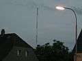 Grafenwöhr AFN FM radio mast
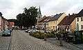 Grafenwöhr city center
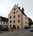 The Grafenwöhr Rathaus (Town Hall)
_001.jpg) Church Pfarrkirche Mariä Himmelfahrt
Church Pfarrkirche Mariä Himmelfahrt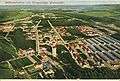 Training camp and area around 1911
References
- ↑ "Fortschreibung des Bevölkerungsstandes". Bayerisches Landesamt für Statistik und Datenverarbeitung (in German). June 2016.
- ↑ Climate Summary for Grafenwöhr
- ↑ "Weatherbase.com". Weatherbase. 2013. Retrieved on June 15, 2013.
- ↑ SV-Grafenwöhr Online
- ↑ http://www.weber-rudolf.de/errichtung.htm
- ↑ Olaf Meiler (2005-01-11). "Elvis Presley als Soldat auf dem Truppenübungsplatz Grafenwöhr i.d. Oberpfalz" (text/html) (in German). Deutsch-Amerikanisches Volksfest Grafenwöhr. Retrieved 2014-05-12.
External links
| Wikimedia Commons has media related to Grafenwöhr. |
- Bob Decker's site includes a couple of stylized maps showing Graf
- 7th Army JMTC website
- "Elvis in der Oberpfalz" (german)