Johns Island, South Carolina


Johns Island, also spelled John's Island, is an island in Charleston County, South Carolina, United States, and is the largest island in the state of South Carolina. Johns Island is bordered by the Wadmalaw, Seabrook, Kiawah, Edisto, Folly, and James islands; the Stono and Kiawah rivers separate Johns Island from its border islands. It is the fourth largest island on the US east coast, surpassed only by Long Island, Mount Desert Island, and Martha's Vineyard. Johns Island is 84 square miles (220 km2) in area, with a population of 14,000 people.
Johns Island was named after Saint John Parish in Barbados by the first settlers to the island.[1]
Wildlife
The island is home to scores of wildlife species, including deer, alligators, raccoons, coyotes, bobcats, otters and wild hogs. The rivers and marshes abound with fish and shellfish, especially oysters, and dolphins. The number of bird species is in the hundreds. They include bald eagles, osprey, wild turkeys, owls, hawks, herons, egrets and ducks. The flora is also abundant with many native and imported species as well as agricultural crops.
History
Colonial era (1670–1776)
Johns Island was originally inhabited by nomadic tribes of Native Americans such as the Kiawah, who survived by hunting.[2] By the time Europeans arrived in the area, these tribes were already settled and farming off the land.[2] The Native America tribes in this area included the Stono and the Bohicket. Initially, the Stono and European settlers had good relations. However, after the Stono killed some of the European’s livestock, the whites murdered several Indians in retaliation.[2] Johns Island had scattered settlements that were situated near the water by the 1670s. Maps dated from 1695 and 1711 show plantations established on the banks of the Stono River.[2] During the colonial period, the main crop that was produced was indigo, prized for its rich blue dye. The plantations that grew crops, including indigo, relied on slave labor.
The Stono Rebellion, which occurred on Johns Island in 1739, began as an attempt by a group of slaves to escape to Spanish Florida, where they were promised freedom.[2] Beginning in the early morning hours of September 9, 1739, a group of about twenty slaves met near the Stono River, led by a slave named Jemmy. The group then proceeded to the Stono Bridge and raided Hutchinson's Store. They took food, ammunition, and supplies. The group of slaves then killed the two shopkeepers, leaving their heads on the front steps of the store.[2] The slaves then crossed the Stono River and gathered more followers as they began to walk to Spanish Florida. The runaways met with Lieutenant Governor William Bull and four of his comrades also traveling on the road. Seeing the situation at hand, Lieutenant Governor Bull and his companies rallied other plantation owners to help put down the opposition. The plantation owners attacked and put down the resistance and executed all who could not prove that they were forced to join the march.[2]
American Revolution (1776–1785)
The American Revolutionary War arrived on Johns Island in May 1779 as a body of British troops under the command of General Augustine Prevost.[2] General Prevost established a small force to remain on the island, headed by Lieutenant Colonel John Maitland. Under the command of Sir Henry Clinton, more troops landed on Seabrook Island, beginning February 11, 1780.[2] Clinton’s goal was to cross Johns Island and James Island and lay siege to Charleston. Clinton’s army crossed the Stono River and set up temporary headquarters at Fenwick Hall. Moving to James Island, marching up the west bank of the Ashley River to Old Town Landing then marching south to Charleston, Clinton besieged the city. Charleston surrendered to British forces on May 12, 1780; the occupation lasted until December 1782.
Civil War (1861–1865)
The Battle of Bloody Bridge, also known as Burden's Causeway, occurred on Johns Island in July 1864. The site of the battle is off River Road, just north of the Charleston Executive Airport. On July 2, 1864, Brigadier General John Hatch's troops landed in the Legareville section of Johns Island.[3] Hatch wanted to cross Johns Island, then cross the Stono River and lay siege to James Island. The Union troops met the Confederate troops where the creek turns into swamp. Around 2,000 South Carolina soldiers held off a Union force of roughly 8,000 men.[3] After three days of fighting, Hatch's troops left the island.
Background
Johns Island is located to the west of James Island and to the east of Wadmalaw Island and inshore of Seabrook Island and Kiawah Island. It is separated from the mainland by the tidal Stono River, which forms part of the Intracoastal Waterway. Roughly one-third of the island is within the city limits of Charleston. The island is home to the Angel Oak, a Southern live oak tree estimated to be 400–1500 years old and named for Justus Angel, nineteenth century owner of the land on which it stands.[4][5][6] It is also known for its farms, producing tomatoes and numerous other agricultural products.
The population of Johns Island is growing. Between 2000 and 2010 the islands population grew by 50%, the largest increase in the history of the island. This trend is expected to continue but numerous conservation organizations are striving for ecologically friendly growth.
The island's proximity to downtown Charleston and its scenic property have made it an active location for development. Numerous high density developments have been created in parts of the island zoned into the City of Charleston. Most of the island still rests within the jurisdiction of Charleston County.
Several movies have been filmed on the island, including The Notebook (2004).
Attractions
Johns Island Presbyterian Church
Johns Island Presbyterian Church on Bohicket Road was first built in 1719.[7] The church began as part of Reverend Archibald Stobo's plan to create five Presbyterian churches in the rural areas of South Carolina.[8] Notably, it is one of the oldest churches in the United States built from a wood frame. Johns Island Presbyterian underwent expansions in 1792 and 1823. The church is open to the public and offers tours and part of the National Register of Historic Places. As of 2012, the church was under the direction of Reverend Jon Van Deventer.[9]
Angel Oak
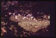
The Angel Oak is a live Southern live oak tree located on Johns Island.[5] Estimates of the tree's age range from 400 to 1500 years old.[5][6] The oak is 65 ft (20 m) tall, with a trunk circumference of 25.5 ft (7.8 m).[10] In spite of the popular belief that the Angel Oak is the oldest tree east of the Mississippi River, there are many baldcypress trees throughout the south which are many hundreds of years older.[11] The Angel Oak stands on part of the land given to Jacob Waight in 1717 as part of a land grant. The Angel Oak was acquired by the City of Charleston in 1991.[12] Today, Angel Oak Park provides visitors a close look at the tree. The park area is complete with a gift shop and picnic tables.
Mullet Hall Equestrian Center
Mullet Hall Equestrian Center is located on Mullet Hall Road on Johns Island.[13] With 738 acres and 20 miles of trails, it is home to equestrian competitions, festivals, and events. Planning for the Mullet Hall Equestrian Center began in 2000[14] The center includes four show rings, 1 Grand Prix ring, 40 acres of grass fields, 196 horse stalls and both jumping and lunging areas.
Battle of Charleston reenactment
An annual Battle of Charleston reenactment is held at Legare Farms, located off of River Road, on Johns Island. The event includes battle reenactments, food, music, and culture of the 19th century, began in 2004.[15] One of the battles reenacted during the event includes the Johns Island 1864 "Battle of Bloody Bridge". As of 2013 this event is now a "timeline" reenactment of all AmericanWars.
In addition to the John's Island Presbyterian Church, the Moving Star Hall and The Progressive Club are listed on the National Register of Historic Places.[16]
Education
- Angel Oak Elementary School[17]
- Capers Preparatory Christian Academy
- Charleston Collegiate School is a college preparatory school on the island; it serves students in the Charleston area in grades K4-12.[18]
- Haut Gap Middle School[19]
- Montessori School of Johns Island is a Montessori school on the island, serving the children of Charleston area. It is located off of Main Road, near West Ashley. Children from 12 weeks to 12 years are prepared for a lifetime of learning through a Montessori method of education.[20]
- Mount Zion Elementary School
- St. John's High School[21]
Museums and Library
Johns Island Branch Library
The Johns Island Branch Library, located off of Maybank Highway, is part of the Charleston County Public Library system. The $4.3 million library, which opened on October 24, 2004, is the largest of the Charleston County Public Library branches.[22] At 16,000 square feet, the library is more than twice the size of the county's normal library branches.[22] The library was built to serve Johns Island, Wadmalaw Island, Kiawah Island and Seabrook Island. Planning of the library took five years, with the groundbreaking of the project occurring in December 2003.
Bridges
References
- General references
- U.S. Geological Survey Geographic Names Information System: Johns Island (island)
- U.S. Geological Survey Geographic Names Information System: Johns Island (populated place)
- Specific citations
- ↑ Haynie, Connie Walpole (2007). Johns Island. Charleston: Arcadia Publishing. p. 4. ISBN 9780738543468.
- 1 2 3 4 5 6 7 8 9 Preservation Consultants Inc. (1989). James Island and Johns Island Historical and Architectural Inventory (PDF). pp. 4, 5, 6, 11, 14, 23, 25, 29.
- 1 2 Peterson, Bo (10 July 2010). "Obscure Civil War battle fought on Johns Island". Post and Courier. Retrieved 24 October 2012.
- ↑ Angel Oak photos
- 1 2 3 Angel Oak Tree at AngelOakTree.com
- 1 2 Angel Oak Tree at AngelOakTree.org
- ↑ Haynie, Connie Walpole (2007). John's Island. Charleston, SC: Arcadia Pub. p. 11. ISBN 978-0738543468.
- ↑ Kornwolf, James D. (2002). Architecture and Town Planning in Colonial North America, Volume 2. Baltimore: The Johns Hopkins University Press. p. 901. ISBN 9780801859861.
- ↑ Parker, Adam (23 March 2012). "Johns Island Presbyterian: Unmovable". Post and Courier. Retrieved 18 October 2012.
- ↑ Zepke, Terrance (2006). Coastal South Carolina: Welcome to the Lowcountry. Sarasota: Pineapple Press. p. 143. ISBN 9781561643486.
- ↑ "Visiting Ancient Baldcypress on the Black River". The Nature Conservancy. Retrieved 23 September 2013.
- ↑ "The Angel Oak Tree". The City of Charleston. Retrieved 23 October 2012.
- ↑ Porter, Arlie (29 March 2000). "Limehouse: John's Is. Horse Center Too Remote". Post and Courier. Retrieved 18 October 2012.
- ↑ Shumake, Janice (8 June 2000). "Plans Offered for Equestrian Park". Post and Courier. Retrieved 18 October 2012.
- ↑ "Battle of Charleston re-enactment at Legare Farms". Post and Courier. 18 March 2012. Retrieved 18 October 2012.
- ↑ National Park Service (2010-07-09). "National Register Information System". National Register of Historic Places. National Park Service.
- ↑ "CCSD Angel Oak Elementary School". Charleston County School District. Retrieved 23 October 2012.
- ↑ "Charleston Collegiate". Charleston Collegiate. Retrieved 23 October 2012.
- ↑ "CCSD Haut Gap Middle School". Charleston County School District. Retrieved 23 October 2012.
- ↑ "Montessori School of Johns Island". Montessori School of Johns Island. Retrieved 21 October 2014.
- ↑ "CCSD St. Johns High School". Charleston County School District. Retrieved 23 October 2012.
- 1 2 Fennell, Edward (26 October 2004). "$4.3M Johns Island Branch Library opens today". Post and Courier. Retrieved 18 October 2012.
External links
| Wikimedia Commons has media related to John's Island. |
Coordinates: 32°42′09″N 80°02′53″W / 32.70250°N 80.04806°W
Municipalities and communities of Charleston County, South Carolina, United States | ||
|---|---|---|
| Cities | 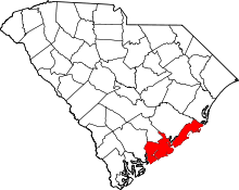 | |
| Towns | ||
| CDP | ||
| Unincorporated communities | ||
| Footnotes | ‡This populated place also has portions in an adjacent county or counties | |