John o' Groats Trail
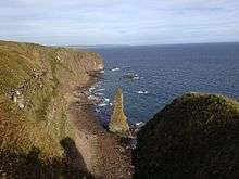
The John o’Groats Trail is a Scottish long-distance walking route from Inverness to John o’Groats, traversing back lanes, footpaths, shorelines and cliff tops of the Scottish Highlands. The trail gives access to accommodation, meals and shops at the end of most stages of the walk.
The trail is currently being developed. Work began in March 2015. All of the route is walkable, and many sections of the coastal route are walked frequently by local walkers as well as long-distance walkers. However, work is ongoing to bring the trail up to the usual standards for walking trails. Basic infrastructure such as markers, stiles, and bridges are still needed in many places. Most work is being carried out on a voluntary basis.
The walk presents some obstacles that an established trail normally would not. Some stages currently require barbed wire crossing, stone wall climbing, river fording, boulder scrambling, and strenuous walking through summer vegetation. All of these can be dangerous activities if not done with care by a fit, experienced walker.
The Route
The John o’Groats Trail is 144.6 miles (231.4 km) long. It is divided into 14 stages that are each easily walkable in a day. Most stages end in a town or village that provides accommodation.
The following cities/towns are the stage endpoints for the trail:
- Inverness
- Culbokie
- Alness
- Tain
- Dornoch
- Golspie
- Brora
- Helmsdale
- Berriedale
- Dunbeath
- Lybster
- Whaligoe
- Wick
- Keiss
- John o' Groats