Jhelum Valley (Kashmir)
| Jhelum Valley وادی جہلم | |
|---|---|
| Valley | |
 | |
 Jhelum Valley | |
| Coordinates: 34°10′09″N 73°44′36″E / 34.1691°N 73.7432°ECoordinates: 34°10′09″N 73°44′36″E / 34.1691°N 73.7432°E | |
| Country |
|
| State | Azad Kashmir |
| District | Hattian Bala |
| Languages | |
| • Official | Urdu |
| Time zone | PST |
| Website | http://jvc.ajku.edu.pk/Jhelum.php |
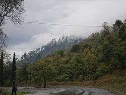
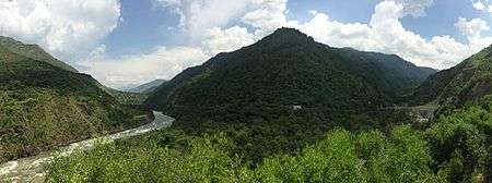
Jhelum Valley (Urdu: وادی جہلم ) is a valley in Hattian Bala District of Azad Kashmir, Pakistan. It is a 50 kilometers (31 mi) long valley located along with Jhelum river surrounded by lush green mountains.[1] Hattian Bala is the main town and district headquartered in the valley.
Some popular tourist attractions are Garhi Dupatta, Awan Patti, Chinari, Chakothi and Chikkar. The valley is connected by a metallic road from Muzaffarabad.[2]
Hotels and rest houses with basic facilities are located in towns and villages in valley. Health facilities, education institutes, post offices, and land line phone service are also available.
University of Azad Jammu kashmir Jhelum Valley Campus
Jhelum Valley Campus in the heavenly scenic Jhelum valley so as to be give people of this area an access to higher education at their door steps. The main setup of the Jhelum Campus will be at Hattian Bala beautiful junction of important areas of Bagh, Chanari, Leepa, Chokothi, Gari Dopatha and Muzaffarabad. Jhelum Campus is along the Site of Sirinagar Highway which remained a trade route between Indian held and liberation part of Azad Jammu & Kashmir.

References
- ↑ "Jhelum Valley". Azad Jammu & Kashmir Council. Retrieved 7 July 2013.
- ↑ "Jhelum valley". jhelumvalley.com. Retrieved 7 July 2013.