Jhansi
| Jhansi | |
|---|---|
|
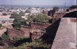
View From Jhansi Fort towards the city | |
|
Nickname(s):
| |
 Jhansi | |
| Coordinates: 25°26′55″N 78°34′11″E / 25.44862°N 78.56962°ECoordinates: 25°26′55″N 78°34′11″E / 25.44862°N 78.56962°E | |
| Country | India |
| State | Uttar Pradesh |
| Region | Bundelkhand |
| District | Jhansi |
| Founded by | Raja of Orchha |
| Government | |
| • Mayor | Kiran Verma[1] |
| • Assistant Superintendent | Dinesh Kumar Singh[2] |
| Elevation | 285 m (935 ft) |
| Population (2011 census) | |
| • City | 505,693[3] |
| • Rank | 57 |
| • Metro | 547,638[3] |
| Languages | |
| • Official | Hindi |
| • Other | Bundeli |
| Time zone | IST (UTC+5:30) |
| PIN | 284001-2-3-4 |
| Telephone code | 0510 |
| Vehicle registration | UP-93 |
| Sex ratio | ♂ 0.905 : ♀ 1.000 |
| Literacy | 83.02%[3] |
| Avg. summer temperature | 47 °C (117 °F) |
| Avg. winter temperature | 4.0 °C (39.2 °F) |
Jhansi (![]() pronunciation ) is a historic city in the Indian state of Uttar Pradesh. It lies in the region of Bundelkhand on the banks of the Pahuj River, in the extreme south of Uttar Pradesh. Jhansi is the administrative headquarters of Jhansi district and Jhansi division. Called the Gateway to Bundelkhand, Jhansi is situated between the rivers Pahuj and Betwa at an average elevation of 285 metres (935 feet). It is about 415 kilometres (258 mi) from New Delhi and 292 kilometres (181 mi) from Lucknow.
pronunciation ) is a historic city in the Indian state of Uttar Pradesh. It lies in the region of Bundelkhand on the banks of the Pahuj River, in the extreme south of Uttar Pradesh. Jhansi is the administrative headquarters of Jhansi district and Jhansi division. Called the Gateway to Bundelkhand, Jhansi is situated between the rivers Pahuj and Betwa at an average elevation of 285 metres (935 feet). It is about 415 kilometres (258 mi) from New Delhi and 292 kilometres (181 mi) from Lucknow.
The original walled city grew around its stone fort which crowns a neighbouring rock. The ancient name of the city was Balwantnagar. From 1817 to 1854, Jhansi was the capital of the princely state of Jhansi which was ruled by Maratha rajas. The state was annexed by the British Governor General in 1854; Damodar Rao's claim to the throne was rejected but Rani Lakshmibai ruled it from June 1857 to June 1858.
Jhansi is well connected to all other major towns in Uttar Pradesh by road and railway networks. The National Highways Development Project has supported development of Jhansi.Srinagar to Kanyakumari North-South corridor passes through Jhansi as does the East-West corridor; consequently there has been a sudden rush of infrastructure and real estate development in the city. A greenfield airport development has been planned.[4] On 28 August, 2015 Jhansi was selected among 98 cities for smart city initiative by Government of India.[5][6][7]
Etymology

According to a legend the Raja of Orchha was sitting on the roof of his palace with his friend, the Raja of Jaitpur, and asked the latter whether he could discern this new fort that he had built on Bangara hill, and he replied that he could see it 'jhainsi' (meaning rather indistinct). This name 'Jhainsi' in course of time became corrupted to 'Jhansi'. It was one of the most strategically situated forts of central India being built on an elevated rock rising out of the plain and commanding the city and the surrounding country.
History
In the 18th century the town of Jhansi served as the capital of a Maratha province and later the Princely State of Jhansi from 1804 till 1853, when the territory became a part of British India.
Demographics
According to the 2011 census, Jhansi has a population of 505,693, its urban agglomeration a population of 547,638. The literacy rate of Jhansi is 83.02%, higher than the state average of 67.68%. The sex ratio is 905 females for every 1000 males.[8] Jhansi city has 57th rank among the most populated cities of India, according to the 2011 census.
Jhansi Cantonment
According to the Indian Census of 2001[9] there were 21,917 people in Jhansi Cantonment, of whom 56% were male and 44% female (men 12,264; women 9,653; children 2,612). The rate of literacy was 80%.
Geography and climate
Jhansi is located at 25.4333 N 78.5833 E. It has an average elevation of 284 metres (935 feet).[10] Jhansi lies on the plateau of central India, an area dominated by rocky relief and minerals underneath the soil. The city has a natural slope in the north as it is on the south western border of the vast Tarai plains of Uttar Pradesh and the elevation rises on the south.

The land is suitable for species of citrus fruit and crops include wheat, pulses, peas, and oilseeds. The region relies heavily on Monsoon the rains for irrigation purposes. Under an ambitious canal project (the Rajghat canal), the government is constructing a network of canals for irrigation in Jhansi and Lalitpur and some part of Madhya Pradesh. The trade in agricultural products (including grain and oilseeds) is of great economic importance.[11] The city is also a centre of brassware manufacture.[12]
Climate
Being on a rocky plateau, Jhansi experiences extreme temperatures. Winter begins in October with the retreat of the Southwest Monsoon (Jhansi does not experience any rainfall from the Northeast Monsoon) and peaks in mid-December. The mercury generally reads about 4 degrees minimum and 21 degrees maximum. Spring arrives by the end of February and is a short-lived phase of transition. Summer begins by April and summer temperatures can peak at 47 degrees in May. The rainy season starts by the third week of June (although this is variable year to year). Monsoon rains gradually weaken in September and the season ends by the last week of September. In the rainy season, the average daily high temperature hovers around 36 degrees Celsius with high humidity. The average rainfall for the city is about 900 mm per year, occurring almost entirely within the three-and-a-half months of the Southwest Monsoon. In summer Jhansi experiences temperatures as high as 45-47 degrees and in winter the temperatures fall as low as 0-1 degrees (recorded in winter 2011).
| Climate data for Jhansi (1971–2000) | |||||||||||||
|---|---|---|---|---|---|---|---|---|---|---|---|---|---|
| Month | Jan | Feb | Mar | Apr | May | Jun | Jul | Aug | Sep | Oct | Nov | Dec | Year |
| Record high °C (°F) | 33.8 (92.8) |
39.4 (102.9) |
43.3 (109.9) |
46.2 (115.2) |
48.0 (118.4) |
47.8 (118) |
45.6 (114.1) |
42.2 (108) |
40.6 (105.1) |
40.6 (105.1) |
38.1 (100.6) |
33.1 (91.6) |
48.0 (118.4) |
| Average high °C (°F) | 23.3 (73.9) |
26.9 (80.4) |
33.3 (91.9) |
39.3 (102.7) |
42.3 (108.1) |
40.5 (104.9) |
34.0 (93.2) |
32.2 (90) |
33.3 (91.9) |
33.9 (93) |
29.6 (85.3) |
24.5 (76.1) |
32.9 (91.2) |
| Average low °C (°F) | 7.4 (45.3) |
10.3 (50.5) |
15.8 (60.4) |
21.9 (71.4) |
26.3 (79.3) |
27.3 (81.1) |
24.6 (76.3) |
23.7 (74.7) |
22.8 (73) |
19.1 (66.4) |
13.2 (55.8) |
8.5 (47.3) |
18.4 (65.1) |
| Record low °C (°F) | 1.2 (34.2) |
0.6 (33.1) |
5.3 (41.5) |
10.1 (50.2) |
15.1 (59.2) |
18.5 (65.3) |
20.3 (68.5) |
18.3 (64.9) |
16.7 (62.1) |
10.7 (51.3) |
1.1 (34) |
0.3 (32.5) |
0.3 (32.5) |
| Average precipitation mm (inches) | 9.2 (0.362) |
9.6 (0.378) |
7.7 (0.303) |
2.3 (0.091) |
13.9 (0.547) |
85.0 (3.346) |
270.4 (10.646) |
286.2 (11.268) |
165.3 (6.508) |
31.8 (1.252) |
6.3 (0.248) |
3.6 (0.142) |
891.3 (35.091) |
| Average rainy days | 0.9 | 1.0 | 0.7 | 0.5 | 1.3 | 4.9 | 12.3 | 13.1 | 7.0 | 1.6 | 0.5 | 0.5 | 44.2 |
| Source: India Meteorological Department (record high and low up to 2010)[13][14] | |||||||||||||
Places of interest
Jhansi Fort
The early 17th century fort was made by Raja Bir Singh on top of a hill known as Bangara as an army stronghold. The Karak Bijli canyon is within the fort. There is also a museum near the fort which has a collection of sculpture and provides an insight into the history of Bundelkhand.
Government Museum; and Rani Mahal

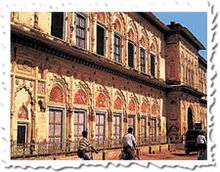
In the Government Museum there are collections of weapons, statues, dresses and photographs that represent the Chandela dynasty and a picture gallery of the Gupta period. There are also terracottas, bronzes, manuscripts, paintings and coins.Government museum specifically keep the belonging of rani of jhansi, example: her sword, armour and utensils. The museum is closed on Mondays and second Saturday of every month.
The Rani Mahal was the palace of Rani Lakshmi Bai and has now been converted into a museum. It houses a collection of archaeological remains of the period between the 9th and 12th centuries AD.
An engineering college named as Bundelkhand Institute of Engineering & Technology an state govt engineering college
Other places of interest
Temples: Iskcon Temple, Laxmi Temple; Shri Kali Temple; Karguan Jain Temple.--Christian churches: St. Jude's Shrine; St Antony's Cathedral.--Gangadhar Rao-Ki-Chhatri (tomb).--Laxmi Bai Park; Narayan Bagh; Jari Ka Math; Barua Sagar & Fort; Garhmau Lake; Herbal Garden.
Education
Higher education
- Modern Group of Institutions, Jhansi
- Modern College, Jhansi
- Kamla Modern Nursing Institute, Jhansi
- Rani Lakshmi Bai Central Agricultural University
- Bundelkhand University
Medical and Technical Colleges

Maharani Laxmi Bai Medical college Hospital Jhansi was established in 1968, is named after the "Jhansi ki Rani" Maha Rani Laxmi Bai. The college admits 100 students each year for medical course and nearly 54 post graduate student in various specialties.
- Maharani Laxmi Bai Medical College[15]
- Bundelkhand Govt. Ayurvedic College & Hospital
In October 2009, the Union health ministry had given approvals for setting up an institute equivalent to AIIMS, the first in bundelkhand region and developing central agriculture university.[16]
- Bundelkhand Institute of Engineering & Technology
- Institute of Engineering and Technology, Bundelkhand University.

- Government Polytechnic Jhansi[17]
- Rani laxmibai central agriculture university jhansi
- SR Group of Institutions, Ambabai,Jhansi
Research institutes
- ICAR-Indian Grassland & Fodder Research Institute (IGFRI)
- ICAR-Central Agro-Forestry Research Institute (CAFRI)
Schools
Private

- Modern Public School, Lalitpur
- Modern Public School, Kanpur Road, Jhansi
- Modern Public School, Jhokan Bagh, Jhansi
- Christ the King College
- St. Francis College, Jhansi
Government
- Kendriya Vidyalaya No.1[18] (Rana Pratap Marg, Jhansi Cantt, Jhansi)
- Kendriya Vidyalaya No.2[19] (Near St. Martin Church, Cariappa Marg, Jhansi Cantt, Jhansi)
- Kendriya Vidyalaya No.3[20] (Gulam Gaus Marg, Railway Colony(W), Jhansi)
- Suraj Prasad Govt Girls Inter College,sadar bazar
- Hafiz siddiqui inter college,Jhansi
Transport
The city is well connected to other parts of India by railways and major highways.
Railways
Jhansi Junction has its own Division of the Indian North Central Railways. It is well connected by train services to all parts of the country, including four metropolitan cities. There are direct trains to Mumbai, madurai, Delhi, Kolkata (Howrah), Chennai, Bangalore (Bengaluru), Visakhapatnam, Hyderabad, Nagpur, Agra Gwalior, Trivandrum, Indore, Ahmedabad, Udaipur, Pune, Jammu, Jaipur, Lucknow, Bhopal, Mahoba, Khajuraho, Gaya, Jalgaon, Bhusaval, Jabalpur, Kanpur, Allahabad, Gorakhpur, Bandra and other major towns. A list of all train services passing through Jhansi Junction can be found here.[21]
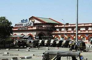
Jhansi Junction is a major railway junction of Indian Railways: a major intercity hub and a technical stoppage for many superfast trains in India. Jhansi has its own division in the North Central Railway zone of Indian Railways. It lies on the main Delhi-Chennai and Delhi-Mumbai lines. The station code is JHS.
History
The railway station was built by the British in the late 1880s. After a long survey of three places the current site was selected for the station. The station has a massive fort-like building painted in maroon and off white.
The station had three platforms in the beginning. Platform One is 2,525 feet (770 m) long making it the seventh longest in the world so could easily handle two trains at a time. Platforms two and three are also long enoungh to do this. The first Shatabdi Express of India started between New Delhi and Jhansi. Earlier Jhansi used to be a part of Central railways zone headquartered at Mumbai but now comes under NCR headquartered at Allahabad.

Connectivity
Jhansi Junction is linked with many industrial and important cities of India by direct trains like New Delhi, Kanpur, Lucknow, Bhopal, Chennai, Bangalore, Hyderabad, Mumbai, Kolkata, Jammu, Agra, Bhubaneshwar, Ahmedabad, etc.
Jhansi Junction is served by 4 broad gauge routes:
- Jhansi - New Delhi
- Jhansi - Kanpur Central
- Jhansi - Bhopal
- Jhansi - Manikpur
- Jhansi - Shivpuri (proposed)
There is an ongoing survey for a new line between Jhansi Junction and Shivpuri in Madhya Pradesh which would be further connected to Sawai Madhopur and Jaipur.
Many prestigious Indian Railways trains origins/pass through Jhansi, including the 12279/Taj Express, 11105/Pratham Swatantrata Sangram Express, Tamil Nadu Express, Kerala Express, Andhra Pradesh Express, Bhopal Express, Dakshin Express and Pushpak Express.
Jhansi is an important destination for tourists intending to go to Khajuraho (a UNESCO World Heritage Site) and to Orchha.
There are escalators in the Jhansi junction railway station for elderly or incapacitated passengers.
Facilities
Jhansi Junction has 7 platforms, 4 broad over-bridges. Due to heavy usage, two new platforms are planned, increasing the total to 11. Five pairs of the Rajdhani Express as well as the Bhopal — New Delhi Shatabdi Express pass through Jhansi.Three pairs of Duronto Express also have their technical stoppages at Jhansi. All state Sampark Krantis passing through Jhansi have official stops at Jhansi. In all more than 150 trains stop at Jhansi Junction everyday.
The station also features a restaurant, air-conditioned and non-air-conditioned waiting rooms, a cyber cafe, and tourist information offices of both the Madhya Pradesh and Uttar Pradesh governments. Outside the station also there is a passenger complex and canteen.
Road transport
Jhansi is located at the junction of these National Highways: NH-12A; NH-25; NH-26; NH-75; and NH-76. Thus, Jhansi commands a strategic position in the roadways network as highways in 5 different directions diverge from it.
And go near towns and major cites in all over India these are Datia, Gwalior, Lalitpur, Agra, New Delhi, Bhopal, Allahabad, Kanpur, Orchha, Shivpuri, Tikamgarh, Unnao Balaji, Sagar
The proposed north-south and east-west corridors of the Golden-Quadrilateral Highway project pass and cross each other only in Jhansi and the city is also well connected to Kanpur, Lucknow and Madhya Pradesh by road. The four lane national highway is at the last stage of its completion, giving a boom in infrastructure and other sectors in Jhansi and nearby areas; the greenery near this highway is attractive.
Air transport

Jhansi Airport is a military aviation base built in the British era used by the Indian army and political visitors. Though there are provisions for private aircraft to land, there are no civil aviation operations. There had been a demand to make it operational for commercial purposes in the 1990s and again in the 2000s. The Uttar Pradesh government announced the construction of an all new civil aviation base to support tourism in Bundelkhand in April 2011.[22] The Indian army maintains an objection to extension of the military aviation. So, the government has examined three different places other than army aviation base for the airport in Jhansi. Gwalior Airport is the nearest airport from Jhansi.
Media
Newspapers
Many national and local newspapers are published in Jhansi in Hindi, Urdu and English:
| Newspaper | Language | Notes |
|---|---|---|
| Amar Ujala | Hindi | |
| Dainik Jagran | Hindi | |
| Dainik Vishwa Pariwar | Hindi | |
| Daily Aziz E Hindustan | Urdu | |
| Dainik Royal Mail | Hindi | |
| Hindustan | Hindi | |
| Jan Jan Jagran | Hindi | |
| Jan Seva Mail | Hindi | |
| Raftaar | Hindi | |
| Swadesh | Hindi |
Radio
Jhansi has two radio stations: 92.7 BIG FM and 103.0 AIR FM.
Cinema
Jhansi currently has two cinema halls which are operating rest are under construction.
1.Elite Cinema
2.Khilona Cinema
Armed forces
Jhansi district has the headquarters of the 31st Indian Armoured Division of the Indian Army, stationed at Jhansi-Babina. It is an armoured division which has equipment like the T-72 and T-90 tanks, and the BMP-2 armoured personnel carrier.
The Jhansi Cantonment was the site of the accommodation for British civil and military personnel in the period of British rule in India. Within the cantonment is Sacred Heart Church, a Roman Catholic church built early in the 20th century.[23]
Sport
Sports stadiums in Jhansi are Dhyanchand Stadium; Railway Stadium; and LVM Sports Place.
Facilities in Jhansi
Being a junction point of the North-South and East-West corridor,Jhansi has various attractions.
Shopping
Malls in Jhansi
- Vishal Mega Mart,Near Bus Stand
- City Kart ,Jail chouraha
- Reliance trends,Jevanshah Chouraha
- V-Mart ,BKD chouraha
- Culture,Sipri Bazaar
Local Markets
- Sadar Bazar - A place well known for quality products and a whole lot of showrooms selling international brands ,And the most famous and favorite eating hub of the city.
- Sipri Bazar-Another important market of Jhansi ,Loacted at elite-shivpuri road.
- Sheher(City)-This is the part of the old Jhansi city located just at the foothills of the Jhansi Fort,still famous as sheher which city in english.Manik Chowk a place where you will find all electronics and gift items is located here. Sarafa Bazar (Jewellery Market) is also located here. Bada Bazaar a place for all your grocery needs is situated here near Rani Mahal. This place is specifically cheaper than the other two markets listed above and hence is the most crowded one.
Accommodation in Jhansi
Hotels
- Hotel Yatrik
- Hotel Chanda
- Hotel Anand
- Hotel Ambience
- Hotel Shreenath
- Hotel Ambrosia
- Hotel Sheela Shree
- Hotel Sita
- Hotel Samrat
- Jhansi Hotel
- Hotel Prakash Regency
- Hotel Bundelkhand Pride
- Hotel Veerangana
- Hotel Rishabh
- Hotel Tulsi
Notable people associated with Jhansi
- Maharaja Gangadhar Rao, raja of Jhansi State, 1838–53
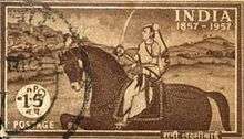
- Rani Lakshmibai, queen consort of Maharaja Gangadhar Rao; regent and afterwards queen who led her people in defence of the city against British forces in 1858
- Chandra Shekhar Azad, Indian freedom fighter
- Major Dhyan Chand, Indian Army officer and hockey player for the national team of India
- Maithili Sharan Gupt, one of the most prominent Hindi poets, also known as Rashtrakavi, was born in Chirgaon.
- Amit Singhal, senior vice-president at Google Inc.,responsible for developing Google search Algorithm[24]
- Abdul Karim (the Munshi), an Indian Muslim attendant of Queen Victoria who served her during the final 15 years of her reign, gaining her maternal affection over that time
- Ashok Dhyanchand, former player of Indian national hockey team.
- Dr Saumitra Rawat, an eminent surgeon, Chairman and Head, Surgical Gastroenterology and Liver Transplant, Sir Ganga Ram Hospital, New Delhi. The Government of India honoured him in 2015 with the award of Padma Shri.
- Tushar Khandekar, player of Indian national hockey team.
- Vrindavan Lal Verma,eminent Hindi novelist and playwright was born in Mauranipur
Jhansi in literature
Two novels by John Masters are set in the fictional town of Bhowani. According to the author, writing in the Glossary to the earlier novel, Nightrunners of Bengal, Bhowani is an "imaginary town. To get a geographical bearing on the story it should be imagined to be about where Jhansi really is - 25.27 N., 78.33 E."[25] Nightrunners of Bengal is set during the Indian Rebellion of 1857 at "Bhowani" (the title alludes to the mysterious distribution of "chapatis" to village headmen which preceded the revolt). Bhowani Junction is set in 1946/47 the eve of independence. In each novel the main character is a British army officer named Colonel Rodney Savage, one of a succession of such men from the same family.
Christina Rossetti wrote a short poem about the fate of the Skene family at Jhansi during the Indian Mutiny. It is entitled 'In the Round Tower at Jhansi - 8 June 1857'. It was published in 1862 in the same volume as her more celebrated poem 'Goblin Market'. Some time afterwards, Rossetti discovered that she had been misinformed about the husband and wife's suicide pact in the face of a murderous and implacable enemy ('The swarming howling wretches below' the tower walls) which is the poem's subject, but did not delete it from later editions.
See also
References
- ↑ "CONTACT DETAILS OF COMMISSIONERS AND MAYORS OF AMRUT CITIES" (PDF). Atal Mission for Rejuvenation and Urban Transformation.
- ↑ https://uppolice.gov.in/frmPPSOfficerprofile.aspx?transid=653&slugName=jhansi
- 1 2 3 "Jhansi City Census 2011 data". Census 2011 - Census of India.
- ↑ "Uttar Pradesh plans to develop Jhansi airport". igovernment.in. 4 January 2011. Archived from the original on 21 March 2012. Retrieved 3 September 2015.
- ↑ "Centre unveils list of 98 smart cities; UP, TN strike it rich". The Hindu. 28 August 2015.
- ↑ "Smart City Jhansi". Mygov.in. Retrieved 2016-06-24.
- ↑ "स्मार्ट सिटी की परीक्षा में फेल हुए यूपी के 12 शहर". Amar Ujala. 30 January 2016.
- 1 2 3 "Jhansi City Census 2011 data". 2011 Census of India.
- ↑ "Census of India 2001: Data from the 2001 Census, including cities, villages and towns (Provisional)". Census Commission of India. Archived from the original on 16 June 2004. Retrieved 20 February 2013.
- ↑ "Jhansi, India Page". fallingrain.com. Retrieved 3 September 2012.
- ↑ The Macmillan Encyclopedia; rev. ed. London: Macmillan, 1983; p. 647
- ↑ Moore, W. G. (1971) The Penguin Encyclopedia of Places. Harmondsworth: Penguin; p. 371
- ↑ "Jhansi Climatological Table Period: 1971–2000". India Meteorological Department. Retrieved April 15, 2015.
- ↑ "Ever recorded Maximum and minimum temperatures up to 2010" (PDF). India Meteorological Department. Archived from the original (PDF) on 21 May 2013. Retrieved April 15, 2015.
- ↑ "Maharani Laxmibai Medical College Jhansi". Mlbmcj.in. Retrieved 2016-06-24.
- ↑ "Centre clears an AIIMS for Bundelkhand". Archive.indianexpress.com. Retrieved 23 August 2015. C1 control character in
|title=at position 18 (help) - ↑ "Archived copy". Archived from the original Check
|url=value (help) on 9 January 2014. Retrieved 30 December 2013. - ↑ "Kendriya Vidyalaya No.1 Jhansi :: Home Page". Kv1jhansi.org. Retrieved 2016-06-24.
- ↑ "wel come to kendriya vidyalaya no-2 jhansi". Kv2jhansi.org.in. 2016-05-13. Retrieved 2016-06-24.
- ↑ "Welcome|Kendriya Vidyalaya Jhansi-3|". Web.archive.org. Archived from the original on 10 January 2009. Retrieved 2016-06-24.
- ↑ "JHS/Jhansi Junction (7 PFs) Railway Station - Train Departure Timings". India Rail Info. Retrieved 2016-06-24.
- ↑ Manjul, Tarannum (1 April 2011). "New airport at Jhansi to boost tourism". indianexpress. Retrieved 3 September 2012.
- ↑
- ↑ "Amit Singhal's journey from Jhansi to Google". CNN-IBN. 4 February 2016.
- ↑ Masters, John. Nightrunners of Bengal. (London and New York, 1951). Glossary.
External links
| Wikimedia Commons has media related to Jhansi. |
-
 Jhansi travel guide from Wikivoyage
 - Official website