Jewell Island (Maine)
Jewell Island is a small island in Casco Bay, Maine, United States. About 1 mile (1.6 km) long from SW to NE, it is located off the coast of Cliff Island, an approximate 8-mile boat ride from downtown Portland, Maine. It is a state-owned island with a small but protected harbor as well as camping and walking paths. There are also World War II fire control towers on the island. Cocktail Cove is popular for kayaking and the Punchbowl located in the north east area of the island. The island is part of the city of Portland. Jewell Island can be reached by private boat any number water taxis including the Portland Express Water Taxi,[1] and Atlantic Water Taxi [2] And
Casco Bay Water Taxi [3]
The island is rich in legend — tales are told of Captain Kidd cruising its coast and hiding treasure. The World War II bunkers are said to be haunted by soldiers, and the beaches by bootleggers. Several accounts of ghostly encounters can be heard in local towns.
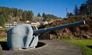
During World War II the island included the Jewell Island Military Reservation. Three coastal artillery gun batteries were constructed on the island. The largest, although never completed, was Battery Construction Number (BCN) 202. It was designed for two 6-inch guns in shielded mounts that would be on the large concrete circles at each end of the battery. Positions for two Anti-Motor Torpedo Boat (AMTB) batteries with 90 mm guns were also constructed on Jewell Island. Each battery was authorized four 90 mm guns, two on fixed mounts and two on towed mounts. The guns were dual-purpose, able to fire against air or surface targets. The batteries were designated AMTB 967 and AMTB 968. The World War II construction was part a modernization of the Harbor Defenses of Portland, centered on Battery Steele on Peaks Island, which the fire control towers and SCR-296 radar on Jewell Island supported.[4][5][6]
See also
References
External links
Coordinates: 43°40′53″N 70°05′35″W / 43.6814°N 70.0930°W / 43.6814; -70.0930
|
|---|
|
| Army | | |
|---|
|
| Air Force | |
|---|
|
| Navy | | Naval Air Station | |
|---|
| | Radio Station | |
|---|
| | Shipyard | |
|---|
| | Prison | |
|---|
|
|---|
|
| Coast Guard | | Station |
- Caribou
- Eastport
- Jonesport
- Rockland
- South Portland
|
|---|
|
|---|
|
| National Guard | | Air National Guard Base | |
|---|
| | Air National Guard Station | |
|---|
| | Army National Guard Camp | |
|---|
| | Army National Guard Armory |
- Bangor
- Belfast
- Calais
- Caribou
- Fort Kent
- Gardiner
- Houlton
- Lewiston
- Norway
- Portland
- Sanford
- Skowhegan
- Waterville
- Westbrook
|
|---|
|
|---|