Jervis Bay
| Jervis Bay | |
|---|---|
|
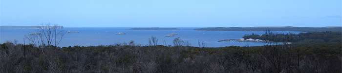
Jervis Bay looking through the heads, with 10 Royal Australian Navy ships at anchor, on 6 February 2006. Visible on the horizon are Bowen Island and Point Perpendicular. | |
 Jervis Bay Location off the coast of New South Wales | |
|
Jervis Bay from orbit | |
| Location | Jervis Bay Territory; New South Wales |
| Coordinates | 35°03′55″S 150°44′05″E / 35.06528°S 150.73472°ECoordinates: 35°03′55″S 150°44′05″E / 35.06528°S 150.73472°E[1] |
| Type | Oceanic bay |
| Primary outflows | Tasman Sea |
| Basin countries | Australia |

Jervis Bay (/ˈdʒɑːrvᵻs/ or local /ˈdʒɜːrvəs/)[2][3] is a 102-square-kilometre (39 sq mi)[4] oceanic bay on the south coast of New South Wales, Australia, said to possess the whitest sand in the world.[5]
A 70-square-kilometre (27 sq mi) area of land around the southern headland of the bay is a territory of the Commonwealth of Australia known as the Jervis Bay Territory. The Australian Navy base, HMAS Creswell, is in the Jervis Bay Territory between Jervis Bay Village and Greenpatch Point.
Geography
In the Jervis Bay Territory on the southern side of the bay are the settlements of Greenpatch, Hyams Beach, and Bowen Island. From north to south on the New South Wales shore of the bay are Callala Beach, Callala Bay, Huskisson and Vincentia. Beecroft Peninsula, on the northern side of the bay, has been used as a bombing range by the Australian Navy.[6] Point Perpendicular forms the southern end of the peninsula.
Geology
Jervis Bay is a drowned river valley and formed 15,000 years ago, at the end of the last ice age.[7] The bay took on its present appearance around 4000 BC after the sea levels had risen 120 metres (390 ft), and as sand dune barriers created the southern peninsula.[8] Much of the rock in Jervis Bay is part of the Sydney Basin sandstone formation, which is 280-225 million years old, although lower areas are overlain with Tertiary-era sediments.[8]
Several features at Jervis Bay have been used as evidence that the Australian coast experienced many giant tsunamis prior to European colonisation.[9]
Climate
Jervis Bay experiences an oceanic climate (Köppen climate classification: Cfb), with average maximum temperatures varying from 16 °C in winter to 25 °C in summer tempered by sea breezes. The highest recorded temperature is 42.1 °C in January, and the lowest 4.7 °C in August.
Hot summer evenings are sometimes relieved by a front of rapidly moving cool air known as a southerly buster.
Rainfall is fairly evenly distributed throughout the seasons, with a bias to the first half of the year, due to prevailing easterlies. Short high intensity rainfall events may happen at any time of the year and can lead to local flooding. Jervis Bay also experiences thunderstorms during the warmer months bringing lightning, heavy rain and occasionally hail.
Yearly rainfall is influenced by the El Niño-Southern Oscillation.
| Climate data for Jervis Bay (Point Perpendicular) | |||||||||||||
|---|---|---|---|---|---|---|---|---|---|---|---|---|---|
| Month | Jan | Feb | Mar | Apr | May | Jun | Jul | Aug | Sep | Oct | Nov | Dec | Year |
| Record high °C (°F) | 42.1 (107.8) |
38.3 (100.9) |
34.7 (94.5) |
30.2 (86.4) |
26.1 (79) |
22.9 (73.2) |
24.0 (75.2) |
25.6 (78.1) |
31.2 (88.2) |
35.7 (96.3) |
38.2 (100.8) |
34.1 (93.4) |
42.1 (107.8) |
| Average high °C (°F) | 24.9 (76.8) |
24.3 (75.7) |
23.4 (74.1) |
21.1 (70) |
18.6 (65.5) |
16.6 (61.9) |
15.8 (60.4) |
17.0 (62.6) |
19.3 (66.7) |
21.1 (70) |
22.3 (72.1) |
23.3 (73.9) |
20.6 (69.1) |
| Average low °C (°F) | 18.3 (64.9) |
18.5 (65.3) |
17.4 (63.3) |
15.3 (59.5) |
12.6 (54.7) |
11.0 (51.8) |
9.8 (49.6) |
10.2 (50.4) |
12.0 (53.6) |
13.5 (56.3) |
15.4 (59.7) |
16.7 (62.1) |
14.2 (57.6) |
| Record low °C (°F) | 13.1 (55.6) |
12.6 (54.7) |
12.5 (54.5) |
9.1 (48.4) |
8.2 (46.8) |
5.8 (42.4) |
5.1 (41.2) |
4.7 (40.5) |
6.1 (43) |
7.7 (45.9) |
9.0 (48.2) |
10.5 (50.9) |
4.7 (40.5) |
| Average rainfall mm (inches) | 95.5 (3.76) |
136.9 (5.39) |
107.9 (4.248) |
132.4 (5.213) |
120.0 (4.724) |
156.7 (6.169) |
116.5 (4.587) |
68.1 (2.681) |
59.1 (2.327) |
78.7 (3.098) |
82.3 (3.24) |
77.7 (3.059) |
1,234.2 (48.591) |
| Average rainy days | 11.3 | 13.3 | 12.6 | 14.1 | 10.4 | 12.1 | 10.9 | 8.8 | 9.5 | 11.3 | 12.6 | 12.6 | 139.5 |
| Source: Bureau of Meteorology[10][11] | |||||||||||||
Environment
Some 158 square kilometres (61 sq mi) of the land on both sides of the bay have been identified by BirdLife International as an Important Bird Area (IBA) because the coastal heathland supports the largest sub-population of the endangered eastern bristlebird, isolated from other sub-populations.[12] The Jervis Bay natural environment is protected in the Booderee National Park, Jervis Bay National Park and the Jervis Bay Marine Park.
Jervis Bay has been recorded as having the whitest sand in the world.[13]
History
Archaeological evidence at Lake Burrill, 30 kilometres south of Jervis Bay, shows Aboriginal occupation dating back 20,000 years.[14]
Jervis Bay was sighted by Lieutenant James Cook aboard HMS Endeavour on 25 April 1770 (two days after Saint George's Day) and he named the southern headland Cape St George.[15][16]
In August 1791 Lieutenant Richard Bowen, aboard the convict transport ship Atlantic, part of the Third Fleet, sailed into the bay and named it in honour of Admiral John Jervis, under whom he had served.[15][17] In November 1791 Master Matthew Weatherhead entered the bay aboard the Matilda, which had also been part of the Third Fleet, in order to undertake repairs to the ship.[17]
In mid 1797, survivors of the wreck of the Sydney Cove passed through the area on foot, while undertaking an arduous trek of 600 kilometres in an attempt to get to Port Jackson (Sydney).[17][18]
Explorer George Bass entered the bay on 10 December 1797 and named Bowen Island.[19]
In 1822, Aboriginal people who were displaced by Alexander Berry's takeover of land in the Shoalhaven were moved to Wreck Bay. Smallpox and syphilis significantly reduced local populations.[20]
The land now comprising the Jervis Bay Territory was surrendered by the state of New South Wales to the Commonwealth Government in 1915[21][22] to provide a seaport for the new Federal capital under construction at Canberra, which would be Australia’s only inland capital.[23]
In the late 1960s, Australia's first nuclear power plant was proposed for the area, and a site was prepared. However, the project did not proceed.
Recreation

Jervis Bay is well known for recreational fishing and scuba diving, with tour operators departing from Huskisson and amateurs using boat ramps at bayside towns and camp sites. Popular diving sites include The Labyrinths, Gorgonian Wall, Point Perpendicular, a submerged Fairey Firefly aeroplane, scallop beds, Middle Ground, Ten Fathom Reef, and Bowen Island.[24]
Jervis Bay is also known for whale watching, because whale migration, both north and south, can be observed as the animals pass the entrance to the bay, frequently entering the sheltered waters to rest. The majority of whales sighted at Jervis Bay are humpbacks, which migrate along Australia's east coast from June to November. Southern right whales are also showing a slow but steady increase in recent years as they re-colonize former habitats, having been extensively hunted in the 19th and 20th centuries. Other species sighted have been false killer whales, orcas, minke whales and, on one occasion, a blue whale.
Tourism
Tourism in Jervis Bay is one of the most important avenues of income for many of the local residents, with many businesses orienting themselves towards it. The Jervis Bay Visitors Information Centre is at Huskisson, and is part of the Lady Denman Maritime Museum and Gallery.[25] Local Council-managed Visitor Information Centres are at Nowra and Ulladulla.
See also
- Australian Capital Territory
- Beecroft Peninsula
- Booderee National Park
- HMS Jervis Bay
- Jervis Bay National Park
- Jervis Bay Territory
References
| Wikivoyage has a travel guide for Jervis Bay. |
Citations
- ↑ "Jervis Bay (NSW)". Gazetteer of Australia online. Geoscience Australia, Australian Government.
- ↑ Macquarie Dictionary (Fourth ed.). Melbourne: The Macquarie Library Pty Ltd. 2005. ISBN 1-876429-14-3.
- ↑ The Australian Broadcasting Commission Standing Committee on Spoken English; Mitchell, AG; Australian Broadcasting Commission, Missing or empty
|title=(help) - ↑ Crabb 2007, p. 1.
- ↑ Gazing onto the world's whitest sand, SMH, 31 December 2005.
- ↑ Crabb 2007, p. 53.
- ↑ "Jervis Bay Landscape and Geology". NSW National Parks and Wildlife.
- 1 2 Geology and Geomorphology, Wreck Bay Aboriginal Community Council.
- ↑ Bryant, Edward A; Young, RW; Price, DM; Wheeler, DJ; Pease, MI (1997). "The impact of tsunami on the coastline of Jervis Bay, Southeastern Australia". Physical Geography. 18 (5): 440–459.
- ↑ "Jervis Bay (Point Perpendicular) AWS". Climate statistics for Australian locations. Bureau of Meteorology. Retrieved 11 September 2014.
- ↑ "Jervis Bay (Point Perpendicular Lighthouse) (Comparison) AWS". Climate statistics for Australian locations. Bureau of Meteorology. Retrieved 30 March 2016.
- ↑ "IBA: Jervis Bay". Birdata. Birds Australia. Retrieved 13 July 2011.
- ↑ "Gazing onto the world's whitest sands". Sydney Morning Herald. Fairfax Media. 1 January 2006. Retrieved 8 July 2011.
- ↑ "Aboriginal culture and history". Department of Environment, Government of Australia. Retrieved 16 March 2016.
- 1 2 Reed 1973
- ↑ Crabb 2007, p. 4.
- 1 2 3 Crabb 2007, p. 5.
- ↑ "The Sydney Cove". http://www.parks.tas.gov.au/. Parks and Wildlife Service Tasmania. Retrieved 31 August 2014. External link in
|website=(help) - ↑ Crabb 2007, p. 6.
- ↑ "Jervis Bay Territory History". Department of Infrastructure and Regional Development, Government of Australia. Retrieved 16 March 2016.
- ↑ Jervis Bay Territory Acceptance Act 1915 (Cth)
- ↑ "Seat of Government Surrender Act (NSW) Act 9 of 1915". This document, assented to by the Governor-General in 1915, provided for the transfer of 28 square miles of land at Jervis Bay to the Commonwealth, in addition to the areas surrendered under the Seat of Government Acceptance Act 1909 and the Seat of Government Surrender Act 1909. Museum of Australian Democracy. Retrieved 17 January 2013.
- ↑ "Map Showing Jervis Bay and the Most Suitable Area for Commonwealth Purposes". Documenting a Democracy. Museum of Australian Democracy. Retrieved 2014-07-07.
- ↑ "Jervis Bay". VisitNSW.com. Retrieved 17 January 2013.
- ↑ "Lady Denman Heritage Complex". Lady Denman Heritage Complex. Retrieved 17 January 2013.
Sources
- Byron, Tom (1985). Scuba Divers Guide to Jervis Bay. Aqua Sports. ISBN 978-0949490025.
- Barker, A (1996). What Happened When. Sydney: Allen & Unwin. ISBN 1-86373-986-6.
- Crabb, Peter (2007). The Jervis Bay Region 1788 to 1939 an Emptied Landscape. Huskisson: Lady Denman Heritage Complex. ISBN 0-958644-7-3X.
- Reed, AW (1973). Place Names of Australia. Sydney: Reed Books. ISBN 978-0-589-07115-8.