Jerusalem Governorate
| |||

The Jerusalem Governorate (Arabic: محافظة القدس Muḥāfaẓat al-Quds; Hebrew: נפת אל קודס Nafat al-Quds) is one of the 16 Governorates of Palestine and located in the central part of the West Bank. The Governorate has two sub-districts: Jerusalem J1, which is includes the localities within the Israeli Jerusalem municipality (East Jerusalem), and Jerusalem J2, which includes the remaining parts of the Jerusalem Governorate.[1] The district capital of the Governorate is Jerusalem (al-Quds).
The total land area of the governorate is 344 km2. According to the Palestinian Central Bureau of Statistics, the governorate had a population of 429,500 residents in 2005, accounting for 10.5% of Palestinians living in the Palestinian territories.[2] Adnan al-Husayni was appointed governor in 2008.
Division
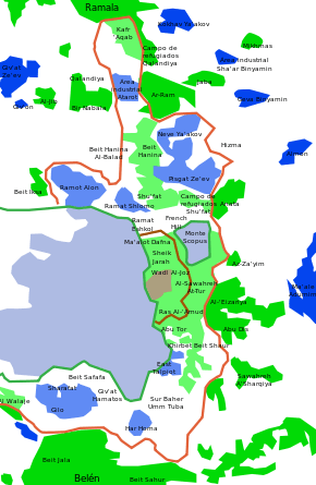
The Jerusalem Governorate is divided into the sub-districts "Jerusalem J1" and "Jerusalem J2". Jerusalem J1 comprises the parts of the West Bank that were annexed by Israel in 1980 and included within the Israeli municipality Jerusalem. Jerusalem J1 is usually referred to as East Jerusalem. Jerusalem J2 comprises the parts of the Governorate that are not included in J1.[1]
Division by sub-district
Jerusalem J1: Al-Isawiya, Al-Quds (Old City), Ash-Shayyah, As-Sawahira Al-Gharbiya, As-Suwwana, At-Tur, Ath-Thuri, Bab As-Sahira, Beit Hanina, Beit Safafa, Jabal Al-Mukabbir, Kufr A’qab, Ras Al-Amud, Sharafat, Sheikh Jarrah, Shu’fat, Shu'fat Refugee Camp, Silwan, Sur Baher, Umm Tuba, Wadi Al-Joz
Jerusalem J2: Abu Dis, Al-Eizariya, Al-Jib, Al-Judeira, Al-Qubeiba, Al-Ram, As-Sawahira ash-Sharqiya, 'Anata, An-Nabi Samwil, Ash-Sheikh Sa’d, Az-Za’eem, Beit Anan, Beit Hanina al-Balad, Beit Ijza, Beit Iksa, Beit Surik, Biddu, Beit Duqqu, Bir Nabala, Dahiat Al-Bareed, Hizma, Jaba’, Khirbet Umm Al-Lahem, Mikhmas, Qalandya, Qalandya Refugee Camp, Qatanna, Rafat, the Bedouin community Al-Khan Al-Ahmar, the Bedouin community Jaba’, other Bedouin communities (see Bedouin village 'Arab al-Jahalin).
Division by locality type
.svg.png)
Cities
Municipalities
Village councils
- 'Anata
- Arab al-Jahalin
- Beit 'Anan
- Beit Duqqu
- Beit Hanina
- Beit Iksa
- Beit Sirik
- Jaba'
- Al-Jib
- Al-Judeira
- Kalandia
- Mikhmas
- Rafat
- As-Sawahira ash-Sharqiya
- Az-Za'ayyem
East Jerusalem neighborhoods
- Abu Tor
- Beit Hanina
- Beit Safafa
- Isawiya
- Jabal Mukabar
- Old City
- Ras al-Amud
- Sheikh Jarrah
- Shu'fat
- Silwan
- Sharafat
- Sur Baher
- At-Tur
- Umm Tuba
- Wadi al-Joz
- Al-Walaja (part of Bethlehem Governorate and East Jerusalem)
Politics

After the 1948 Arab–Israeli War, Jerusalem was divided. West Jerusalem came under Israeli rule and East Jerusalem, including the Old City, was ruled by Jordan until 1967. In the 1967 Six-Day War, Israel occupied the West Bank and unified the two parts of the city. East Jerusalem, along with other parts of the West Bank and West Jerusalem, were incorporated in one municipality. However, according to an agreement between the PLO and Israel, East Jerusalem's Palestinian residents that wish so are allowed to participate in the PNA elections, and those that have taken up Israeli citizenship can vote in the elections for the Knesset, Israel's parliament, as well.
See also
References
- 1 2 Israeli Settlements in Palestine—Annual Statistical Report 2012, Concepts and Definitions, pp. [22]-[23]. Palestinian Central Bureau of Statistics, August 2013
- ↑ Jerusalem Bulletin English.pdf
External links
- Jerusalem governorate List of residential gatherings. Palestinian National Information Centre, 1999. On web.archive.org

Coordinates: 31°48′N 35°18′E / 31.8°N 35.3°E