Jemmape (department)
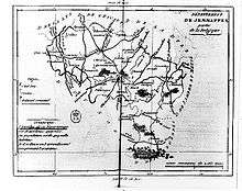
Jemmape was a department of the First French Empire in present-day Belgium. It was named after the Battle of Jemappes, fought between the French and the Austrians in 1792 near the village of Jemappes, near Mons. Jemappes was spelled Jemmape, Jemmapes or Jemmappes at the time. Its territory corresponded more or less with that of the Belgian province of Hainaut. Its capital was Mons.
The department came into existence in 1795, when the Southern Netherlands were occupied by the French. It was formed from most of the County of Hainaut, Tournai and the Tournaisis, a part of the county of Namur (Charleroi) and of the Bishopric of Liège (Thuin).
The department was subdivided into the following arrondissements and cantons (situation in 1812):[1]
- Mons, cantons: Boussu, Chièvres, Dour, Enghien, Lens, Le Roeulx, Mons (2 cantons), Pâturages and Soignies.
- Charleroi, cantons: Beaumont, Binche, Charleroi (2 cantons), Chimay, Fontaine-l'Évêque, Gosselies, Merbes-le-Château, Seneffe and Thuin.
- Tournai, cantons: Antoing, Ath, Celles, Ellezelles, Frasnes, Lessines, Leuze, Péruwelz, Quevaucamps, Templeuve and Tournai (2 cantons).
Its population in 1812 was 472,366, and its area was 376,658 hectares.[1]
After Napoleon was defeated in 1814, the department became part of the United Kingdom of the Netherlands as the province of Hainaut.
References
- 1 2 Almanach Impérial an bissextil MDCCCXII, p. 415-416, accessed in Gallica 25 July 2013 (French)
Coordinates: 50°27′N 3°53′E / 50.450°N 3.883°E