Jeffersonville, Georgia
| Jeffersonville, Georgia | |
|---|---|
| City | |
|
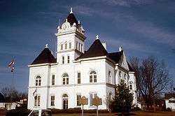
Twiggs County Courthouse (built 1903), Jeffersonville, Georgia | |
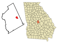 Location in Twiggs County and the state of Georgia | |
| Coordinates: 32°41′2″N 83°20′23″W / 32.68389°N 83.33972°WCoordinates: 32°41′2″N 83°20′23″W / 32.68389°N 83.33972°W | |
| Country | United States |
| State | Georgia |
| County | Twiggs |
| Area | |
| • Total | 3.7 sq mi (9.5 km2) |
| • Land | 3.7 sq mi (9.5 km2) |
| • Water | 0 sq mi (0 km2) |
| Elevation | 518 ft (158 m) |
| Population (2010) | |
| • Total | 1,035 |
| Time zone | Eastern (EST) (UTC-5) |
| • Summer (DST) | EDT (UTC-4) |
| ZIP code | 31044 |
| Area code(s) | 478 |
| FIPS code | 13-42100[1] |
| GNIS feature ID | 0356333[2] |
The city of Jeffersonville is the county seat of Twiggs County, Georgia, United States.[3] The population was 1,035 at the 2010 census, down from 1,209 at the 2000 census.
Jeffersonville is part of the Macon Metropolitan Statistical Area.
History
The city was named after President Thomas Jefferson,[4] or, according to another source, the Jefferson family of settlers.[5]
Geography
Jeffersonville is located at 32°41′2″N 83°20′23″W / 32.68389°N 83.33972°W (32.683982, -83.339683).[6]
According to the United States Census Bureau, the city has a total area of 3.7 square miles (9.6 km2), all of it land.
Demographics
| Historical population | |||
|---|---|---|---|
| Census | Pop. | %± | |
| 1880 | 156 | — | |
| 1910 | 740 | — | |
| 1920 | 842 | 13.8% | |
| 1930 | 692 | −17.8% | |
| 1940 | 804 | 16.2% | |
| 1950 | 787 | −2.1% | |
| 1960 | 1,013 | 28.7% | |
| 1970 | 1,302 | 28.5% | |
| 1980 | 1,473 | 13.1% | |
| 1990 | 1,545 | 4.9% | |
| 2000 | 1,209 | −21.7% | |
| 2010 | 1,035 | −14.4% | |
| Est. 2015 | 1,050 | [7] | 1.4% |
As of the census[1] of 2000, there were 1,209 people, 436 households, and 320 families residing in the city. The population density was 328.8 people per square mile (126.8/km²). There were 496 housing units at an average density of 134.9 per square mile (52.0/km²). The racial makeup of the city was 36.72% White, 62.37% African American, 0.25% Native American, 0.17% Asian, 0.08% from other races, and 0.41% from two or more races. Hispanic or Latino of any race were 2.73% of the population.
There were 436 households out of which 28.2% had children under the age of 18 living with them, 45.2% were married couples living together, 23.9% had a female householder with no husband present, and 26.6% were non-families. 23.9% of all households were made up of individuals and 9.6% had someone living alone who was 65 years of age or older. The average household size was 2.67 and the average family size was 3.18.
In the city the population was spread out with 25.0% under the age of 18, 10.1% from 18 to 24, 28.8% from 25 to 44, 23.9% from 45 to 64, and 12.2% who were 65 years of age or older. The median age was 36 years. For every 100 females there were 85.1 males. For every 100 females age 18 and over, there were 82.1 males.
The median income for a household in the city was $25,000, and the median income for a family was $37,500. Males had a median income of $29,722 versus $21,042 for females. The per capita income for the city was $13,021. About 17.4% of families and 21.4% of the population were below the poverty line, including 30.9% of those under age 18 and 21.2% of those age 65 or over.
Education
Twiggs County School District
The Twiggs County School District holds pre-school to grade twelve, and consists of four elementary schools (two include pre-school programs), a middle school and a high school.[9] The district has 100 full-time teachers and over 1,489 students.[10]
- Jeffersonville Elementary
- Twiggs Middle School
- Twiggs County High School
Private education
References
- 1 2 "American FactFinder". United States Census Bureau. Retrieved 2008-01-31.
- ↑ "US Board on Geographic Names". United States Geological Survey. 2007-10-25. Retrieved 2008-01-31.
- ↑ "Find a County". National Association of Counties. Retrieved 2011-06-07.
- ↑ "Profile for Jeffersonville, Georgia". ePodunk. Retrieved 2010-06-14.
- ↑ Hellmann, Paul T. (May 13, 2013). Historical Gazetteer of the United States. Routledge. p. 234. Retrieved 30 November 2013.
- ↑ "US Gazetteer files: 2010, 2000, and 1990". United States Census Bureau. 2011-02-12. Retrieved 2011-04-23.
- ↑ "Annual Estimates of the Resident Population for Incorporated Places: April 1, 2010 to July 1, 2015". Retrieved July 2, 2016.
- ↑ "Census of Population and Housing". Census.gov. Retrieved June 4, 2015.
- ↑ Georgia Board of Education, Retrieved June 29, 2010.
- ↑ School Stats, Retrieved June 29, 2010.
| Principal cities | 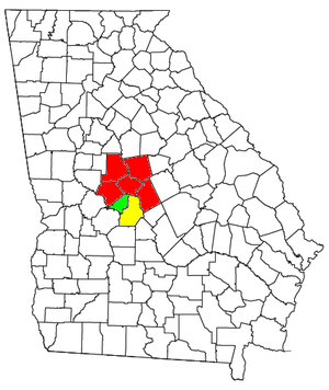 | |
|---|---|---|
| Municipalities | ||
| Other communities | ||
| Counties | ||
| CSA components |
| |
Municipalities and communities of Twiggs County, Georgia, United States | ||
|---|---|---|
| City | 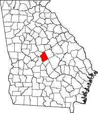 | |
| Towns | ||
| Unincorporated community | ||
| Footnotes | ‡This populated place also has portions in an adjacent county or counties | |