Jecheon
| Jecheon 제천시 | ||
|---|---|---|
| Municipal City | ||
| Korean transcription(s) | ||
| • Hangul | 제천시 | |
| • Hanja | 堤川市 | |
| • Revised Romanization | Jecheon-si | |
| • McCune-Reischauer | Chech'ŏn-si | |
 | ||
| ||
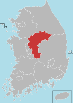
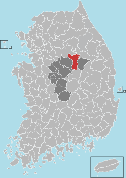 Location in South Korea | ||
| Country |
| |
| Region | Hoseo | |
| Administrative divisions | 1 eup, 7 myeon, 9 dong | |
| Area | ||
| • Total | 882.47 km2 (340.72 sq mi) | |
| Population (2011.01.04) | ||
| • Total | 137,147 | |
| • Density | 157.3/km2 (407/sq mi) | |
| • Dialect | Chungcheong | |
| Area code(s) | (+82) 43-6xx | |

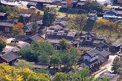
Jecheon is a city in North Chungcheong Province, South Korea. The city is a major railway junction or a transportation mecca, served by the Jungang, Chungbuk and Taebaek Lines. Jecheon has scenic surroundings and several tourist spots like the Uirimji Reservoir, Cheongpung Lake and Cheongpung Cultural Properties Complex. It is also the home of Semyung University.
The city's name derives from the Korean words Je(堤), which means Dam, and cheon(川) which means River.
Location
Jecheon City is located in the northern part of North Chungcheong Province bordering Mungyeong City to the south, while Wonju City and Yeongwol-gun, which are located in Gangwon Province, are to the north. It is well known for its beautiful mountains and lake environments.[1] Jecheon is well known as the "healing city". A wide variety of oriental medicine are available, attracting people all over Korea to visit the city.
Climate
| Climate data for Jecheon (1981–2010) | |||||||||||||
|---|---|---|---|---|---|---|---|---|---|---|---|---|---|
| Month | Jan | Feb | Mar | Apr | May | Jun | Jul | Aug | Sep | Oct | Nov | Dec | Year |
| Average high °C (°F) | 1.3 (34.3) |
4.4 (39.9) |
10.3 (50.5) |
18.2 (64.8) |
23.1 (73.6) |
26.8 (80.2) |
28.4 (83.1) |
29.2 (84.6) |
25.0 (77) |
19.4 (66.9) |
11.1 (52) |
4.0 (39.2) |
16.8 (62.2) |
| Daily mean °C (°F) | −5.2 (22.6) |
−2.3 (27.9) |
3.5 (38.3) |
10.5 (50.9) |
16.0 (60.8) |
20.6 (69.1) |
23.4 (74.1) |
23.8 (74.8) |
18.4 (65.1) |
11.4 (52.5) |
4.1 (39.4) |
−2.4 (27.7) |
10.2 (50.4) |
| Average low °C (°F) | −11.2 (11.8) |
−8.4 (16.9) |
−2.8 (27) |
2.9 (37.2) |
9.2 (48.6) |
15.0 (59) |
19.5 (67.1) |
19.6 (67.3) |
13.3 (55.9) |
5.0 (41) |
−1.7 (28.9) |
−8.0 (17.6) |
4.4 (39.9) |
| Average precipitation mm (inches) | 24.7 (0.972) |
29.4 (1.157) |
56.0 (2.205) |
76.1 (2.996) |
102.1 (4.02) |
154.2 (6.071) |
373.5 (14.705) |
293.7 (11.563) |
161.1 (6.343) |
51.5 (2.028) |
42.4 (1.669) |
23.0 (0.906) |
1,387.8 (54.638) |
| Average precipitation days (≥ 0.1 mm) | 7.2 | 6.9 | 8.9 | 7.8 | 8.4 | 9.3 | 15.6 | 13.9 | 8.8 | 5.4 | 7.4 | 7.4 | 107 |
| Average relative humidity (%) | 69.4 | 66.4 | 63.8 | 58.1 | 64.0 | 69.6 | 78.5 | 77.1 | 75.3 | 72.8 | 70.9 | 71.1 | 69.8 |
| Mean monthly sunshine hours | 165.1 | 163.4 | 193.0 | 216.1 | 231.3 | 211.7 | 160.6 | 181.8 | 176.9 | 194.5 | 153.8 | 154.4 | 2,204.6 |
| Source: Korea Meteorological Administration[2] | |||||||||||||
Sister cities
 Seocho-gu, Korea
 Spokane, Washington, United States
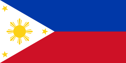 Pasay City, Philippines
 Hualien, Taiwan (2012.09.14)
See also
References
- ↑ Official page
- ↑ "평년값자료(1981–2010) 제천(221)". Korea Meteorological Administration. Retrieved 2011-05-01.
External links
Coordinates: 37°08′N 128°13′E / 37.133°N 128.217°E