Jebel Akhdar, Libya

The Jebel Akhdar (Arabic: الجبل الأخضر al-Jabal al-Akhḍar, English: The Green Mountain) is a heavily forested, fertile upland area in northeastern Libya. It is located in the modern shabiyahs or districts of Derna, Jabal al Akhdar, and Marj.
Geography
The Jebel Akhdar consists of a mountainous plateau rising to an altitude of 900 metres (3,000 ft), cut by several valleys and wadis. It lies northeast of Benghazi and south of Derna and the Mediterranean Sea, it extends along the coast for about 100 miles (160 km). The region is one of the very few forested areas of Libya, which taken as a whole is one of the least forested countries on Earth. It is the wettest part of Libya, receiving some 600 millimetres (24 in) of precipitation annually.[1]
The high rainfall contributes to the area's large forests containing Chammari, and enables rich fruit, potato, and cereal agriculture, something of a rarity in an arid country like Libya.[2] Camels, goats and sheep are herded in and around the Jebel Akhdar and the herders tend to be nomadic.[1]
History
Ancient

Documents created during the New Kingdom of Egypt record that to the west there were large populations of metal workers who lived in towns and had plentiful livestock. The only plausible location for these "Libyans" is the Jebel Akhdar.[3]
The ancient Greek colony of Cyrene was located in a lush valley in the Jebel Akhdar, with the ruins remaining.[4] It was the Greeks who introduced farming to the Jebal Akhdar when they colonised its verdant valleys in around 600 BC.[2]
Italian occupation
During the Italian occupation these mountains were identified as a promising area for agriculture and many Italians moved here in the 1930s. This settlement was interrupted during World War II and the villages and farms were deserted and were later reoccupied by Libyans. The mountain chain was the site of major battles between the British Commonwealth and the Axis forces during World War II.[1]
Liberation
The Libyan leader Omar Mukhtar used this heavily forested mountainous region to resist the Italian military occupation of Libya as Italian colony for more than twenty years, where he organized and devised strategies for the Libyan resistance against Italian Libya.[5]
See also
| Wikimedia Commons has media related to Jebel Akhdar. |
- Mediterranean dry woodlands and steppe – lower elevations
- Mediterranean woodlands and forests – higher elevations
Photo gallery
 Almost in the middle of Jebel Akhdar, (The outskirts of the city of Bayda).
 Eastern end of Jebel Akhdar, (near Derna).
 Marj escarpment area.
 Al Bakour escarpment area.
 Al Bakour at the western end of Jebel Akhdar, near Taucheira).
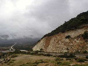
 A severe deforestation of Jebel Akhdar (near Wadi el Kuf Bridge).
References
- 1 2 3 "Akhdar Mountains". Encyclopedia Britannica. Retrieved 2016-11-27.
- 1 2 "Cyrenaica at 1300m". Hidden Journeys. Retrieved 2016-11-27.
- ↑ Peter Mitchell; Paul Lane (2013). The Oxford Handbook of African Archaeology. Oxford University Press. ISBN 0191626155.
- ↑ "Cyrenaica". Livius. Retrieved 2016-11-27.
- ↑ "A symbol of resistance: Omar Mukhtar". Worldbulletin News. Retrieved 2016-11-27.
Coordinates: 32°35′52″N 21°28′22″E / 32.597734°N 21.472778°E