Jeanne d'Arc Basin
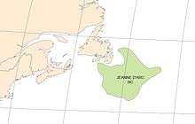


The Jeanne d'Arc Basin is an offshore sedimentary basin located about 340 kilometres (~210 miles) to the basin centre, east-southeast of St. John's, Newfoundland and Labrador. This basin formed in response to the large scale plate tectonic forces that ripped apart the super-continent Pangea and also led to sea-floor spreading in the North Atlantic Ocean. This basin is one of a series of rift basins that are located on the broad, shallow promontory of continental crust known as the Grand Banks of Newfoundland off Canada's east coast. The basin was named after a purported 20 metres (11 fathom) shoal labelled as "Ste. Jeanne d'Arc" on out-dated bathymetric charts [1] and which was once thought to represent a local exposure of basement rocks similar to the Virgin Rocks.[2]
Basin formation
The upper crust beneath the wide shoals of the Grand Banks region is composed of old Precambrian and Paleozoic strata that were moderately deformed by compression during the collisions of ancient continental plates during final assembly of the super-continent Pangea in Devonian to Carboniferous times.[3][4] Later, these old 'basement' rocks were subjected to multiple episodes of stretching during the Mesozoic and the strain of that extension was expressed in growth of large rips in the rock fabric known as faults. The crust was thinned in areas of stretching and the synchronous growth of faults allowed those areas to subside; that is, to sink relative to surrounding areas, thereby creating rift basins. The Jeanne d'Arc Basin is one of these areas of rift subsidence that is bounded and transected by extensional faults which record the plate tectonic history of the North Atlantic region.[5][6]
As the Jeanne d'Arc rift basin subsided, it was gradually in-filled with sediments eroded from adjacent areas of crustal uplift. Characteristics of the sedimentary basin fill and their relationships to the extensional history of the Jeanne d'Arc Basin have been variably described by numerous authors with general agreement on the applicability of rift concepts to the basin.[7] There are, however, divergent conclusions regarding the number of Mesozoic rift episodes which affected the Jeanne d'Arc Basin (i.e. two or three), their ages of initiation and duration, and the orientations of extensional stresses that created different fault sets active during the rift episodes.[8][9][10][11][12][13][14][15][16][17] Rift episodes were followed by initiation of sea-floor spreading first to the south, then to the east, and finally to the northeast of the Grand Banks area.[5] Widely faulted and moderately rotated Upper Triassic to Lower Cretaceous beds within the rift basin were subsequently buried beneath a relatively unstructured cover of Upper Cretaceous and Tertiary strata.[18] These latter minimally deformed strata were deposited on the newly established passive margin.[19] The current passive margin conditions were established when the last rifted border to the three-sided promontory of continental crust underlying the Grand Banks bathymetric feature formed along its northeast margin near the start of Late Cretaceous times.
Geology and hydrocarbon prospectivity
Effective combinations of a number of geological factors must occur for a basin to have generated, trapped and preserved hydrocarbons (oil and/or gas). The nature of the sediments deposited during and after the three rift episodes which affected the Jeanne d'Arc Basin [9][10] and the numerous complex structures formed in response to the changing stress regimes through Mesozoic time have proven critical to the basin's hydrocarbon prospectivity.[19][7] First, large volumes of halite salt of the Argo Formation were precipitated in the basin during the Late Triassic to earliest Jurassic.[20][21][22][15] These salt beds with interbeds of dolomite were precipitated atop and adjacent to continental clastic facies (alluvial plain sandstones and red shales) of the Eurydice Formation. The presence of this thick salt unit throughout the Jeanne d'Arc Basin has been an important factor in subsequent structural deformation and hydrocarbon trap formation during later rift episodes. It provided a widespread interval of low shear strength which acted as a sub-horizontal detachment horizon between vertically stacked zones of strain.[23] Consequently, precipitation of salt during the first Mesozoic rift episode resulted in partial isolation of crustal extension from extension and creation of structural traps of the overlying sedimentary column during subsequent rift episodes recognized in the Jeanne d'Arc Basin.
One element that is absolutely essential for successful exploration and development is the presence of a stratigraphic unit that is capable of hydrocarbon generation. The presence of an excellent quality Upper Jurassic source rock in the Jeanne d'Arc Basin was first identified in well cuttings from the Egret K-36 exploration well.[24] This Kimmeridgian package of organic-rich, thinly interbedded and finely laminated marlstones and calcareous shales was formally defined as the Egret Member of the Rankin Formation.[14] These economically important beds have been demonstrated to be present across the Jeanne d'Arc Basin.[25][26][27] Microscopic analyses identified abundant bituminous/liptinitic detrital material and a lack of terrestrial organic matter.[26] These characteristics indicate that the Egret Member is dominated by marine-derived Type II organic matter deposited under reducing conditions.[28] Hydrocarbons trapped throughout the Jeanne d'Arc Basin were mainly sourced from the prolific Egret Member.[28]
After accumulation and preservation of abundant organic matter in the Egret Member, three major sandstone units were deposited during two subsequent episodes of crustal rifting. The Jeanne d'Arc, Hibernia and Ben Nevis-Avalon sandstones provide numerous tilted and faulted hydrocarbon-bearing reservoirs throughout the Jeanne d'Arc Basin. Both the Jeanne d'Arc and the Hibernia formations are dominated by medium to coarse-grained sandstones that were deposited under high energy conditions by extinct rivers flowing from the south end of the basin[14][29] during growth of northerly-trending normal faults.[9][30] The Hibernia Formation also contains thin coal seams attesting to occasional establishment of swamp conditions.[31] In contrast, the dominantly fine-grained sandstones of the stacked Avalon and Ben Nevis formations were mostly deposited in shallow to marginal marine settings affected by frequent storms.[32][33][34] The Avalon sandstones were deposited when the shoreline migrated northward during uplift of the southern basin margin while the Ben Nevis sandstones were deposited as the shoreline retreated southward in a 'stuttering' fashion synchronous with growth of a new set of normal faults in response to NE-SW-oriented extension.[35]
After termination of extensional faulting near the end of Albian time, the Jeanne d'Arc Basin and its surrounding margins subsided as a region. Consequently, the basin was buried beneath a northeastward-thickening wedge of mostly un-deformed Upper Cretaceous and Tertiary strata. Continued burial of the Egret Member source rock during this final episode of passive margin conditions resulted in heating and maturation of the source rock such that it gradually passed through the "oil window" over an increasingly large area of the basin.[28] This burial process resulted in generation of large volumes of petroleum and migration into the overlying structural and stratigraphic traps.
Petroleum exploration and development
Licences conferring rights to hydrocarbon exploration on the Grand Banks of Newfoundland were first awarded by the Canadian government in the mid-1960s. The first exploration well in the Jeanne d'Arc Basin was the Murre G-67 well drilled in the southern, relatively uplifted end of the basin by the oil majors Amoco and Imperial Oil in 1971.[1] Soon after, a small, non-commercial amount of oil was test flowed in early 1973 at the Adolphus 2K-41 exploration well drilled in the much more deeply buried northern end of the Jeanne d'Arc Basin by Mobil Oil Canada and Gulf Canada. The Egret K-36 well, drilled jointly by Amoco, Imperial and Skelly in 1973, was a critical milestone in establishment of the basin's hydrocarbon prospectivity. Egret K-36 encountered the prolific oil source rock later assigned the name Egret Member,[14] plus thick tilted beds of porous sandstones of the Jeanne d'Arc and Hibernia formations.[36] Despite this early establishment that all the components needed for an active petroleum system were present, there was a four-year hiatus in drilling in the Jeanne d'Arc Basin following termination of the Adolphus D-50 well in January 1975. The first well spud after the drilling lull proved that giant oil fields could be found in this basin.[36] The Hibernia P-15 discovery well, initiated on May 27, 1979, encountered and test flowed oil from the Jeanne d'Arc, Hibernia and Ben Nevis formations. This well heralded a vibrant era of oil exploration and development that has significantly impacted the economy of the province of Newfoundland and Labrador.
Including Hibernia P-15, there have been eighteen officially declared Significant Discoveries in the Jeanne d'Arc Basin and on the adjacent structural high area to the East [19] up to the first quarter of 2012. These are:
- Hibernia P-15, terminated on 21-Oct-1979
- Ben Nevis I-45, terminated 30-Aug-1980
- South Tempest G-88, terminated 26-Apr-1981
- Hebron I-13, terminated 12-Sep-1981
- Nautilus C-92, terminated 19-Feb-1982
- North Dana I-43, terminated 15-Jan-1984
- Terra Nova K-08, terminated 11-Jun-1984
- Trave E-87, terminated 18-Mar-1984
- South Mara C-13, terminated 16-Oct-1984
- White Rose N-22, terminated 04-Jan-1985
- West Ben Nevis B-75, terminated 02-Apr-1985
- Mara M-54, terminated 14-May-1985
- North Ben Nevis P-93, terminated 01-Nov-1985
- Fortune G-57, terminated 09-Sep-1986
- East Rankin H-21, terminated 27-Oct-1988
- Springdale M-29, terminated 14-May-1989
- King's Cove A-26, terminated 17-Jun-1990
- West Bonne Bay C-23, terminated 24-Jan-1998
Additionally, the North Amethyst K-14 exploration well, terminated on November 12, 2006 was declared a Commercial Discovery and was awarded a Production Licence effective November 19, 2007 by the Canada-Newfoundland and Labrador Offshore Petroleum Board, a joint federal-provincial regulatory agency.
As of early 2012, there are four oil producing fields in the Jeanne d'Arc Basin:
North Amethyst is the first tie-back field in the Jeanne d'Arc Basin, with production tied into the White Rose Field facilities.[7] The Hibernia oilfield has also been expanded into the Hibernia South Extension area. A number of adjacent fault blocks that comprise the composite Hebron oil field [43] are expected to host the next hydrocarbon production facility.
Notes
- 1 2 Amoco & Imperial 1973.
- ↑ Howie 1970.
- ↑ King et al. 1986.
- ↑ Bell & Howie 1990.
- 1 2 Ziegler 1988.
- ↑ Withjack & Schlische 2005.
- 1 2 3 Enachescu 2009.
- ↑ Hubbard, Pape & Roberts 1985.
- 1 2 3 Enachescu 1987.
- 1 2 Sinclair 1988.
- ↑ Tankard & Welsink 1989.
- ↑ Tankard, Welsink & Jenkins 1989.
- ↑ Hiscott et al. 1990.
- 1 2 3 4 McAlpine 1990.
- 1 2 Grant & McAlpine 1990.
- ↑ Keen & Dehler 1993.
- ↑ Driscoll & Hogg 1995.
- ↑ Deptuck et al. 2003.
- 1 2 3 Energy Branch 2000.
- ↑ Jansa, Bujak & Williams 1980.
- ↑ Holser et al. 1988.
- ↑ Balkwill & Legall 1989.
- ↑ Withjack & Callaway 2000.
- ↑ Swift & Williams 1980.
- ↑ vonderDick et al. 1989.
- 1 2 Fowler et al. 1990.
- ↑ Creaney & Allison 1987.
- 1 2 3 Fowler & McAlpine 1995.
- ↑ Enachescu, Harding & Emery 1994.
- ↑ Sinclair et al. 1994.
- 1 2 Brown, McAlpine & Yole 1989.
- ↑ Harding 1988.
- ↑ Hiscott et al. 1990.
- 1 2 Spila, Pemberton & Sinclair 2005.
- ↑ Sinclair 1993.
- 1 2 3 Arthur et al. 1982.
- ↑ Tankard & Welsink 1987.
- ↑ Hurley et al. 1992.
- ↑ Wilcox, Couturier & Hewitt 1991.
- ↑ Skaug, Kerwin & Katay 2001.
- ↑ Richards et al. 2010.
- ↑ Kaderali, Jones & Howlett 2007.
- ↑ Rees & Spratt 2005.
References
- Amoco Canada Petroleum Company Ltd; Imperial Oil Ltd (1973). "Regional geology of the Grand Banks". Bull. Can. Petrol. Geol. 21: 479–503.
- Arthur, K.R.; Cole, D.R.; Henderson, G.G.L.; Kushnir, D.W. (1982). "Geology of the Hibernia discovery". In Halbouty, M. T. The Deliberate Search for the Subtle Trap. Mem. 32. Am. Assoc. Petrol. Geol. pp. 181–195. ISBN 0-89181-309-8.
- Balkwill, H.R.; Legall, F.D. (1989). "Whale Basin, offshore Newfoundland: extension and salt diapirism". In Tankard, A.J.; Balkwill, H.R. Extensional Tectonics and Stratigraphy of the North Atlantic Margins. Mem. 46. Am. Assoc. Petrol. Geol. pp. 233–245. ISBN 978-0-89181-324-8.
- Bell, J.S.; Howie, R.D. (1990). "Paleozoic Geology, Chapter 4". In Keen, M.J.; Williams, G.L. Geology of the Continental Margin of Eastern Canada. Geology of Canada, No. 2. Geological Survey of Canada. pp. 141–165. ISBN 978-0-660-13130-6.
- Brown, D.M.; McAlpine, K.D.; Yole, R.W. (1989). "Sedimentology and sandstone diagenesis of Hibernia Formation in Hibernia oil field, Grand Banks of Newfoundland.". Bull. Am. Assoc. Petrol. Geo. 173: 557–575.
- Creaney, S.; Allison, B.H. (1987). "An organic geochemical model of oil generation in the Avalon/Flemish Pass sub-basins, east coast Canada". Bull. Can. Petrol. Geol. 35: 12–23.
- Deptuck, M.E.; MacRae, R.A.; Shimeld, J.A.; Williams, G.L.; Fensome, F.A. (2003). "Revised Upper Cretaceous and lower Paleogene lithostratigraphy and depositional history of the Jeanne d'Arc Basin, offshore Newfoundland, Canada". Bull. Am. Assoc. Petrol. Geol. 87: 1459–1483. doi:10.1306/87021bad-6d78-4236-bb707f571ce9a9eb.
- Driscoll, N.W; Hogg, J.R. (1995). "Stratigraphic response to basin formation: Jeanne d'Arc Basin, offshore Newfoundland". In Lambiase, J. J. Hydrocarbon Habitat in Rift Basins. Special Publication 80. Geological Society of London. pp. 145–163. doi:10.1144/GSL.SP.1995.080.01.07. ISBN 978-1-897799-15-4.
- Enachescu, M.E. (1987). "The tectonic and structural framework of the northeast Newfoundland margin". In Beaumont, C. and; Tankard, A.J. Sedimentary Basins and Basin-forming Mechanisms. Memoir 12. Can. Soc. Petrol. Geol. pp. 117–146. ISBN 978-0-920230-43-5.
- Enachescu, M.E.; Harding, S.C.; Emery, D.J. (1994). "Three-dimensional seismic imaging of a Jurassic paleodrainage system". Offshore Technology Conference Proceedings, Houston. OTC Paper 7390: 179–191. doi:10.4043/7390-MS.
- Enachescu, M.E. (2009). Petroleum Exploration Opportunities in Jeanne d’Arc Basin (PDF). Call for Bids NL09Call NL09--1. Government of Newfoundland and Labrador. p. 98.
- Energy Branch, NL Mines and Energy (2000). Sedimentary Basins and Hydrocarbon Potential of Newfoundland and Labrador (PDF). Report 2000-01. Government of Newfoundland and Labrador. p. 71.
- Fowler, M.G.; Snowdon, L.R.; Stewart, K.R.; McAlpine, K.D. (1990). Rock-Eval/TOC data from nine wells located offshore Newfoundland. Open File 2271. Geol. Surv. Can. p. 72.
- Fowler, M.G.; McAlpine, K.D. (1995). "The Egret Member, a prolific Kimmeridgian source rock from offshore eastern Canada". In Katz, B.J. Petroleum Source Rocks. Springer Verlag, Berlin. pp. 111–130. ISBN 978-0-387-57864-4.
- Grant, A.C.; McAlpine, K.D. (1990). "The Continental Margin around Newfoundland, Chapter 6". In Keen, M.J.; Williams, G.L. Geology of the Contintal Margin of Eastern Canada, Geology of Canada, No. 2. Geol. Surv. Can. pp. 239–292. ISBN 978-0-660-13130-6.
- Harding, S. (1988). "Facies interpretation of the Ben Nevis Formation in the North Ben Nevis M-61 well, Jeanne d'Arc Basin, Grand Banks, Newfoundland". In James, D.P.; Leckie, D.A. Sequences, Stratigraphy, Sedimentology: Surface and Subsurface. Mem. 15. Can. Soc. Petrol. Geol. pp. 291–306. ISBN 978-0-920230-60-2.
- Hiscott, R.N.; Wilson, R.C.L.; Gradstein, F.M.; Pujalte, V.; García-Mondéjar, J.; Boudreau, R.R.; Wishart, H.A. (1990). "Comparative stratigraphy and subsidence history of Mesozoic rift basins of North Atlantic". Bull. Am. Assoc. Petrol. Geol. 74: 60–76. doi:10.1306/0c9b2213-1710-11d7-8645000102c1865d.
- Hiscott, R. N.; Wilson, R.C.L.; Harding, S. C.; Pujalte, V.; Kitson, D. (1990). "Contrasts in Early Cretaceous depositional environments for marine sandbodies of the Grand Banks-Iberian corridor". Bull. Can. Petrol. Geol. 38: 203–214.
- Holser, W.T.; Clement, G.P.; Jansa, L.F.; Wade, J.A. (1988). "Evaporite deposits of the North Atlantic rift". In Manspeizer, W. Triassic-Jurassic Rifting: Continental Breakup and the Origin of the Atlantic Ocean and Passive Margins. Elsevier, Amsterdam, Netherlands. pp. 525–556. ISBN 978-0-444-42903-2.
- Howie, R.D. (1970). "Oil and Gas Exploration—Atlantic Coast of Canada". Bull. Am. Assoc. Petrol. Geol. 54: 1989–2006.
- Hubbard, R.J.; Pape, J.; Roberts, D.G. (1985). "Depositional sequence mapping to illustrate the evolution of a passive continental margin". In Berg, O.R.; Woolverton, D. Seismic Stratigraphy II: An Integrated Approach to Hydrocarbon Exploration. Mem. 39. Am. Assoc. Petrol. Geol. pp. 93–115. ISBN 978-0-89181-316-3.
- Hurley, T.J.; Kreisa, R.D.; Taylor, G.G.; Yates, W.R.L. (1992). "The reservoir geology and geophysics of the Hibernia Field, offshore Newfoundland". In Halbouty, M.T. Giant Oil and Gas Fields of the Decade 1977-1988. Mem. 54. Am. Assoc. Petrol. Geol. pp. 35–54. ISBN 978-0-89181-333-0.
- Jansa, L.F.; Bujak, J.P.; Williams, G.L. (1980). "Upper Triassic salt deposits of the western North Atlantic". Canadian Journal of Earth Sciences. 17: 547–559. Bibcode:1980CaJES..17..547J. doi:10.1139/e80-054.
- Kaderali, A.; Jones, M.; Howlett, J. (2007). "White Rose seismic with well data constraints: A case history,". The Leading Edge. 26: 742–754. doi:10.1190/1.2748491. ISSN 1070-485X.
- Keen, C.E.; Dehler, S.A. (1993). "Stretching and subsidence: rifting of conjugate margins in the North Atlantic region". Tectonics. 12: 1209–1229. Bibcode:1993Tecto..12.1209K. doi:10.1029/93TC00915.
- King, L.H.; Fader, B.J.; Jenkins, W.A.M and; King, E.L. (1986). "Occurrence and regional geological setting of Paleozoic rocks on the Grand Banks of Newfoundland". Canadian Journal of Earth Sciences. 23: 504–526. Bibcode:1986CaJES..23..504K. doi:10.1139/e86-052.
- McAlpine, K.D. (1990). Mesozoic stratigraphy, sedimentary evolution, and petroleum potential of the Jeanne d’Arc Basin, Grand Banks of Newfoundland. Pap. 89-17. Geol. Surv. Can. p. 55.
- Rees, M.E.; Spratt, D.A. (2005). "An Integrated Fault Seal Study of the Hebron/Ben Nevis Oilfield, Offshore Newfoundland". In Hiscott, R.; Pulham, A. Petroleum Resources and Reservoirs of the Grand Banks, Eastern Canadian Margin. Spec. Paper 43. Geol. Assoc. of Canada. pp. 146–153. ISBN 978-0-919216-82-2.
- Richards, F.W.; Vrolijk, P.J.; Gordon, J.D.; Miller, B.R. (2010). "Reservoir connectivity analysis of a complex combination trap: Terra Nova Field, Jeanne d'Arc Basin, Newfoundland, Canada". In Jolley, S.J.; Fischer, Q.J.; Ainsworth, R.B.; Vrolijk, P.J.; Delisle, S. Reservoir Compartmentalization. Special Publication 347. Geological Society, London. pp. 333–355. doi:10.1144/SP347.19.
- Sinclair, I.K. (1988). "Evolution of Mesozoic Cenozoic sedimentary basins in the Grand Banks area of Newfoundland and comparison with Falvey's (1974) rift model". Bull. Can. Petrol. Geol. 36: 255–273.
- Sinclair, I.K. (1993). "Tectonism: the dominant factor in mid Cretaceous deposition in the Jeanne d'Arc Basin, Grand Banks.". Mar. Petrol. Geol. 10: 530–549. doi:10.1016/0264-8172(93)90058-Z.
- Sinclair, I.K.; Shannon, P.M.; Williams, B.P.J.; Harker, S.D.; Moore, J.G. (1994). "Tectonic controls on sedimentary evolution of three North Atlantic borderland Mesozoic basins". Basin Research. 6: 193–218. doi:10.1111/j.1365-2117.1994.tb00085.x.
- Skaug, M.; Kerwin, K.; Katay, J. (2001). "Reservoir Development Plan for the Terra Nova Field.". Paper OTC 13024. 30 April–3 May 2001. Offshore Technology Conference, Houston, Texas. p. 9. doi:10.4043/13024-MS. ISBN 978-1-55563-248-9.
- Spila, M.V.; Pemberton, S.G.; Sinclair, I. K. (2005). "Comparison of Marine and Brackish/Stressed Ichnological Signatures in the Ben Nevis and Avalon Formations, Jeanne d'Arc Basin,". In Hiscott, R.; Pulham, A. Petroleum Resources and Reservoirs of the Grand Banks, Eastern Canadian Margin. Spec. Paper 43. Geol. Assoc. of Canada. pp. 73–92. ISBN 978-0-919216-82-2.
- Swift, J.H.; Williams, J.A. (1980). "Petroleum source rocks, Grand Banks area". In Miall, A.D. Facts and Principles of World Petroleum Occurrence. Mem. 6. Can. Soc. Petrol. Geol. pp. 567–588. ISBN 978-0-920230-07-7.
- Tankard, A.J.; Welsink, H.J. (1987). "Extensional tectonics and stratigraphy of Hibernia oilfield, Grand Banks, Newfoundland". Bull. Am. Assoc. Petrol. Geol. 71: 1210–1232. doi:10.1306/703c804c-1707-11d7-8645000102c1865d.
- Tankard, A.J.; Welsink, H.J.; Jenkins, W.A.M. (1989). "Structural styles and stratigraphy of the Jeanne d'Arc Basin, Grand Banks of Newfoundland". In Tankard, A.J.; Balkwill, H.R. Extensional Tectonics and Stratigraphy of the North Atlantic Margins. Mem. 46. Am. Assoc. Petrol. Geol. pp. 265–282. ISBN 978-0-89181-324-8.
- Tankard, A.J.; Welsink, H.J. (1989). "Mesozoic extension and styles of basin formation in Atlantic Canada". In Tankard, A.J.; Balkwill, H.R. Extensional Tectonics and Stratigraphy of the North Atlantic Margins. Mem. 46. Am. Assoc. Petrol. Geol. pp. 175–195. ISBN 978-0-89181-324-8.
- von der Dick, H.; Meloche, J.D.; Dwyer, J.; Gunther, P. (1989). "Source-rock geochemistry and hydrocarbon generation in the Jeanne d'Arc basin, Grand Banks, offshore eastern Canada". Journal of Petroleum Geology. 12: 51–68. doi:10.1111/j.1747-5457.1989.tb00220.x.
- Wilcox, L.B.; Couturier, D.E.; Hewitt, M.D. (1991). "The integration of geophysical, geological and well test studies into a reservoir description for the Terra Nova oilfield offshore eastern Canada, Topic 11". Proceedings of the Thirteenth World Petroleum Congress. John Wiley & Sons, Chichester. pp. 1–9. ISBN 978-0-471-93028-0.
- Withjack, M.O.; Callaway, S. (2000). "Active Normal Faulting Beneath a Salt Layer: An Experimental Study of Deformation Patterns in the Cover Sequence". Bull. Am. Assoc. Petrol. Geol. 84: 627–651. doi:10.1306/C9EBCE73-1735-11D7-8645000102C1865D. ISSN 0149-1423.
- Withjack, M.O.; Schlische, R.W. (2005). "A Review of tectonic events on the passive margin of Eastern North America". In Post, P.J.; Rosen, N.C.; Olson, D.L.; Palmes, S.L.; Lyons, K.T.,; Newton, G.B. Petroleum Systems of Divergent Continental Margin Basins. Proceedings of the GCSSEPM 25th Annual Bob F. Perkins Research Conference. GCS 025 (PDF). pp. 203–235.
- Ziegler, P.A. 1988. Evolution of the Arctic-North Atlantic and the Western Tethys. Mem. 43. Am. Assoc. Petrol. Geol. p. 198. ISBN 978-0-89181-320-0.
External links
- Canada-Newfoundland and Labrador Offshore Petroleum Board: http://www.cnlopb.nl.ca/
- Hebron Project: http://www.hebronproject.com/the-project.aspx
- Terra Nova Project: http://www.suncor.com/en/about/4001.aspx
- NL Department of Natural Resources - Offshore Petroleum: http://www.nr.gov.nl.ca/nr/energy/petroleum/offshore/offshore.html
- NL Department of Natural Resources - Significant Discoveries: http://www.nr.gov.nl.ca/nr/energy/petroleum/offshore/sdogb.pdf
- Natural Resources Canada Basin database: http://basin.gdr.nrcan.gc.ca/index_e.php