Japan National Route 466
| |
|---|---|
| 国道466号 | |
| Route information | |
| Length: | 18.4 km (11.4 mi) |
| Major junctions | |
| North end: |
|
| South end: |
|
| Highway system | |
|
National highways of Japan Expressways of Japan | |

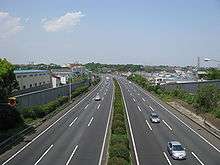
Daisan Keihin Road near Kawasaki
National Route 466 (国道466号) is a national highway in Japan connecting Setagaya, Tokyo and Hodogaya-ku, Yokohama, with a total length of 18.4 km (11.4 mi).
A major part of the road is known as the Daisan Keihin Road (第三京浜道路 Daisan Keihin Dōro), a toll road connecting Tokyo and Yokohama, managed by East Nippon Expressway Company.
List of interchanges and features
| Name | Connections | Dist. from origin (km) |
Notes | Location | |||
|---|---|---|---|---|---|---|---|
| Seta Intersection | Japan National Route 246 | 0.0 | From here to Tamagawa Interchange is commonly known (and signed) as Kanpachi-Dori | Setagaya | Tokyo | ||
| Tamagawa Interchange | Met. Route 311 (Kanjō Hachigō Route) | 1.8 | Setagaya | Tokyo | |||
| Keihin-Kawasaki | 4.0 | Kanagawa | |||||
| Tsuzuki | 9.5 | Kanagawa | |||||
| Kohoku | 12.5 | Tsuzuki-ku, Shin Yokohama | Kanagawa | ||||
| Hodogaya | Shuto Expressway Mitsuzawa Route (K2) Yokohama Shindo |
17.0 | Kanagawa | ||||
| Through to | |||||||
Tolls
In short, the tolls average 50 or 100 yen per exit. The entire toll section is ¥390 for cars.
Coordinates: 35°36′01″N 139°38′00″E / 35.60025°N 139.633285°E
| Wikimedia Commons has media related to Route 466 (Japan). |
This article is issued from Wikipedia - version of the 11/8/2016. The text is available under the Creative Commons Attribution/Share Alike but additional terms may apply for the media files.