Jamu Mare
| Jamu Mare | |
|---|---|
| Commune | |
|
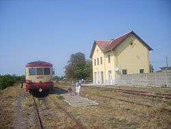
Train station in Jamu Mare | |
 Jamu Mare | |
| Coordinates: 45°15′N 21°25′E / 45.250°N 21.417°E | |
| Country |
|
| County |
|
| Government | |
| • Mayor | Valeriu Filipiac (PSD) |
| Population (2002)[1] | 3,327 |
| Time zone | EET (UTC+2) |
| • Summer (DST) | EEST (UTC+3) |
Jamu Mare is a commune in Timiș County, Banat, Romania.
Name
In Romanian the name means "Greater Jam/Žam". On the other side of the border, in Serbia, there is a village called Mali Žam (Smaller Žam/Jam). Names in other languages: German: Freudenthal or Gross-Scham, Hungarian: Nagyzsám.
Villages and population
The commune is composed of five villages: Clopodia (Klopódia), Ferendia (Ferendia), Gherman (Ermény), Jamu Mare and Lățunaș (Lacunás). The village of Jamu Mare has a population of 1,414, while the whole commune has a population of 3,059 people (as of January 2009).
Transport
Jamu Mare is now a railway terminus, but between 1925 and 1930, trains would pass through it all the way to Vršac in present-day Serbia. Train services to Gătaia and Buziaş are now operated by Regiotrans.
Four county roads run through the commune.
History
The village was first mentioned in a document in 1343, under the name "villa Zamer".
In 1717, the village Scham had 67 houses. At the end of the 18th century, Hungarian statistician Fényes Elek recorded that the village called Nagy Zsám had a population of 1,562, under the rule of the nobleman Ludovic Karácsony.
In 1786 the German colony Freudenthal was founded, at a distance of 4 km away from the current site of the village of Jamu Mare. During the 50 years following 1809, the Romanian population was expelled from the commune, so as to make room for the German families coming from Fibiș, Iecea and Grabaț. In 1893 the German colony was included in the village of Jamu Mare.
From 1919 to 1924 the commune belonged to the Serbo-Croat Kingdom.
Demographics
In 2002, in the commune there were 2,894 Romanians, 240 Hungarians, 63 Germans, 73 Romani people and 54 people from other ethnic groups.
In 2009, the stable population count of the commune was 3095 persons.
Coordinates: 45°15′N 21°25′E / 45.250°N 21.417°E
References
- ↑ Romanian census data, 2002; retrieved on March 1, 2010