Jalgaon
| = Jalgaon जळगाव | |
|---|---|
| City | |
| Nickname(s): Banana City | |
 = Jalgaon | |
| Coordinates: 20°59′53″N 75°34′00″E / 20.997984°N 75.566711°ECoordinates: 20°59′53″N 75°34′00″E / 20.997984°N 75.566711°E | |
| Country | India |
| State | Maharashtra |
| Region | Khandesh |
| District | Jalgaon |
| Government | |
| • Type | Mayor-Council |
| • Body | JMC |
| Area | |
| • Total | 68 km2 (26 sq mi) |
| Population (2011) | |
| • Total | 460,468 |
| • Density | 6,800/km2 (18,000/sq mi) |
| Demonym(s) | Jalgaonkar |
| Language | |
| • Official | Marathi |
| Time zone | IST (UTC+5:30) |
| Telephone code | 00-91-257 |
| Vehicle registration | MH 19 |
| Website |
www |
Jalgaon (![]() pronunciation ) is a city in western India, north of Maharashtra in Jalgaon district and in the agricultural region of Khandesh. Jalgaon has a municipal corporation, and had 460,468 residents at the 2011 census. It is 59 km (37 mi) from the Ajanta Caves. Jalgaon, in a Central Railway zone, can be reached by National Highway 6 and has an airport.
pronunciation ) is a city in western India, north of Maharashtra in Jalgaon district and in the agricultural region of Khandesh. Jalgaon has a municipal corporation, and had 460,468 residents at the 2011 census. It is 59 km (37 mi) from the Ajanta Caves. Jalgaon, in a Central Railway zone, can be reached by National Highway 6 and has an airport.
The city, with industrial areas, schools, hospitals, shopping malls and residential areas, has communications and transport infrastructures. Known as Banana City, it contributes about half of Maharashtra's banana production.[1] The Gandhi Museum, with a large library and other Gandhi-related material, is at Gandhi Teerth in the Jain Hills.
Jalgaon has a varied climate. It is hot and dry in summer, with temperatures reaching 47 °C (117 °F) from late May to mid-June; the record high, in May 2010, was 49.2 °C (120.6 °F). Jalgaon receives about 700 millimetres (28 in) of rainfall during the monsoon. Pratibha Patil, the 12th president of India, Ujwal Nikam and Shashank Shankhapal Muktadir Deshmukh are from Jalgaon.
Geography
| Climate data for Jalgaon (1961-1990) | |||||||||||||
|---|---|---|---|---|---|---|---|---|---|---|---|---|---|
| Month | Jan | Feb | Mar | Apr | May | Jun | Jul | Aug | Sep | Oct | Nov | Dec | Year |
| Average high °C (°F) | 30.5 (86.9) |
33.3 (91.9) |
37.9 (100.2) |
41.7 (107.1) |
42.7 (108.9) |
38.2 (100.8) |
33.1 (91.6) |
31.0 (87.8) |
32.9 (91.2) |
35.0 (95) |
32.7 (90.9) |
30.1 (86.2) |
34.92 (94.88) |
| Average low °C (°F) | 12.1 (53.8) |
14.0 (57.2) |
18.8 (65.8) |
24.3 (75.7) |
27.0 (80.6) |
25.9 (78.6) |
24.2 (75.6) |
23.5 (74.3) |
22.9 (73.2) |
19.4 (66.9) |
15.4 (59.7) |
12.6 (54.7) |
20.01 (68.01) |
| Average precipitation mm (inches) | 3.1 (0.122) |
5.8 (0.228) |
6.0 (0.236) |
2.5 (0.098) |
8.0 (0.315) |
134.2 (5.283) |
210.8 (8.299) |
217.7 (8.571) |
93.9 (3.697) |
35.2 (1.386) |
19.6 (0.772) |
12.4 (0.488) |
749.2 (29.495) |
| Source: Climatological Table | |||||||||||||
| Jalgaon | ||||||||||||||||||||||||||||||||||||||||||||||||||||||||||||
|---|---|---|---|---|---|---|---|---|---|---|---|---|---|---|---|---|---|---|---|---|---|---|---|---|---|---|---|---|---|---|---|---|---|---|---|---|---|---|---|---|---|---|---|---|---|---|---|---|---|---|---|---|---|---|---|---|---|---|---|---|
| Climate chart (explanation) | ||||||||||||||||||||||||||||||||||||||||||||||||||||||||||||
| ||||||||||||||||||||||||||||||||||||||||||||||||||||||||||||
| ||||||||||||||||||||||||||||||||||||||||||||||||||||||||||||
Jalgaon has an average elevation of 209 m (686 ft). The Girna River flows north, west of the city. It is connected by rail with Mumbai, Pune, Nagpur, Delhi, Howrah and Ahmedabad. Jalgaon is on Asian Highway 46-National Highway 6, connecting it with Surat and Dhaka via Kolkata. The Ajanta Caves are about 55 km (34 mi) south of the city, and the Yaval Wildlife Sanctuary is about 32 km (20 mi) north.
Demographics
In the 2011 Indian census,[2] Jalgaon had a population of 460,468. According to the 2001 census, males constituted 52 percent of the population and females 48 percent. Jalgaon has an average literacy rate of 76 percent, higher than the national average of 59.5 percent. Male literacy is 80 percent, and female literacy 71 percent. Thirteen percent of the population is under six years of age.
Business
The district produces more than 16 percent of India's bananas; three percent of world banana production is from Jalgaon. According to Mahabanana, a Maharashtra banana growers' association, 66 percent of Maharashtra's banana land is in Jalgaon.
The city is one of the world's largest pulse (dal) milling centres. It has several jewellery manufacturers, and is in a cotton-producing region. With over 500 pharmacies, chemists and drugstores, Jalgaon has the highest number of pharmacies for a city of its size in India.[3] Jalgaon, one of the largest jewellery markets in Maharashtra, is known as the Golden City.
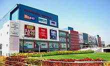
Jalgaon, known as the banana capital of India, is a regional trading hub. The Jalgaon Municipal Corporation, the city's administrative body, occupies a 17-story building. Adjoining it is the Golani complex with more than 500 shops and flats. Across Mahatma Gandhi Road on the way to the Shastri tower is the Phule market, which sells clothing and cosmetics. Another market is the Dana Bazaar. In December 2010 Jalgaon's first shopping mall, the 550,000-square-foot (51,000 m2) Khandesh Central, opened.
Connections
Road
Jalgaon is connected to other cities in Maharashtra and beyond, such as Mumbai, Nashik, Dhule (Dhulia), Nagpur, Durg, Raipur, and Kolkata, with Asian Highway 46 (formerly National Highway 6).
Rail
The Jalgaon station is on the main rail line, and the Karnataka Express, Punjab Mail and the Navjeevan, Jabalpur Garibrath, Gitanjali, Goa and Sachakhand Express stop there. The Bhusawal railway junction, 25 kilometres from Jalgaon, is a major Maharashtra rail junction and connects with New Delhi, Mumbai, Kolkata and Chennai.
Air
Jalgaon Airport, at Kusumba (about six km from the city) has been upgraded by the AAI and was inaugurated on 23 March 2012 by Indian President Pratibha Patil.[4]
Gandhi Teerth

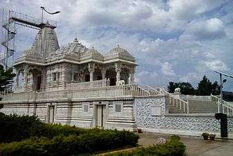
Gandhi Teerth in Jain Hills, a modern museum of Mahatma Gandhi's life and work, has audio guides in English, Hindi and Marathi. The museum has more than 8,000 books written by and about Gandhi, more than 200,000 pages of digitised documents, 152 audio speeches by Gandhi, 85 documentaries and stamps commemorating Gandhi from 116 countries. Its archives have the diaries of Mahadevbhai Desai, Manuben and more than 5,000 issues of weekly publications from India's independence movement.
Education
North Maharashtra University and the international Gandhi Research Foundation are in Jalgaon. President college of hotel management
See also
References
- ↑ "Banana republic Jalgaon bears fruit". Indian Express. 18 June 2004. Retrieved 3 January 2011.
- ↑ "Census of India 2001: Data from the 2001 Census, including cities, villages and towns (Provisional)". Census Commission of India. Archived from the original on 2004-06-16. Retrieved 2008-11-01.
- ↑ Medicine India. "List of Pharmacies, Chemists, Drugstores in Jalgaon".
- ↑ "President inaugurates Jalgaon airport". Newstrackindia.com. 23 March 2012. Retrieved 25 March 2012.
External links
| Topics | |||||||||||||||||||||||
|---|---|---|---|---|---|---|---|---|---|---|---|---|---|---|---|---|---|---|---|---|---|---|---|
| Regions | |||||||||||||||||||||||
| Divisions and Districts |
| ||||||||||||||||||||||
| Million-plus cities in Maharashtra | |||||||||||||||||||||||
| Other cities with municipal corporations | |||||||||||||||||||||||
Portal: Maharashtra | |||||||||||||||||||||||