Jalalabad
| Jalalabad جلال آباد | |||||||||
|---|---|---|---|---|---|---|---|---|---|
From top left to right: A panoramic view of a section of Jalalabad; Jalalabad Bridge; Jalalabad Cricket Stadium; Pashtunistan Square; Mosque in Jalalabad; Governor's House in Jalalabad; Building on a main road. | |||||||||
 Location in Afghanistan | |||||||||
| Coordinates: 34°26′03″N 70°26′52″E / 34.43417°N 70.44778°ECoordinates: 34°26′03″N 70°26′52″E / 34.43417°N 70.44778°E | |||||||||
| Country | Afghanistan | ||||||||
| Province | Nangarhar Province | ||||||||
| Founded | 1570 | ||||||||
| Elevation | 575 m (1,886 ft) | ||||||||
| Population (2014) | |||||||||
| • City | 356,275 | ||||||||
| • Urban | 356,274[1] | ||||||||
| [2] | |||||||||
| Time zone | UTC+4:30 | ||||||||
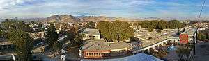


Jalalabad /dʒəˈlæləˌbæd/ (Pashto/Persian: جلال آباد Jalālābād), formerly called Adina Pur (Pashto: آدينه پور) as documented by the 7th century Hsüan-tsang, is a city in eastern Afghanistan. Located at the junction of the Kabul River and Kunar River near the Laghman valley, Jalalabad is the capital of Nangarhar province. It is linked by approximately 155 kilometres (95 mi) of highway with Kabul to the west. Jalalabad is the second-largest city in eastern Afghanistan as well as the centre of its social and business activity because of its border to Pakistan which is the main source of products to all of Afghanistan. Major industries include papermaking, as well as agricultural products including oranges, rice and sugarcane. Jalalabad is one of the leading trading centres with neighbouring Pakistan.[3] The city of Jalalabad has a population of 356,274 (in 2015).[4] it has 6 districts and a total land area of 12,796 Hectares.[5] The total number of dwellings in this city are 39,586.[6]
History
Mauryan Empire
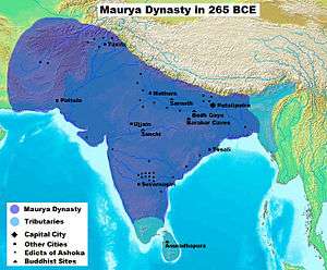
The Jalalabad territory fell to the Maurya Empire (322–185 BCE), which was led by Chandragupta Maurya. The Mauryas introduced Jainism, Hinduism and Buddhism to the region, and were planning to capture more areas of Central Asia until they faced local Greco-Bactrian forces. Seleucus is said to have agreed a peace treaty with Chandragupta by giving control of the territory south of the Hindu Kush to the Mauryas upon intermarriage and receipt of 500 elephants.
Alexander took these away from the Indo-Aryans and established settlements of his own, but Seleucus Nicator gave them to Sandrocottus (Chandragupta), upon terms of intermarriage and of receiving in exchange 500 elephants.[7]— Strabo, 64 BCE–24 CE
Some time after, as he was going to war with the generals of Alexander, a wild elephant of great bulk presented itself before him of its own accord, and, as if tamed down to gentleness, took him on its back, and became his guide in the war, and conspicuous in fields of battle. Sandrocottus, having thus acquired a throne, was in possession of India, when Seleucus was laying the foundations of his future greatness; who, after making a league with him, and settling his affairs in the east, proceeded to join in the war against Antigonus. As soon as the forces, therefore, of all the confederates were united, a battle was fought, in which Antigonus was slain, and his son Demetrius put to flight.[8]
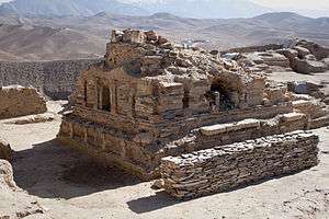
Having consolidated power in the northwest, Chandragupta pushed east towards the Nanda Empire. Afghanistan's significant ancient tangible and intangible Buddhist heritage is recorded through wide-ranging archeological finds, including religious and artistic remnants. Buddhist doctrines are reported to have reached as far as Balkh even during the life of the Buddha (563 BCE to 483 BCE), as recorded by Husang Tsang.
In this context a legend recorded by Husang Tsang refers to the first two lay disciples of Buddha, Trapusa and Bhallika responsible for introducing Buddhism in that country. Originally these two were merchants of the kingdom of Balhika, as the name Bhalluka or Bhallika probably suggests the association of one with that country. They had gone to India for trade and had happened to be at Bodhgaya when the Buddha had just attained enlightenment.[9]
Faxian visited and worshiped the sacred Buddhist sites such as of The Shadow of the Buddha in Nagarhara (modern Jalalabad).[10] In 630 AD Xuan Zang, the famous Chinese Buddhist monk, visited Jalalabad and a number of other locations nearby. The city was a major center of Gandhara's Greco-Buddhist culture in the past until it was conquered by Muslim Arabs in the 7th century. However, not everyone converted to Islam at that period as some still refused to accept it. In Hudud-al-Alam, written in 982 CE, there is reference to a village near Jalalabad where the local king used to have many Hindu, Muslim and Afghan wives.[11]
The region became part of the Afghan Ghaznavid Empire in the 10th century, during the Indian invasions by Sultan Mahmud of Ghazni. Later, it was controlled by the successor Ghurids until the Mongols invaded the area. It then became part of the Timurids.
The modern city gained prominence during the reign of Babur, founder of the Mughal Empire. Babur had chosen the site for this city which was built by his grandson Jalal-uddin Mohammad Akbar in 1570.
The Battle of Jellalabad in 1842 was an Afghan siege of the isolated British outpost at Jellalabad (now Jalalabad) about 130 kilometres (80 mi) east of Kabul. The siege was lifted after five months when a British counterattack routed the Afghans, driving them back to Kabul. The outpost was no more than a wide place in the road with a fort, held by about 2,000 troops under General Sir Robert Sale. After the massacre of the British force during their retreat from Kabul in January 1842, Jellallabad was surrounded by Afghan forces which launched a series of attacks on the force. The British managed to beat off the assaults, and even captured 300 sheep from the besieging force when rations ran short. Eventually, after five months under siege, Sale mounted an attack against the Afghan forces, captured their main camp, baggage, stores, guns, and horses and the Afghans fled to Kabul. The defence of Jellalabad made heroes of the 13th Foot. It is reported that as the regiment marched back through India to return to Britain every garrison fired a ten-gun salute in its honour. Queen Victoria directed that the regiment be made light Infantry, carry the additional title of "Prince Albert's Own" and wear a badge depicting the walls of the town with the word “Jellalabad" visible.
The original name of Jalalabad was Adinapur.[12] It was renamed as Jalalabad in the last decade of the sixteenth century, in honour of the son of Pir Roshan, Jalala, who was fighting the Mughals in the Waziristan area. It remained part of the Mughal Empire until around 1738 when Persian king Nader Shah and his Afsharid forces from Khorasan came to take over control. Nader Shah was accompanied by the young Ahmad Shah Durrani, founder of the modern state of Afghanistan, who would re-conquer the area in 1747 after becoming the new ruler of the Afghans. He used the city while going back and forth during his nine military campaigns into India.
The city was invaded by Ranjit Singh and his Sikh army in the early 19th century, but they were quickly chased out a few days later by Afghan forces of the Durrani Empire. The British forces invaded Jalalabad in 1838, during the First Anglo-Afghan War. In the 1842 Battle of Jellalabad, Akbar Khan besieged the British troops on their way to Jalalabad. In 1878, during the Second Anglo-Afghan War, the British again invaded and set up camps in Jalalabad but withdrew two years later.

Jalalabad is considered one of the most important cities of the Pashtun culture. Seraj-ul-Emarat, the residence of Amir Habibullah and King Amanullah was destroyed in 1929 when Habibullah Kalakani rose to power; the other sanctuaries however, retain vestiges of the past. The mausoleum of both rulers is enclosed by a garden facing Seraj-ul-Emart.
From 1978 to early 1990s, the city served as a strategic location for the pro-Soviet Democratic Republic of Afghanistan. It fell to the Mujahideen in 1992 when they were on their way to capture Kabul. It was conquered by the Taliban in September 1996, becoming part of the Islamic Emirate of Afghanistan. During Operation Enduring Freedom after the September 11 attacks in the United States, the city was invaded and fell to US-backed Afghan forces.
Since late 2001, the military of Afghanistan and the United States armed forces have established a number of bases, with the one at Jalalabad Airport being the largest. The Afghan National Police is in control of security while the International Security Assistance Force (ISAF) also has a heavy presence in and around the city. In early 2011, the U.S. Embassy in Kabul announced that it plans to establish a consulate in Jalalabad.[13] As is the case with other Afghan cities, occasional suicide attacks by militants have taken place in recent years.
Demographics
The city population is estimated to be 356,274 in year 2015.[14] The population of the city is mostly Pashtun people, at 90%. Pashais are 7%. The remaining 3% are Tajiks and Wakhi people. Pashto is the main language of the city and is also used throughout the province. Many people in the city are also fluent in Dari. Although English is very little in use, it is now being taught in most schools.
Nearly all residents of Jalalabad are Muslim, followers of Sunni Islam. The city is home to one of Afghanistan's few Hindu temples, the Darga Hindu Temple on Chowk Omomi Street, founded by Darga Mathara Das in c. 1084 AD.[15]
Land Use
Jalalabad is the Regional Hub in eastern Afghanistan, close to the border with Pakistan. Agriculture is the predominant land use at 44%, higher density of dwellings is found in Districts 1-5 and vacant plots are largely clustered in District 6.[16] Districts 1-6 all have a grid network of roads.[17]
Climate
Jalalabad's climate is hot desert (Köppen: BWh). The city's climate has close resemblance to that of Arizona in the United States.[18] It receives six to eight inches (152 to 203 mm) of rainfall per annum which are limited to winter and the months of spring. Frosts are not common, and during the summer, the mercury can reach a maximum of 120 °F (49 °C).[19]
The north and southwestern parts of the city which has lower elevation are welcoming places to winds from the north and west cooling the parts in summer months. Jalalabad has the highest relative humidity in summer compared to other Afghan cities. However the moderate temperatures of winter has led to various people down the history establishing their settlements in the city.[19]
| Climate data for Jalalabad | |||||||||||||
|---|---|---|---|---|---|---|---|---|---|---|---|---|---|
| Month | Jan | Feb | Mar | Apr | May | Jun | Jul | Aug | Sep | Oct | Nov | Dec | Year |
| Record high °C (°F) | 25.0 (77) |
28.8 (83.8) |
34.5 (94.1) |
40.5 (104.9) |
45.4 (113.7) |
47.5 (117.5) |
44.7 (112.5) |
42.4 (108.3) |
41.2 (106.2) |
38.2 (100.8) |
32.4 (90.3) |
25.4 (77.7) |
47.5 (117.5) |
| Average high °C (°F) | 15.9 (60.6) |
17.9 (64.2) |
22.5 (72.5) |
28.3 (82.9) |
34.7 (94.5) |
40.4 (104.7) |
39.3 (102.7) |
38.0 (100.4) |
35.2 (95.4) |
30.5 (86.9) |
23.3 (73.9) |
17.5 (63.5) |
28.63 (83.52) |
| Daily mean °C (°F) | 8.5 (47.3) |
10.9 (51.6) |
16.3 (61.3) |
21.9 (71.4) |
27.7 (81.9) |
32.7 (90.9) |
32.8 (91) |
31.9 (89.4) |
28.1 (82.6) |
22.2 (72) |
14.9 (58.8) |
9.5 (49.1) |
21.45 (70.61) |
| Average low °C (°F) | 2.9 (37.2) |
5.6 (42.1) |
10.5 (50.9) |
15.3 (59.5) |
19.8 (67.6) |
24.7 (76.5) |
26.7 (80.1) |
26.2 (79.2) |
21.4 (70.5) |
14.4 (57.9) |
6.9 (44.4) |
3.5 (38.3) |
14.83 (58.68) |
| Record low °C (°F) | −14.1 (6.6) |
−9.5 (14.9) |
−1.0 (30.2) |
6.1 (43) |
10.6 (51.1) |
13.5 (56.3) |
19.0 (66.2) |
17.5 (63.5) |
11.0 (51.8) |
2.7 (36.9) |
−4.5 (23.9) |
−5.5 (22.1) |
−14.1 (6.6) |
| Average precipitation mm (inches) | 18.1 (0.713) |
24.3 (0.957) |
39.2 (1.543) |
36.4 (1.433) |
16.0 (0.63) |
1.4 (0.055) |
6.9 (0.272) |
7.7 (0.303) |
8.3 (0.327) |
3.2 (0.126) |
8.3 (0.327) |
12.1 (0.476) |
181.9 (7.162) |
| Average rainy days | 4 | 5 | 8 | 8 | 4 | 1 | 1 | 1 | 1 | 1 | 2 | 3 | 39 |
| Average relative humidity (%) | 61 | 60 | 62 | 59 | 47 | 40 | 52 | 58 | 56 | 55 | 58 | 63 | 55.9 |
| Mean monthly sunshine hours | 180.9 | 182.7 | 207.1 | 227.8 | 304.8 | 339.6 | 325.9 | 299.7 | 293.6 | 277.6 | 231.0 | 185.6 | 3,056.3 |
| Source: NOAA (1964-1983) [20] | |||||||||||||
Flora and Fauna
Jalalabad is home to a large number of fruits. Various types of citrus fruits like orange, tangerine, grapefruit, lemon, lime grow in gardens as well as in orchards.[19] The orange trees yield a crop only once in three years. The narindj variety of orange is the most common one which has yellow skin and its taste is a combination of orange and grapefruit. The grapefruits grown here have a diameter of eight or nine inches. Per year 1800 tonnes of pomegranates, 334 tones of grapes, and 7750 tones of mulberries are produced in Jalalabad.[21] The fruits are either sold in local markets or transported to Kabul markets from where they are exported. The second most common crop is local vatani variety of sugarcane. It contains 15% sugar by weight.[22]
Transportation
The Jalalabad Airport was built for dual-use, civilian and military. It is designed to serve the population of Nangarhar Province and neighboring province for domestic flights. The airport is currently used by NATO-led forces, including the Afghan Air Force, and houses large number of ISAF forces. The airport is also used as one of the launching and monitoring spots of drone attacks in Pakistan.
There are proposals for the establishment of Afghanistan's rail network linking Jalalabad with Pakistan Railways, allowing for increased trade of goods, people and commerce between the two countries.[23]
Jalalabad is connected by main roads with the Afghan capital of Kabul, the city of Peshawar in Khyber Pakhtunkhwa, Pakistan, and several nearby Afghan cities and towns. All trade between Afghanistan and Pakistan passes through this city. The highway between Jalalabad and Kabul was resurfaced in 2006, reducing the transit time between these two important cities. This highway is considered to be one of the most dangerous in the world because of the large number of accidents.[24] An improvement in the road networks between Jalalabad and Peshawar has also been proposed, with the intention of widening the existing road and improving security to attract more tourists and allow for safer passage of goods between to the two countries.
Places of interest


Jalalabad is considered one of the most beautiful cities of Afghanistan. It has plenty of greenery and water. About 15 kilometers from Jalalabad, a new city called Ghazi Amanullah Khan Town is under development. Named after King Amanullah Khan, it is said to be the first, the biggest and the most modern city in the history of Afghanistan.[25]
Jalalabad is considered the capital of Afghan cricket, with many of the national players coming from the surrounding areas. Construction has begun near the city on one of Afghanistan's cricket stadiums. It is hoped that this ground will serve the domestic competition and attract international teams.
- Airports
Jalalabad Airport (IATA: JAA, ICAO: OAJL) is located 5 kilometres (3 mi) southeast of Jalalabad city in Afghanistan. This airport is currently being used only for military purposes and sometimes the United Nations' aircraft use this airport. It is occupied and maintained by the United States Armed Forces. They operate out of Forward Operating Base Fenty, which is adjacent to Jalalabad Airport. The Afghan Air Force (AAF) and members of the International Security Assistance Force also use the airport.
- New Jalalabad Airport
Hamidullah Qaderi, Minister of Transport and Civil Aviation of Afghanistan, announced in April 2009 the construction of a new civilian airport in the Gambiri area northwest of Jalalabad. The new airport will be constructed with financial assistance from the United States.
- Foreign consulates
India and Pakistan operate their consulate here for trade, military and political links.
- Stadiums
- Sherzai Cricket Stadium (under construction)
- National Football Stadium
The province is represented in domestic cricket competitions by the Nangarhar province cricket team. National team member Hamid Hasan was born in the province and he currently represents Afghanistan in international cricket. The Ghazi Amanullah Khan International Cricket Stadium is the first international standard cricket stadium in Afghanistan. It is located in the Ghazi Amanullah Khan Township, about 15 kilometres south-east of Jalalabad in Nangarhar Province.[1] Construction on the stadium began in March 2010 when the foundation stone was laid by Minister of Finance and president of the Afghanistan Cricket Board, Omar Zakhilwal.[2] The project, which was developed on 30 acres of land donated by the developer constructing the Ghazi Amanullah Khan Township,[3] cost up the first phase of construction $1.8 million. The first phase, which took one year to complete, included the completion of the stadium itself.[2] The remainder of the phases will see the construction of a pavilion, accommodation for players and administrative buildings.[2] The stadium, which has a capacity of 14,000, was completed before the national team and under-19 team left for Canada and the Under-19 Cricket World Cup Qualifier in Ireland respectively. The two sides inaugurated the stadium in a Twenty20 match.[2] It is hoped that the stadium will be able to attract international teams to play Afghanistan, who currently have One Day International status until at least 2013.
- Mausoleums
- Mausoleum of King Amanullah Khan
- Mausoleum of Khan Abdul Ghaffar Khan
- Mausoleum of Mohammad Gul Khan Momand
- Mosques
- Hospitals
Jalalabad district has three big hospitals: Fatumatu Zahra, Medical Hospital of Nangarhar, and the General Hospital of Public Health. The General Hospital of Public Health is one of the largest in the country.[8] As of July 24, 2004, polio (NSL3) has been identified and reported in the Jalalabad district area. This specific case has been linked to others reported in the past due to the highly transient and mobile population.[9]
- Universities
Nangarhar University (Pashto: د ننګرهار پوهنتون) is a government-funded higher learning institution in Jalalabad, Afghanistan. It is the second largest university in Afghanistan.[2] It has approximately 25 faculty and 3,500 students.[3] Nangarhar University was established in 1962 as a medical college.[4] It was later merged with other local colleges to become a full-fledged university. It now houses faculties in agriculture, engineering, education, medicine, theology, pedagogy, political science and veterinary medicine.
Nangarhar consists of many faculties including engineering, political science, economics, teachers' training, veterinary, and computer science. Nangarhar Medical Faculty (NMF) is the second largest medical school in Afghanistan. They also take part in an e-learning program organized by Afghans Next Generation e-Learning.
The nearest village within walking distance of Jalalabad is Ghouchak.
Sister cities
See also
- Battle of Jellalabad
- Gul Agha Sherzai
- Jalalabad Airport
- Fazal Haq Mujahid
- Provincial Reconstruction Team
- International Security Assistance Force
References
- ↑ "The State of Afghan Cities report 2015".
- ↑ http://www.mrrd.gov.af/nabdp/Provincial%20Profiles/Nangarhar%20PDP%20Provincial%20profile.pdf
- ↑ "Jalālābād". Encyclopædia Britannica. Retrieved 2011-08-15.
- ↑ "The State of Afghan Cities report2015".
- ↑ "The State of Afghan Cities report 2015".
- ↑ "The State of Afghan Cities report2015".
- ↑ Nancy Hatch Dupree / Aḥmad ʻAlī Kuhzād (1972). "An Historical Guide to Kabul - The Name". American International School of Kabul. Retrieved 2010-09-18.
- ↑ Historiarum Philippicarum libri XLIV, XV.4.19
- ↑ Puri, Baij Nath (1987). Buddhism in central Asia. Motilal Banarsidass Publ. p. 352. ISBN 81-208-0372-8. Retrieved 2010-11-03.
- ↑ Kuwayama, Shoshin. "The Hephthalites in Tokharistan and Northwest India". In Liu, Xinru. India and Central Asia. Permanent Black. p. 240. ISBN 8178243474.
- ↑ Vogelsang, Willem (2002). The Afghans. Wiley-Blackwell. p. 18. ISBN 978-0-631-19841-3.
- ↑ Gazetteer of the Peshawar District 1897-98 Page 55
- ↑ Naadem, Bashir Ahmad (February 24, 2011). "US to open consulates in more provinces". Pajhwok Afghan News. Retrieved 2011-08-15.
- ↑ "The State of Afghan Cities report 2015".
- ↑ Singh, Pritpal (1 May 2013). "Mission Afghanistan".
- ↑ "The State of Afghan Cities report 2015".
- ↑ "The State of Afghan Cities report 2015".
- ↑ Michel, p.29
- 1 2 3 Michel, p.30
- ↑ "Jalal Abad Climate Normals 1964-1983". National Oceanic and Atmospheric Administration. Retrieved December 25, 2012.
- ↑ Michel, p.32
- ↑ Michel, p.33
- ↑ "Work on Jalalabad railways station launched". Pajhwok Afghan News. 3 January 2013. Retrieved 2013-01-04.
- ↑ "On Afghan Road, Scenes of Beauty and Death"
- ↑ "Ghazi Amanullah Khan City". najeebzarab.af. 2009. Retrieved 2011-08-15.
Notes
- Aloys Arthur Michel. The Kabul, Kunduz, and Helmand Valleys and the National Economy of Afghanistan: A Study of Regional Resources and the Comparative Advantages of Development. National Academies.
Further reading
- Published in the 19th century
- Edward Balfour (1885), "Jalalabad", Cyclopaedia of India (3rd ed.), London: B. Quaritch
- Published in the 20th century
- "Jalalabad", The Encyclopaedia Britannica (11th ed.), New York: Encyclopaedia Britannica, 1910, OCLC 14782424
- Published in the 21st century
- Grove Encyclopedia of Islamic Art & Architecture. Oxford University Press. 2009.
External links
| Wikimedia Commons has media related to Jalalabad. |
- Ghazi Amanullah Khan City on YouTube
- The Silk Road Journey With Xuanzang By Sally Hovey Wriggins
- "Jalalabad". Islamic Cultural Heritage Database. Istanbul: Organization of Islamic Cooperation, Research Centre for Islamic History, Art and Culture.