Jakar
| Jakar Chakkar Byakar | |
|---|---|
|
| |
 Jakar Location in Bhutan | |
| Coordinates: 27°33′0″N 90°44′0″E / 27.55000°N 90.73333°E | |
| Country |
|
| Dzongkhag | Bumthang District |
| Settled | ca. 1549 |
| Climate | Cwb |

Jakar (Dzongkha: བྱ་ཀར་; Wylie: Bya-kar) is a town in the central-eastern region of Bhutan. It is the district capital (dzongkhag thromde)[1] of Bumthang District and the location of Jakar Dzong, the regional dzong fortress. The name Jakar roughly translates as "white bird" in reference to its foundation myth, according to which a roosting white bird signaled the proper and auspicious location to found a monastery around 1549.[2]:168
Geography
Jakar is located in Bumthang (Choekhor) Valley within Chhoekhor Gewog in central Bumthang.[2] Administratively, however, Jakar is a separate thromde (municipality) inside the gewog. The administrative office for the Choekhor Gewog is located in the northern suburbs of Jakar.[1][3] Just north of Jakar lies Wangchuck Centennial Park, a protected area of Bhutan.[4]
Climate
Jakar has a subtropical highland climate (Köppen: Cwb).
| Climate data for Jakar | |||||||||||||
|---|---|---|---|---|---|---|---|---|---|---|---|---|---|
| Month | Jan | Feb | Mar | Apr | May | Jun | Jul | Aug | Sep | Oct | Nov | Dec | Year |
| Daily mean °C (°F) | 3.7 (38.7) |
5.7 (42.3) |
8.9 (48) |
12.2 (54) |
15.0 (59) |
17.4 (63.3) |
17.9 (64.2) |
17.5 (63.5) |
16.4 (61.5) |
12.7 (54.9) |
8.0 (46.4) |
4.9 (40.8) |
11.7 (53.1) |
| Average precipitation mm (inches) | 6 (0.24) |
11 (0.43) |
37 (1.46) |
69 (2.72) |
157 (6.18) |
294 (11.57) |
317 (12.48) |
252 (9.92) |
181 (7.13) |
66 (2.6) |
11 (0.43) |
3 (0.12) |
1,404 (55.28) |
| Source: Climate-Data.org[5] | |||||||||||||
Schools
There are 19 schools in the dzongkhag. There are two higher secondary schools, three middle secondary schools and two lower secondary schools and the rest are community schools.
Transport
Jakar is accessed via a north-south road that connects to the Lateral Road, the main highway of Bhutan.[3]
Jakar is also the site of Bathpalathang Airport. The airport formed part of the Royal Bhutanese Government's 10th Five Year Plan (2008). The airport was originally scheduled to open in October 2010,[6] but faced many delays due to soil stability,[7][8] river diversion,[9][10] funding,[11] and labour.[12][13][14][15] Labour and material shortages through early 2011 prompted a new target date of July 2011, however as of September 2011, the airport had not been opened for operations.[12][16] Further complications have arisen from legislated land and property compensation schemes for those who have been forced to move to accommodate the airport.[17] Both Drukair and Tashi Air conducted inaugural flights to Bathpalathang on 17 December 2011—coinciding with the national day of Bhutan.[18][19] The first commercial Drukair flight between Paro and Bathpalathang occurred on 23 December 2011; it failed to make a profit.[20]
History
The town is the site of Chakhar Lhakhang, a small and unassuming temple which marks the site of the "Iron Palace" of Sindhu Raja, the Indian monarch who is believed to have first invited Guru Rinpoche to Bhutan in 746.[21][22][23]:34–5 The current building is said to have been constructed by Terton Dorje Lingpa in the 14th century.
According to the Jakar foundation myth, a roosting white bird signaled the proper and auspicious location to found a monastery around 1549. The settlement thus earned the moniker Jakar, meaning "white bird."[2]:168
There are many significant Buddhist sacred sites nearby the town, such as Kurjey Lhakhang, which holds a body print of Guru Rinpoche; Jambey Lhakhang, one of the 108 monasteries that in mythology were miraculously constructed by King Songten Gampo in one night; and Tamsshing Lhakhag established by Terton Padma Lingpa (1450–1521).[24] In addition, one of the country's largest monastic colleges, Lhodrak Kharchhu Monastery, overlooks Jakar.
Jakar Dzong
Constructed in 1667, Jakar Dzong sits atop a ridge above the town of Jakar. The dzong fortress is now an administrative center. It may be the largest dzong in Bhutan, with a circumference of more than 1,500 metres (4,900 ft).[2]:168
Tourism
Being located in the spacious and tree covered Bumthang (Choekhor) Valley, the area is also a popular tourist destination, and consequently the town is served by several good quality hotels and craft shops. there are so many guest houses.
The bazaar is located on a street of single story buildings in an area of the town called Chamkhar. A new bazaar consisting of three story traditional buildings in the Dekiling area was planned to be completed in 2010.
Culture
Jakar, like the rest of Bumthang District and its neighbors, is culturally part of eastern Bhutan. While Dzongkha is the national language of administration and instruction, local languages include Bumthang and Brokkat. Jakar is famous throughout Bhutan for its distinctive and brightly colored woven wool items called yethra.
Gallery
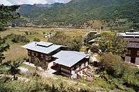 Houses near Jakar
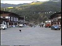 Jakar street
See also
References
- 1 2 Pelden, Sonam (2010-05-07). "Cabinet Approves Thromdes". Bhutan Observer online. Retrieved 2011-07-30.
- 1 2 3 4 Brown, Lindsay; Mayhew, Bradley; Armington, Stan; Whitecross, Richard W. (2007). Bhutan. Lonely Planet Country Guides (3 ed.). Lonely Planet. ISBN 1740595297. Retrieved 2011-08-09.
- 1 2 "Chiwogs in Bumthang" (PDF). Election Commission, Government of Bhutan. 2011. Retrieved 2011-07-28.
- ↑ "Parks of Bhutan". Bhutan Trust Fund for Environmental Conservation online. Bhutan Trust Fund. Retrieved 2011-03-26.
- ↑ "Climate: Jakar". Climate-Data.org. Retrieved 16 April 2014.
- ↑ Wangchuk, Samten (2010-06-01). "Who'll Take Wing". Kuensel online. Retrieved 2011-09-08.
- ↑ "Bathpalathang Airport Will not Complete on Time". Bhutan Broadcasting Service. 2010-08-14. Retrieved 2011-09-08.
- ↑ Yeshi, Samten (2010-08-18). "Quality Outweighs Deadline". Kuensel online. Retrieved 2011-09-08.
- ↑ Saraswati (2010-12-10). "Despite River Training Works, Bathpalathang Airport Will Finish on Time". Business Bhutan online. Retrieved 2011-09-08.
- ↑ Yeshi, Samten (2010-06-02). "River Diversion Work Begins". Kuensel online. Retrieved 2011-09-08.
- ↑ Dema, Kesang (2010-09-21). "Penalty Paid ... From One Pocket to Another". Kuensel online. Retrieved 2011-09-08.
- 1 2 Yeshi, Samten (2011-05-20). "Second Deadline Likely to be Missed". Kuensel online. Retrieved 2011-09-08.
- ↑ Dorji, Gyalsten K (2009-11-26). "2 Domestic Airports by 2010". Kuensel online. Retrieved 2011-07-25.
- ↑ Pelden, Sonam (2010-01-08). "Groundwork Begins for Taking to the Air". Kuensel online. Retrieved 2011-07-25.
- ↑ Dorji, Gyaltsen K (2011-02-09). "An April Beginning?". Kuensel online. Retrieved 2011-08-09.
- ↑ Tenzin, Tashi (2011-09-08). "Picture Story – So Close Yet So Far". Kuensel online. Retrieved 2011-09-08.
- ↑ Yeshi, Samten (2011-02-01). "Unresolved Land Issues in Bumthang". Kuensel online. Retrieved 2011-09-08.
- ↑ Dorji, Gyalsten K (2011-12-19). "On Drukair's Historic Flight". Kuensel online. Retrieved 2012-01-16.
- ↑ "Aerial photo". 2011-12-29. Retrieved 2012-02-23.
- ↑ Dorji, Gyalsten K (2011-12-23). "Drukair's Maiden Flight Fails to Break Even". Kuensel online. Retrieved 2012-01-16.
- ↑ Hattaway, Paul (2004). Peoples of the Buddhist World: a Christian Prayer Diary. William Carey Library. p. 30. ISBN 0878083618. Retrieved 2011-08-20.
- ↑
 This article incorporates public domain material from the Library of Congress document: Worden, Robert L. (September 1991). Savada, Andrea Matles, ed. "Bhutan: A country study". Federal Research Division. Arrival of Buddhism.
 - ↑ Dorji, C. T. (1994). History of Bhutan based on Buddhism. Sangay Xam, Prominent Publishers. ISBN 8186239014. Retrieved 2011-08-12.
- ↑ Padel, Ruth (2006). Tigers in red weather: a quest for the last wild tigers. Bloomsbury Publishing USA. pp. 139–40. ISBN 0802715443. Retrieved 2011-08-21.
External links
 Jakar travel guide from Wikivoyage
Coordinates: 27°33′N 90°44′E / 27.550°N 90.733°E