Jacob's Well (Texas)
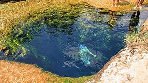
Jacob's Well is a perennial karstic spring in the Texas Hill Country flowing from the bed of Cypress Creek, located northwest of Wimberley, Texas.[1][2] The 12-foot (3.7 m) diameter mouth of the spring serves as a popular swimming spot for the local land owners whose properties adjoin Cypress Creek. From the opening in the creek bed, Jacob's Well cave descends vertically for about 30 feet (9.1 m), then continues downward at an angle through a series of silted chambers separated by narrow restrictions, finally reaching an average depth of 120 feet (37 m). Until the modern era, the Trinity Aquifer-fed natural artesian spring gushed water from the mouth of the cave, with a measured flow in 1924 of 170 US gallons per second (640 L/s), discharging 6 feet (1.8 m) into the air.[3][4]
Due to development in the area, the level of the Trinity Aquifer has dropped affecting the flow of water through Jacob's Well. In the modern era, what remains visible of the spring is a faint ripple on the surface of Cypress Creek. The spring ceased flowing for the first time in recorded history in 2000, again ceasing to flow in 2008.[5] This resulted in now ongoing measures to address local water conservation and quality. Hays County purchased 50 acres (20 ha) of land around Jacob's Well in 2010, in an attempt to protect the spring from development. An additional thirty-one acres was transferred to the county from the neighboring Jacob’s Well Natural Area (administered by the Wimberley Valley Watershed Association (WVWA)), the new, eighty-acre (32 hectares) named the Westridge Tract.[6][7]
The system has been explored and mapped by cave divers of the Jacob's Well Exploration Project and has been shown to consist of two principal conduits. One passageway measures approximately 4,500 feet (1,400 m) from the surface and a secondary one extends approximately 1,000 feet (300 m) in length from the point where it diverges from the main conduit.[8] The cave is also an attraction for open-water divers, some of whom are inexperienced with the specialized techniques and equipment used in cave diving, which has resulted in eight fatalities at this site between 1964 and 1984 (seven men and one woman).[9][10][11][12]
References
- ↑ Dedden, John Eric. "The Hydrology and Biology of Cypress Creek (Hays County), a Subtropical Karstic Stream in South Central Texas." Texas State University-San Marcos. http://ecommons.txstate.edu/bioltad/14/
- ↑ "Horseback Magazine Online." "Iconic Jacob’s Well Saved From Development in Texas." December 21, 2010. http://horsebackmagazine.com/hb/archives/5481
- ↑ Dedden, John Eric. "The Hydrology and Biology of Cypress Creek (Hays County), a Subtropical Karstic Stream in South Central Texas." Texas State University-San Marcos. http://ecommons.txstate.edu/bioltad/14/
- ↑ "Bond, Louie. "The Fatal Allure of JACOB'S WELL." 2001. http://www.visitwimberley.com/jacobswell/index.shtml
- ↑ "Jacob's Well Stops Flowing."http://www.texaswatermatters.org/pdfs/news_542.pdf
- ↑ Price, Asher. "50 acres added to Jacob's Well." "Austin American Statesman." December 20, 2010. http://www.statesman.com/news/local/50-acres-added-to-jacobs-well-1136793.html
- ↑ "Horseback Magazine Online." "Iconic Jacob’s Well Saved From Development in Texas." December 21, 2010. http://horsebackmagazine.com/hb/archives/5481
- ↑ "The Well". Jacob's Well Exploration Project. Retrieved 11 February 2016.
- ↑ Express and News. San Antonio, Texas. Page 1. 19 July, 1964.
- ↑ Harrigan, Stephan. Down in the Depths. Texas Monthly. Vol. 8. Pages 97-99 and 162-166 (1980).
- ↑ Paris News. Paris, Texas. Page 5. 25 Nov., 1983.
- ↑ Tipps, Jonhy. Come Dive in Jacob's Well with Me. The Texas Caver. Vol. 29. Pages 23-31 (1984). https://web.archive.org/web/20160821190456/http://www.karstportal.org/FileStorage/Texas_Caver/1984-v29-n02.pdf
Coordinates: 30°2′4″N 98°7′34″W / 30.03444°N 98.12611°W
External links
| Wikimedia Commons has media related to Jacob's Well (Texas). |
- Jacob's Well Exploration Project
- Jacob's Well Natural Area
- Hill Country Outdoor Guide: Jacob's Well Natural Area
- The Hydrology and Biology of Cypress Creek (Hays County), a Subtropical Karstic Stream in South Central Texas
- Austin American Statesman: 50 acres added to Jacob's Well
- Horseback Magazine Online: Iconic Jacob’s Well Saved From Development in Texas
- Texas Tribune: Texas Debates Who Owns Its Water
- Texas Observer: The End of the Hill Country
- Alternet: Behind Texas's Looming Crisis: Groundwater Scarcity
- Texas Living Waters Project: Jacob's Well Stops Flowing (PDF)
- The Fatal Allure of JACOB'S WELL