Jack's Reef, New York
| Jack's Reef, New York | |
|---|---|
| hamlet | |
 Jack's Reef, New York Location within the state of New York | |
| Coordinates: 43°6′23″N 76°25′56″W / 43.10639°N 76.43222°WCoordinates: 43°6′23″N 76°25′56″W / 43.10639°N 76.43222°W | |
| Country | United States |
| State | New York |
| County | Onondaga |
| Time zone | Eastern (EST) (UTC-5) |
| • Summer (DST) | EDT (UTC-4) |
| ZIP codes | 13112 |
| Area code(s) | 315 |
Jack's Reef is a hamlet in the Town of Van Buren, New York in Onondaga County, New York. It was developed around an inn where Old Route 31 (supplanted by modern NY Route 31) bent around a large oxbow in the Seneca River. Subsequently a canal was cut about a mile to the north, which shortened the navigation route. Consequently, Jack's Reef lost virtually all commercial and much recreational traffic. The nearby Seneca River still attracted summer residents, however. Today year-round homes are being built nearby, as the hamlet is within commuting range of Syracuse, New York.
See also
References
Municipalities and communities of Onondaga County, New York, United States | ||
|---|---|---|
| City | 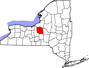 | |
| Towns | ||
| Villages | ||
| CDPs | ||
| Other hamlets |
| |
| Indian reservation | ||
| Footnotes | ‡This populated place also has portions in an adjacent county or counties | |
This article is issued from Wikipedia - version of the 7/2/2016. The text is available under the Creative Commons Attribution/Share Alike but additional terms may apply for the media files.