Ives Trail
| Ives Trail & Greenway | |
|---|---|
|
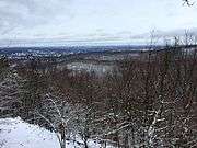
Original entrance to Ives Trail Danbury, Connecticut. | |
| Length | 20 mi (32 km) |
| Location | Ridgefield, Danbury, Bethel and Redding Connecticut |
| Trailheads | Bennett's Pond State Park 41°19′44″N 73°28′51″W / 41.32886°N 73.48086°W; Opposite West Redding Post Office, 268 Simpaug Turnpike, Redding, CT 06896 CT (This is the nearest parking. The trail itself begins inconspicuously about 1/4 mile down Sidecut Road on left hand side.) |
| Use | hiking |
| Hiking details | |
| Trail difficulty | easy, with some difficult sections (bypass routes available) |
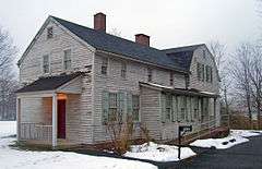
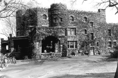
| Sights | Tarrywile Park, Hearthstone Castle |
| Hazards | deer ticks, poison ivy |

The Ives Trail and Greenway is a 20-mile (32 km) hiking trail in the Housatonic Valley Region (also known as Greater Danbury). Its route connects Ridgefield, Danbury, Bethel and Redding. The Ives Trail is named after Charles Ives, a Danbury-born American modernist composer.
The Ives Trail is maintained largely through the efforts of the Ives Trail and Regional Greenway Association.
Trail description
The Ives Trail is primarily used for hiking, backpacking and picnicking.
The trail passes through both public and private lands. Sections of the trail may be used by bicycles and horses. Motorized vehicles are not allowed on any section of the trail. The trail goes over several significant steep areas and is rugged in places. Parts of it are not suitable for casual hikers.
Trail route
The trail goes from Bennett's Pond in Ridgefield to the Hemlock Hills open space into the western section of Wooster Mountain State Park, crosses Rt 7 at a crosswalk, enters the eastern section of Wooster Mountain State Park, goes through an easement area and into Tarrywile Park.
From Tarrywile Park it goes through several easement areas and emerges onto Long Ridge Road. From Long Ridge Road it enters another easement area and eventually into the Terre Haute property of Bethel and Redding Open Space.
The easement areas do not permit bikes.
Trail communities
The Housatonic Range Trail is entirely contained in New Milford, Connecticut. The south end is in the Candlewood Mountain (and Lake) area. The northern end is in the Gaylordsville area.
History and folklore
The Ives Trail was conceived by Danbury City Planner Dennis Elpern.
Origin and name
Historic sites
Hiking the trail

See also
References
External links
Specific Links for this trail:
Further reading
- Books – Connecticut Hiking
- Colson, Ann T. (2005). Connecticut Walk Book East (19 ed.). Rockfall, Connecticut: Connecticut Forest and Park Association. pp. 1–261. ISBN 0961905255.
- Colson, Ann T. (2006). Connecticut Walk Book West (19 ed.). Rockfall, Connecticut: Connecticut Forest and Park Association. pp. 1–353. ISBN 0961905263.
- Emblidge, David (1998). Hikes in southern New England: Connecticut, Massachusetts, Vermont (1 ed.). Mechanicsburg, Pennsylvania: Stackpole Books. pp. 1–304. ISBN 0-8117-2669-X.
- Keyarts, Eugene (2002). Pietrzyk, Cindi Dale, ed. Short Nature Walks: Connecticut Guide Book (7 ed.). Guilford, Connecticut: Falcon Publishing. pp. 1–192. ISBN 0-7627-2310-6.
- Laubach, Rene; Smith, Charles W. G. (2007). AMC's Best Day Hikes in Connecticut (1 ed.). Guilford, Connecticut: Appalachian Mountain Club Books. pp. 1–320. ISBN 1-934028-10-X.
- Ostertag, Rhonda; Ostertag, George (2002). Hiking Southern New England (2 ed.). Guilford, Connecticut: Falcon Publishing. pp. 1–336. ISBN 0-7627-2246-0.
- Books – Connecticut History and Geography
- De Forest, John (1853). History of the Indians of Connecticut from the earliest known period to 1850. Hartford, Connecticut: Wm. Jas. Hamersley. pp. 1–509.
- Hayward, John (1857). New England Gazetteer: Containing Descriptions of the States, Counties, Cities and Towns of New England (2 ed.). Boston, Massachusetts: Otis Clapp. pp. 1–704.
- Trumbull, Benjamin (1797). A Complete History of Connecticut - Civil and Ecclesiastical. Volume I (1818 printing ed.). New Haven, Connecticut: Maltby, Goldsmith & Co. and Samuel Wadsworth. pp. 1–1166.
- Trumbull, Benjamin (1797). A Complete History of Connecticut - Civil and Ecclesiastical. Volume II (1818 printing ed.). New Haven, Connecticut: Maltby, Goldsmith & Co. and Samuel Wadsworth. pp. 1–1166.
| ||