Islip, New York
| Islip, New York | |
|---|---|
| Town | |
| Town of Islip | |
|
Islip Town Hall, the heart of both the Town and Hamlet of Islip | |
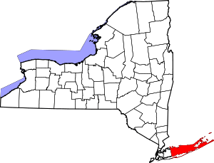
 Map highlighting the Town of Islip | |
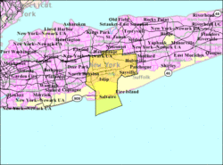
 Islip, New York Location within the state of New York | |
| Coordinates: 40°45′24″N 73°11′56″W / 40.75667°N 73.19889°WCoordinates: 40°45′24″N 73°11′56″W / 40.75667°N 73.19889°W | |
| Country | United States |
| State | New York |
| County | Suffolk |
| Government | |
| • Type | Civil Township |
| • Supervisor | Angie M. Carpenter (R)[1] |
| Area | |
| • Total | 163.1 sq mi (422.5 km2) |
| • Land | 105.3 sq mi (272.7 km2) |
| • Water | 57.8 sq mi (149.8 km2) |
| Elevation | 7 ft (2 m) |
| Population (2010)[2] | |
| • Total | 335,543 |
| • Density | 2,100/sq mi (790/km2) |
| Time zone | Eastern (EST) (UTC-5) |
| • Summer (DST) | EDT (UTC-4) |
| ZIP code | 11705, 11706, 11716, 11717, 11718, 11722, 11730, 11739, 11749, 11751, 11752, 11760, 11769, 11770, 11782, 11795, 11796, 11702 (part), 11729 (part), 11742 (part) , 11741 (part) |
| Area code(s) | 631 |
| FIPS code | 36-38000 |
| GNIS feature ID | 0979097 |
| Website |
www |

Islip (/ˈaɪslɪp/ EYE-slip) is one of ten towns in Suffolk County, New York (USA). Located on the South Shore of Long Island, the town population was 335,543 at the 2010 census.[2] Within the Town of Islip is a smaller, unincorporated hamlet and census-designated place also named Islip.
Demographics
| Historical population | |||
|---|---|---|---|
| Census | Pop. | %± | |
| 1790 | 609 | — | |
| 1800 | 958 | 57.3% | |
| 1810 | 885 | −7.6% | |
| 1820 | 1,156 | 30.6% | |
| 1830 | 1,653 | 43.0% | |
| 1840 | 1,909 | 15.5% | |
| 1850 | 2,602 | 36.3% | |
| 1860 | 3,845 | 47.8% | |
| 1870 | 4,597 | 19.6% | |
| 1880 | 6,453 | 40.4% | |
| 1890 | 8,783 | 36.1% | |
| 1900 | 12,545 | 42.8% | |
| 1910 | 18,346 | 46.2% | |
| 1920 | 20,709 | 12.9% | |
| 1930 | 33,194 | 60.3% | |
| 1940 | 51,182 | 54.2% | |
| 1950 | 71,465 | 39.6% | |
| 1960 | 172,959 | 142.0% | |
| 1970 | 278,880 | 61.2% | |
| 1980 | 298,897 | 7.2% | |
| 1990 | 299,587 | 0.2% | |
| 2000 | 322,612 | 7.7% | |
| 2010 | 335,543 | 4.0% | |
| Est. 2014 | 336,793 | [3] | 0.4% |
At the 2000 census,[5] there were 322,612 people, 98,936 households and 78,555 families residing in the town. The population density was 3,064.5 per square mile (1,183.1/km²). There were 104,278 housing units at an average density of 990.5 per square mile (382.4/km²). The racial makeup of the town was 77.25% White, 9.02% Black or African American, 0.26% Native American, 2.17% Asian, 0.05% Pacific Islander, 8.32% from other races, and 2.93% from two or more races. Hispanic or Latino of any race were 20.16% of the population.
There were 98,936 households of which 39.4% had children under the age of 18 living with them, 62.4% were married couples living together, 12.3% had a female householder with no husband present, and 20.6% were non-families. 16.2% of all households were made up of individuals and 6.4% had someone living alone who was 65 years of age or older. The average household size was 3.22 and the average family size was 3.55.
27.4% of the population were under the age of 18, 8.1% from 18 to 24, 32.4% from 25 to 44, 22.2% from 45 to 64, and 9.9% who were 65 years of age or older. The median age was 35 years. For every 100 females there were 96.7 males. For every 100 females age 18 and over, there were 93.1 males.
According to a 2006 estimate, the median household income was $78,991, and the median family income was $86,190.[6] Males had a median income of $49,069 versus $33,660 for females. The per capita income for the town was $29,699. About 4.1% of families and 6.2% of the population were below the poverty line, including 7.9% of those under age 18 and 7.0% of those age 65 or over.
Geography and climate
Geography
According to the United States Census Bureau, the town has a total area of 163.1 square miles (422.5 km²), of which, 105.3 square miles (272.7 km²) is land and 57.8 square miles (149.8 km²) (35.46%) is water.
The Town of Islip has the following boundaries: to the west, the Town of Babylon (at approximately route 231); to the east, the Town of Brookhaven (at approximately Nicoll's Road); to the north, the Town of Smithtown (at approximately the Long Island Expressway); and to the south, the Atlantic Ocean. The town includes part of Fire Island and the Great South Bay.
Climate
Under the Köppen climate classification, Islip straddles the humid subtropical (Cfa) and a humid continental (Dfa), with some maritime influence; it is part of USDA hardiness zone 7a.[7] The normal average monthly temperature ranges from 30.6 °F (−0.8 °C) in January to 73.9 °F (23.3 °C) in July; on average, there are 18 days where the temperature remains at or below freezing and 7.5 days with a high at or above 90 °F (32 °C) annually; the last year to not reach the latter mark was 2014.[8] Temperatures reaching 0 °F (−18 °C) or 100 °F (38 °C) are rare, and were last seen respectively on February 14, 2016 and July 22, 2011.[8] The record low is −7 °F (−22 °C), set on January 22, 1984 and January 15, 1988, while the record high is 102 °F (39 °C), set on July 5, 1999.[8]
Precipitation averages 46.2 inches (1,170 mm) annually, and is somewhat evenly distributed throughout the year, though March and April are the wettest months in terms of total precipitation. Snowfall averages 24.8 inches (63 cm) per winter, falling almost entirely from December to March. As is typical of Long Island, snow cover does not usually remain for long, with an average of 20–21 days per winter with snow cover of at least 1 inch (2.5 cm).
On August 12–13, 2014, a new 24-hour precipitation record for the state of New York was set at 13.57 in (345 mm), including 1.08 in (27 mm) in 9 minutes during the morning of August 12.[9] This caused flooding on the Southern State Parkway, Sunrise Highway and other area thoroughfares.[10]
| Climate data for Islip, New York (Long Island MacArthur Airport), 1981–2010 normals, extremes 1984–present | |||||||||||||
|---|---|---|---|---|---|---|---|---|---|---|---|---|---|
| Month | Jan | Feb | Mar | Apr | May | Jun | Jul | Aug | Sep | Oct | Nov | Dec | Year |
| Record high °F (°C) | 69 (21) |
67 (19) |
82 (28) |
94 (34) |
98 (37) |
96 (36) |
102 (39) |
100 (38) |
93 (34) |
88 (31) |
78 (26) |
77 (25) |
102 (39) |
| Average high °F (°C) | 38.0 (3.3) |
40.3 (4.6) |
47.3 (8.5) |
57.6 (14.2) |
67.5 (19.7) |
76.6 (24.8) |
81.7 (27.6) |
80.4 (26.9) |
73.8 (23.2) |
63.0 (17.2) |
53.2 (11.8) |
43.0 (6.1) |
60.3 (15.7) |
| Average low °F (°C) | 23.3 (−4.8) |
25.2 (−3.8) |
31.3 (−0.4) |
40.6 (4.8) |
49.8 (9.9) |
60.2 (15.7) |
66.0 (18.9) |
65.3 (18.5) |
57.5 (14.2) |
45.5 (7.5) |
37.1 (2.8) |
28.2 (−2.1) |
44.3 (6.8) |
| Record low °F (°C) | −7 (−22) |
0 (−18) |
5 (−15) |
23 (−5) |
32 (0) |
42 (6) |
50 (10) |
45 (7) |
38 (3) |
28 (−2) |
11 (−12) |
5 (−15) |
−7 (−22) |
| Average precipitation inches (mm) | 3.64 (92.5) |
3.26 (82.8) |
4.44 (112.8) |
4.34 (110.2) |
3.78 (96) |
4.27 (108.5) |
3.43 (87.1) |
3.98 (101.1) |
3.58 (90.9) |
3.79 (96.3) |
3.67 (93.2) |
4.06 (103.1) |
46.24 (1,174.5) |
| Average snowfall inches (cm) | 6.7 (17) |
7.1 (18) |
4.5 (11.4) |
0.6 (1.5) |
0 (0) |
0 (0) |
0 (0) |
0 (0) |
0 (0) |
0 (0) |
0.5 (1.3) |
5.4 (13.7) |
24.8 (62.9) |
| Average precipitation days (≥ 0.01 in) | 11.0 | 9.1 | 10.5 | 11.3 | 11.1 | 10.1 | 9.1 | 8.5 | 8.6 | 8.5 | 10.3 | 10.8 | 118.9 |
| Average snowy days (≥ 0.1 in) | 3.7 | 3.4 | 2.3 | 0.3 | 0 | 0 | 0 | 0 | 0 | 0 | 0.2 | 2.4 | 12.3 |
| Source: NOAA[8][11] | |||||||||||||
History
Matthias Nicoll relocated to New York from Islip, Northamptonshire, England, in 1664.[12] His son, William Nicoll, became a royal patentee of the east end of what is now the Town of Islip, and his domain reached from East Islip to Bayport and included Sayville, West Sayville, Oakdale, Great River, Islip Terrace, Central Islip, Hauppauge, Holbrook, Bohemia, Brentwood, Holtsville and a portion of Ronkonkoma. All of this land was bought from Winne-quaheagh, Sachem (chief) of Connetquot in 1683. The yearly fee paid to Governor Thomas Dongan of New York was five bushels of quality winter wheat or 25 shillings. Other early land patentees were Andrew Gibb (Islip Hamlet), John Mowbray (Bay Shore, originally Awixa), Stephan Van Cortlandt (Sagtikos Manor), and Thomas Willets (West Islip).
By 1710, the colonial government passed an act to enable the precinct of Islip in the County of Suffolk to elect two assessors, a collector, a constable and a supervisor. The people had a voice. Growth, however, remained at a standstill until the Revolutionary War ended when, in the 17 years that followed, there was more progress than in the 50 years preceding. This activity was partly due to the impact of American shipping.
By 1825, it was necessary to install a Fire Island light across the Great South Bay and regular ferry service between Bay Shore and Fire Island began in 1862. In 1867[?] the Long Island Rail Road came to Islip and the first depot was built. People were discovering Islip and the tourist trade soon took hold.
Tourism brought much wealth into the area and business spung up to service the hotels that began to dot the landscape. Some of those tourists stayed on and built summer homes, thus the vacationers and the town seemed to enjoy a mutual prosperity. But the old guard was changing. Early in the 20th century, diesel-powered ferries replaced the whale boats while housing developments and small manufacturing firms sprang up on the sites of old farms. Like the rest of the country, Islip and all of Long Island suffered during the Stock Market Crash and the Great Depression. When the veterans returned home from World War II, there was a housing shortage in New York City, but a rebirth on Long Island. Within a decade following the end of the war, Islip began to turn from a bucolic farming community into a bustling suburb, becoming what was once described as a "bedroom" of New York City. The influx of people was tremendous - from 71,000 in 1950 to 280,000 in 1970. Then, as growth continued eastward on Long Island, the pace in Islip slowed.
Mobro 4000 garbage controversy
In 1987, the City of New York found that it had filled its landfill capacity. The city agreed to ship its garbage to Morehead City, North Carolina, where there were plans to convert it into methane. On March 22, 1987, the tugboat Break of Day towed the barge Mobro 4000 and its cargo of over 3,100 tons of trash. While it was in transit, a rumor spread that the 16 bundles of trash that contained hospital gowns, syringes and diapers was a contaminant that affected the entire load. As a result, the state of North Carolina refused to accept the waste. After an 11-day delay, the Mobro made its way to its home port in Louisiana, but that state, too, declined the waste. Similarly, Alabama,[13] three other states, and the nations of Mexico, Belize, and the Bahamas refused the load before the operators abandoned the plan and returned to New York.[14]
Lowell Harrelson, the owner of the garbage, tried to negotiate for the Mobro to dock near Queens, whence the refuse would be carried back to Islip by trucks. Claire Shulman, the borough president of Queens, was not consulted, however; she obtained a temporary restraining order that forced the waste to stay at sea. The Mobro and its decaying cargo stayed off the shores of Brooklyn until July, when the vessel was granted a federal anchorage in New Jersey. The court hearings ran until October, when it was agreed that the cargo should be incinerated in Brooklyn. The 430 tons of ash that remained from this process was added to the landfill in Islip.[14]
In response to the garbage barge incident, the Town of Islip developed Keep Islip Clean, WRAP, and other environmentally friendly initiatives to help bolster its image. These acts resulted in one of the nation's first comprehensive recycling programs.
Government and politics
The town is governed by a Town Supervisor, which is a similar position to that of a Mayor, and four councilmembers elected at an at-large basis. There is also a Town Clerk and Receiver of Taxes, both duly elected. All of the elected officials serve staggered four year terms that are up for election in odd years, except when special elections are held pursuant to state law. The current supervisor is Angie Carpenter, a Republican, who was formerly the Suffolk County Treasurer. She succeeded Tom Croci after he was elected to the New York State Senate in 2015.
The town board has jurisdiction over governmental affairs within the town's boundaries, excluding incorporated villages which have their own local government. Such things include passing a budget and enacting new laws.
The town had a long history of control by the Republican Party; punctuated by two years in 1967. In 1969, the Republicans returned to local power for another 38 years until the 2007 elections gave the Democrats control of the town board. In 2007, Supervisor Nolan ran for his first full term in office with running mates John Edwards and Gene Parrington. All three were elected town-wide and the three Democrats took control of the Town Board for the first time since 1967.
In 2009, new voter registration skewed slightly towards the Democratic Party for the first time in the history of the Town of Islip.
In the 2009 elections, Islip Republicans gained one seat with the election of former News 12 personality Trish Bergin, and the re-election of Councilman Steven Flotteron; leaving the Democrats with a one-seat majority.
The 2011 election witnessed the continued comeback of the Republican Party in Islip. Tom Croci, a veteran running in his first election, led an energized campaign that upset incumbent Supervisor Nolan. In addition, the rest of the Republican ticket was swept into office. Anthony Senft Jr. and John Cochrane Jr. became councilmen, replacing Gene Parrington and John Edwards. Olga Murray became Town Clerk, and Alexis Weik became Receiver of Taxes.
Economy
CA Technologies is based in Islandia. NBTY is based in Ronkonkoma.
Communities and locations
Note: ✝ Denotes area is on Fire Island
Villages (incorporated)
Hamlets (unincorporated)
- Bay Shore
- Bayport
- Baywood
- Bohemia
- Brentwood
- Central Islip
- East Islip
- Great River
- Hauppauge (partially; with the Town of Smithtown)
- Holbrook (partially; with the Town of Brookhaven)
- Holtsville (partially; with the Town of Brookhaven)
- Islip
- Islip Terrace
- Kismet ✝
- Lake Ronkonkoma (partially; with the Towns of Brookhaven and Smithtown)
- Lonelyville ✝
- North Bay Shore
- North Great River
- Oakdale
- Ronkonkoma (partially; with the Town of Brookhaven)
- Sayville
- West Bay Shore
- West Islip
- West Sayville
Other communities
- Atlantique ✝
- Captree Islands
- Corneille Estates ✝
- Dunewood ✝
- East Fire Island (Middle Island)
- Edgewood (Brentwood ZIP code)
- Fair Harbor ✝
- Lakeland (Ronkonkoma ZIP code)
- Robbins Rest ✝
- Seaview ✝
- Sexton Island
- West Fire Island (Thompson's Island)
State parks
- Bayard Cutting Arboretum State Park
- Brentwood State Park
- Connetquot River State Park Preserve
- Heckscher State Park
Transportation
Airports
Long Island MacArthur Airport and the New York Air Route Traffic Control Center, located in the Town of Islip, are both in the hamlet of Ronkonkoma. A smaller rural airport known as Bayport Aerodrome also exists within the town used for antique aircraft.
Railroad lines
The Long Island Rail Road's Montauk Branch is one of two lines running through the town spanning between the Village of Babylon and the Hamlet of Blue Point in the Town of Brookhaven, with stations from Bay Shore through Sayville. The other line is the Main Line which runs through the northern part of the town with stations in Brentwood, Central Islip and Ronkonkoma, which not only serves as a major transportation hub, but is also located on the Islip-Brookhaven Town Line.
Bus service
The Town of Islip is served entirely by Suffolk County Transit bus routes.
Major roads
 Interstate 495 is the Long Island Expressway, and the sole interstate highway in the Town of Islip. It runs along the northern portion of the town between Exit 53 in Brentwood and east of Exit 59 in Ronkonkoma.
 Southern State Parkway enters the Town of Islip from the Town of Babylon, and has interchanges at Robert Moses Causeway (Exit 40), Suffolk CR 57 (Exit 41 W-E), and Sagtikos State Parkway (Exit 41A). Trucks are forbidden from using the parkway, as with most parkways on Long Island.
 Heckscher State Parkway is a continuation of Southern State Parkway leading west to east then curving south to Heckscher State Park in Great River.
  Sagtikos State Parkway is the main south-to-north parkway leading from Southern State and Heckscher Parkways in West Islip through the Long Island Expressway where it crosses the Islip-Smithtown Town Line.
 Robert Moses Causeway is a south-to-north parkway leading from Robert Moses State Park to Southern State Parkway.
 Ocean Parkway runs across Jones Beach Island and terminates at Captree State Park.
 New York State Route 27 is Sunrise Highway, the other limited-access highway in the town that does not forbid trucks.
  New York State Route 27A is Montauk Highway west of Connetquot River State Park.
 County Route 67 (Suffolk County, New York), the remaining drivable portion of the Long Island Motor Parkway
 County Route 85 (Suffolk County, New York) is Montauk Highway east of Connetquot River State Park.
 County Route 93 (Suffolk County, New York)
 County Route 97 (Suffolk County, New York) is a partial limited-access highway in southeastern Islip Township.
 New York State Route 111 is the south-to-north state route that runs from the Hamlet of Islip through Hauppauge into the Town of Smithtown.
 New York State Route 231 runs along the Babylon-Islip town line as the unfinished Babylon-Northport Expressway before curving to the northwest and entering the Town of Babylon entirely.
 New York State Route 454
Ferries
Passenger ferries depart to Fire Island from Bay Shore and Sayville, which lead to communities both in the Towns of Islip and Brookhaven. Bay Shore has terminals for Fire Island ferries, serving Atlantique, Dunewood, Fair Harbor, Kismet, Ocean Bay Park, Ocean Beach, Saltaire, and Seaview, and smaller hamlets. They are located at the southernmost end of Maple Avenue. Some daily ferries to Atlantique also make a stop at the Bay Shore Marina, which is across the canal from the Maple Avenue ferries.
Sayville's ferry terminals lead to the communities of Cherry Grove and Fire Island Pines, both popular vacation communities for LGBT New Yorkers, as well as to Sailors Haven,[15] which is located within the Sunken Forest Visitor's Center.[16]
See also
References
- ↑ "Newsday endorses Angie Carpenter for Islip supervisor". Newsday. 20 October 2015. Retrieved 23 December 2015.
- 1 2 "American FactFinder". United States Census Bureau. Retrieved 2011-05-14.
- ↑ "Annual Estimates of the Resident Population for Incorporated Places: April 1, 2010 to July 1, 2014". Retrieved June 4, 2015.
- ↑ "Census of Population and Housing". Census.gov. Retrieved June 4, 2015.
- ↑ "American FactFinder". United States Census Bureau. Retrieved 2008-01-31.
- ↑ American FactFinder
- ↑ United States Department of Agriculture. United States National Arboretum. USDA Plant Hardiness Zone Map [Retrieved 2015-02-26].
- 1 2 3 4 "NowData - NOAA Online Weather Data". National Oceanic and Atmospheric Administration. Retrieved 2015-02-26.
- ↑ "Historic Long Island Flash Flooding - August 12-13, 2014". NWS Upton, NY. Retrieved 4 August 2016.
- ↑ Samenow, Jason (13 August 2014). "Astounding, record-smashing rainfall swamps Long Island; 11 inches in 3 hours". The Washington Post. Retrieved 4 August 2016.
- ↑ "Station Name: NY ISLIP LI MACARTHUR AP". National Oceanic and Atmospheric Administration. Retrieved 2015-02-26.
- ↑ "The Nicoll (Nicholls) family of Long Island".
- ↑ Katz, Jane (2002, Quarter 1). "What a Waste". Regional Review. Boston: Federal Reserve Bank of Boston. Retrieved 2008-12-03. Check date values in:
|date=(help) - 1 2 "Garbage Barge Begins Lengthy Trek". News of the Odd. 1987-03-22. Archived from the original on 2007-08-07. Retrieved 2005-05-21.
- ↑ "Sailors Haven". National Park Service. Retrieved 2010-04-28.
- ↑ "Loving The Sunken Forest". loving-longisland.com. Retrieved 2010-04-28.
External links
| Wikimedia Commons has media related to Town of Islip, New York. |
| Wikisource has the text of the 1911 Encyclopædia Britannica article Islip. |
- Official Town Site
- Town of Islip, Economic Development Division
- Shopping in Islip
- Keep Islip Clean
- Map of Suffolk County CDPs in 2010
- Map of Suffolk County CDPs in 2000
- Official Town site of Long Island MacArthur Airport
- "Map of hamlets and villages, according to Town of Islip".