Isle La Motte
| Isle La Motte, Vermont | |
|---|---|
| Town | |
|
The Head of Isle La Motte | |
 Location in Grand Isle County and the state of Vermont. | |
 Isle La Motte, Vermont Location in the United States | |
| Coordinates: 44°51′59″N 73°19′51″W / 44.86639°N 73.33083°WCoordinates: 44°51′59″N 73°19′51″W / 44.86639°N 73.33083°W | |
| Country | United States |
| State | Vermont |
| County | Grand Isle |
| Area | |
| • Total | 16.7 sq mi (43.1 km2) |
| • Land | 8.0 sq mi (20.6 km2) |
| • Water | 8.7 sq mi (22.5 km2) |
| Elevation | 95 ft (29 m) |
| Population (2010) | |
| • Total | 471 |
| • Density | 61.3/sq mi (23.7/km2) |
| Time zone | Eastern (EST) (UTC-5) |
| • Summer (DST) | EDT (UTC-4) |
| ZIP code | 05463 |
| Area code(s) | 802 |
| FIPS code | 50-35875[1] |
| GNIS feature ID | 1457978[2] |

Isle La Motte is an island in Lake Champlain in northwestern Vermont, United States. It is the most remote and northern of the Champlain Islands. It is 7 by 2 miles (11.3 by 3.2 km). It lies close to where the lake empties into the Richelieu River. It is incorporated as a New England town in Grand Isle County.
The island is named after French soldier Pierre La Motte who built a military outpost on the island in 1666. Today the island has about 500 residents. The population swells many times over in the summer months. The island is the site of Fort Sainte Anne, Saint Anne's Shrine, the Methodist Episcopal Church of Isle La Motte, the Fisk Quarry and Goodsell Ridge Preserves,[3] the Isle La Motte Elementary School,[4] and the Isle La Motte Lighthouse.[5]
History

On 9 July 1609, Samuel de Champlain debarked on the island.[6]
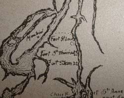
In 1665 the French began building a series of forts along the Richelieu River to protect New France from the Iroquois.[7] From north to south these were Fort Richelieu, Fort Chambly, and Fort Sainte Thérèse.
Four companies of the Carignan-Salières Regiment were sent from Québec to extend these forts further south, under Captain Pierre La Motte.[8] They built a trail connecting Fort Sainte Thérèse and Fort Saint-Louis (Chambly).[9]
In 1666 Fort Saint-Jean, and the furthest south Fort Sainte Anne, on Isle La Motte were added.[10] The fort included Saint Anne's Shrine. Both the fort and chapel were dedicated to Sainte Anne. In 1668, the bishop of Quebec, François de Laval, came to Isle La Motte to baptise a number of Iroqouis to Christianity. Even after the abandonment of the fort, the shrine continued to give mass to worshipers. The fort was the first European settlement in what is now Vermont.[11]
Fort St. Anne was the one most vulnerable to attack. The fort was garrisoned by about 300 French soldiers over the next four years, after which the troops were pulled back to Québec, destroying the fort before they left.
In the mid 1800s orchards, vineyards and dairy farms flourished on the island, which was then connected to the mainland by ferry during the warmer months and by foot or wagon over the ice in winter. In November of 1802, Isle La Motte was renamed to "Vineyard." However, 28 years later the original name was restored in November of 1803.[12] In 1878 the town was incorporated for the sole purpose of building a bridge to Alburgh. The bridge was completed in 1882.[13]
Fisk Farm was the site where Vermont Fish and Game League was addressed in August 1897 by President William McKinley and in September 1901 by Vice President Theodore Roosevelt when he learned of the eventually fatal shooting of President William McKinley.
Until around 1970, the island was on the main route from New England to Montreal via Route 2 until traffic was rerouted via the Interstate 89.
Geology and quarrying
The island, along with Valcour Island was formed 480 million years ago as a reef during the Ordovician Period in a shallow tropical sea, near where Zimbabwe is today. At that time there was no life on dry land except for a few primitive plants such as mosses and algae. Almost all of life was in the oceans. Carbon dioxide levels were 14–16 times higher than today with high sea levels covering much of the continents, which were mostly located south of the equator.[3] The stromatoporoid patch reef, one of the oldest known metazoan reefs, originally stretched a thousand miles from what is now Quebec to Tennessee but only a few remnants remain today.[3] The island's fossil reefs are part of the Chazy Fossil Reef, a National Natural Landmark dedicated in 2009.[14]
Reef builders during this period in earth history were principally bryozoa, stromatolites, stromatoporoids, sponges, and algae. Other marine life included cephalopods, gastropods, crinoids, and trilobites. Today fossil gastropods (snails) can be seen at the abandoned quarries.
Black limestone from the Chazy Formation was quarried on the island, the oldest quarry, behind Fisk Farm[15] started as early as 1832.
The limestone is composed of calcite and fossils of marine creatures. It is so dark in appearance that it was marketed in the 18th and 19th century as black marble and was used for the construction of the U.S. Capitol building and the National Gallery of Art. Structures made of the stone still visible on the island are: the Isle La Motte Public Library, the Isle La Motte Methodist Church, Isle La Motte Historical Society (formerly the South Stone School House), Ruins of the Fisk House at Fisk Farm, and the original Fisk House (once owned by Lieutenant Governor Nelson Fisk).
Demographics
| Historical population | |||
|---|---|---|---|
| Census | Pop. | %± | |
| 1800 | 135 | — | |
| 1810 | 623 | 361.5% | |
| 1820 | 312 | −49.9% | |
| 1830 | 459 | 47.1% | |
| 1840 | 435 | −5.2% | |
| 1850 | 476 | 9.4% | |
| 1860 | 564 | 18.5% | |
| 1870 | 497 | −11.9% | |
| 1880 | 505 | 1.6% | |
| 1890 | 551 | 9.1% | |
| 1900 | 608 | 10.3% | |
| 1910 | 510 | −16.1% | |
| 1920 | 385 | −24.5% | |
| 1930 | 352 | −8.6% | |
| 1940 | 335 | −4.8% | |
| 1950 | 295 | −11.9% | |
| 1960 | 238 | −19.3% | |
| 1970 | 262 | 10.1% | |
| 1980 | 393 | 50.0% | |
| 1990 | 408 | 3.8% | |
| 2000 | 488 | 19.6% | |
| 2010 | 471 | −3.5% | |
| Est. 2014 | 473 | [16] | 0.4% |
The town (and island) has a total area of 16.7 square miles (43.1 km2), of which 8.0 square miles (20.6 km2) is land and 8.7 square miles (22.5 km2) (52.22%) is water. Data for the town from the 2010 census:
- Residential population: 488 people
- Families: 143, average size 2.85
- Population density: 61.3 per square mile (23.7/km2).
- Housing units: 415 at an average density of 52.1 per square mile (20.1/km2).
- Self-declared race: 97.75% White, 1.23% Native American, 0.20% Asian, and 0.82% from two or more races.
- Households: 202, of which 27.7% had children under the age of 18 living with them, 59.4% were married couples, 8.4% had a female householder with no husband present, and 29.2% were non-families. 22.8% of all households were made up of individuals and 7.9% had someone living alone who was 65 years of age or older. The average household size was 2.42 .
- Demographics: the median age was 42 years. 25.0% under the age of 18, 4.3% from 18 to 24, 26.2% from 25 to 44, 27.3% from 45 to 64, and 17.2% who were 65 years of age or older. For every 100 females there were 93.7 males. For every 100 females age 18 and over, there were 92.6 males.
- Income: The per capita income for the town was $20,286. 7.7% of families and 9.4% of the population were below the poverty line, including 11.5% of those under age 18 and 2.5% of those age 65 or over. The median income for a household in the town was $36,125, and the median income for a family was $41,094. Males had a median income of $28,542 versus $24,000 for females.
References
- ↑ "American FactFinder". United States Census Bureau. Retrieved 2008-01-31.
- ↑ "Feature Detail Report for: Isle la Motte". United States Geological Survey. 1980-10-29. Retrieved 2015-10-15.
- 1 2 3 "Welcome to the Isle La Motte Preservation Trust!". Isle La Motte Preservation Trust. Retrieved 28 June 2015.
- ↑ "Isle La Motte Elementary School". Retrieved 28 June 2015.
- ↑ "Isle La Motte, VT". lighthousefriends.com. Retrieved 28 June 2015.
- ↑ "1st Report of the 1909 Champlain Tercentenary Celebration Commission". Hudson River Maritime Museum. 1908-03-23. Retrieved 2007-04-15.
- ↑ Hahn, Michael (February 2007). Vintage Cabin Fever: First Vermont Winter for Europeans. Northland Journal.
- ↑ Gannett, Henry (1905). The Origin of Certain Place Names in the United States. Govt. Print. Off. p. 166.
- ↑ "French-Canadian Exploration, Missionary Work, and Fur Trading in Hudson Bay, the Great Lakes, ..." (PDF). The French-Canadian Heritage Society of Michigan.
- ↑ Boréal Express (1977). Canada.Québec. Éditions du Renouveau Pédagogique Inc.
- ↑ Shulevitz, Judith (1990-08-05). "Champlain's Hideaway Islands". New York Times. Retrieved 2007-04-15.
- ↑ "History of Franklin and Grand Isle counties, Vermont : With illustrations and biographical sketches of some of the prominent men and pioneers.". p. 113.
- ↑ "Town of Isle La Motte, Vermont 05463". Town of Isle La Motte, Vermont 05463. Retrieved 28 June 2015.
- ↑ "Chazy Fossil Reef". National Natural Landmarks Program. National Park Service. June 28, 2012. Retrieved September 16, 2016.
- ↑ Teresi, Dick (January 2007). "Paleozoic Vermont". p. 26. Smithsonian Magazine. Retrieved 2007-04-15.
- ↑ "Annual Estimates of the Resident Population for Incorporated Places: April 1, 2010 to July 1, 2014". Retrieved June 4, 2015.
- ↑ "Census of Population and Housing". Census.gov. Retrieved June 4, 2015.
Municipalities and communities of Grand Isle County, Vermont, United States | ||
|---|---|---|
| Towns |  | |
| Village | ||