St Paul's Island
| Native name: <span class="nickname" ">Selmunett Gżira/Gżejjer ta' San Pawl | |
|---|---|
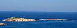 View of Saint Paul's Islands | |
| Geography | |
| Location | off Malta, south of Sicily, Mediterranean Sea |
| Coordinates | 35°57′55″N 14°24′2″E / 35.96528°N 14.40056°E |
| Archipelago | Maltese islands |
| Area | 0.101[1] km2 (0.039 sq mi) |
| Coastline | 0.9 km (0.56 mi) |
| Administration | |
| Demographics | |
| Population | 0 |
St Paul's Island, also known as Selmunett, is a small island off Selmun near the north-east of the main island of Malta. St Paul's Island is sometimes split into two islands by a shallow isthmus, and it is therefore sometimes referred to in the plural as St Paul's Islands. St Paul's Island has been uninhabited since World War II, and it is the largest uninhabited island of Malta, having an area of 0.1 square kilometres (0.04 square miles).[1]
History
_St._Paul's_Bay.jpg)
_09_ies.jpg)
The Acts of the Apostles tell the story of how Paul the Apostle was shipwrecked on an island which some scholars have identified as Malta while on his way to Rome to face charges. Traditionally, St. Paul's Bay and St Paul's Island are identified as the location for this shipwreck.[2]
Until 1575 the islands were named after the Salomone family, who owned a nearby land in Mellieha also called Selmun; the islands were named on maps as Isola Salomone and Isola Salomonetto and interpreted by the Maltese as Selmun and Selmunett. On other maps the islands were referred to as Selmun's Islands and The Scroll of Selmun. In 1576, Marco di Maria was being chased by Barbary corsairs off the coast of Malta. He navigated his vessel through the narrow channel between St Paul's Island and Malta, but when the pirates followed him they ran aground and were captured. As a result of this, the Grandmaster Jean de la Cassière gave St Paul's Islands to di Maria and the islands started to be called Tal-Barba Marku.[3][4]
After the death of Marco, as decreed by the Grand Master, the island passed to his family. It first went to his son Giovanni de Maria and later to the nephew of Marco who was the son of Giavanni, whom was named Narduccio de Maria. Narduccio lost his life in a battle at sea in a fight against the Ottomans. The island was then transferred to the Religion, as the Order's possession. Sometimes after 1649 a tower was build on the island by Grand Master Giovanni Paolo Lascaris. The tower was part of a contract, for the exchange of the island with the Casa della Giornata (now the site of the Royal Opera House) in Valletta that belonged to Michel de Torellas, the Prior of Catalonia.[5]
In 1844 a prominent statue of Saint Paul was erected on the island. It was sculpted by Segismondo Dimech from Valletta and Salvatore Dimech from Lija. The statue was officially inaugurated and blessed on 21 September 1845.[6] It was restored by Din l-Art Ħelwa a number of times, first in 1996, then in 2007,[7] in 2014,[8] and 2015.[9]
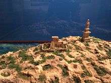
Until the 1930s, a farmer called Vincenzo Borg, nicknamed Ta' Bajdafin, lived on the island[10] in the tower built by Grandmaster Lascaris.[11] He converted and used it as a farmhouse. Borg abandoned the dwelling, and the fields on the island, just before World War II started. The tower was a three-chambered structure with a heavily buttressed wall at its lower level. It was built similar to other Lascaris towers. Since it was abandoned, the upper room has collapsed and the structure is now in ruins.[12]
Pope John Paul II visited the island by boat during his visit to Malta in 1990.[13][14] In the same year, a statue named Kristu tal-Baħħara was sunk near St. Paul’s Island. After 10 years, the statue was moved from St. Paul's Bay to Qawra point because of deteriorating visibility in the water and a decline in divers visiting the site.[15][16]
Geography
_04_ies.jpg)
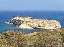
Saint Paul's Islands lie about 80 metres off the coast of Mellieħa, Malta. The island can split into two islands by a shallow isthmus according to the sea level, and when they are split the larger island on the west is known as Saint Paul's Island while the smaller one on the east is known as Quartz Island. Both islands are made of upper coralline limestone.
Saint Paul's Island's landscape is a maritime garigue dominated by Golden samphire, Maltese fleabane and other species. Quartz Island is more exposed and has less vegetation than the main island.[17]
A population of the land snail Trochoidea spratti can be found on the islands. Wild rabbits used to live on the island but the population died off due to disease.[18] A subspecies of the Maltese wall lizard known as Podarcis filfolensis kieselbachi also lived there but the population apparently became extinct in 2005.
References
| Wikimedia Commons has media related to St Paul's Islands. |
- 1 2 State of the Environment Report for Malta 1998
- ↑ "St. Paul in Malta". Visit Malta. Retrieved 26 August 2014.
- ↑ Camilleri, Alex. "Il-Mellieha u Madwara". It-Topografija ta' Malta. Melitensia. p. 175.
- ↑ "Your Pocket Guide to Mellieha". Places of Interest. Nature. p. 6-11. St. Paul's Islands. p. 8.
- ↑ Denaro, Victor F. (1959). Houses in Kingsway and Old Bakery Street, Valletta. Melita historica. Journal of the Malta Historical Society. 2 (4). p. 202.
- ↑ "Your Pocket Guide to Mellieha". Places of Interest. Nature. p. 6-11. St. Paul's Islands. p. 8.
- ↑ "St. Paul's Statue, St Paul's Island". Din l-Art Ħelwa. Retrieved 26 August 2014.
- ↑ "St Paul statue to be restored again". Times of Malta. 18 August 2014. Retrieved 26 August 2014.
- ↑ "St Paul's statue under repair after new weather damage". Times of Malta. 30 May 2015. Retrieved 30 May 2015.
- ↑ Said, Edward (17 September 2012). "Ancient farmhouse collapsing". Times of Malta. Retrieved 26 August 2014.
- ↑ Denaro, Victor F. (1959). Houses in Kingsway and Old Bakery Street, Valletta. Melita historica. Journal of the Malta Historical Society. 2 (4). p. 202.
- ↑ Said, Edward (17 September 2012). "Ancient farmhouse collapsing". Times of Malta. Retrieved 26 August 2014.
- ↑ Muscat, Jimmy. "Mellieħa - An Introduction to a Destination for All Seasons". Mellieħa Local Council. Retrieved 26 August 2014.
- ↑ "Your Pocket Guide to Mellieha". Places of Interest. Nature. p. 6-11. St. Paul's Islands. p. 8.
- ↑ George Cini (18 May 2000). Underwater statue moved to new site. The Times of Malta, p. 5.
- ↑ Mega dive. Times of Malta. 6 June 2010.
- ↑ "St. Paul's Islands (16)". Malta Environment & Planning Authority. Retrieved 26 August 2014.
- ↑ Grech, Gerald. "St. Paul's Islands". MaltaBookers.com. Retrieved 26 August 2014.
External links
| ||