Cedros Island
Coordinates: 28°10′58″N 115°13′04″W / 28.18278°N 115.21778°W

Cedros Island (Isla de Cedros, "island of cedars" in Spanish, also called in English Cerros Island in former times) is a Mexican island in the Pacific Ocean.
Geography
Cedros Island is located in Ensenada Municipality, off the west coast of the Mexican state of Baja California, from which it is separated by 100-kilometre (62 mi)-wide Sebastián Vizcaíno Bay. It is 22 km (14 mi) northwest of Punta Eugenia in Mulegé Municipality - the westernmost point of the state of Baja California Sur mainland. It also lies 15 km (9.32 mi) north of Isla Natividad (off Punta Eugenia, and also part of Mulegé Municipality) from which it is separated by the Canal de Keller, and some 500 km (311 mi) from San Diego.[1] The island has an area of 348.295 km2 (134.477 sq mi), being the fourth-largest island in Mexico (following Tiburón Island, Isla Ángel de la Guarda, and Cozumel).
Between Cedros Island and Isla Natividad runs the 28th parallel north, which defines the border between the Mexican states of Baja California and Baja California Sur. The Islas San Benito, about 25 km (16 mi) west and 3.899 km2 (1.505 sq mi) in area, are administratively part of Cedros Island.
The Isla de Cedros was named by early Spanish explorers who mistakenly associated the large amounts of redwood and cedar driftwood arriving with the California current for local pines visible on the crest of the island.
Population and settlements
It constitutes one of the 24 subdivisions (delegaciones) of the municipio of Ensenada. The 2005 census[2] showed a total population of 1,350 persons.
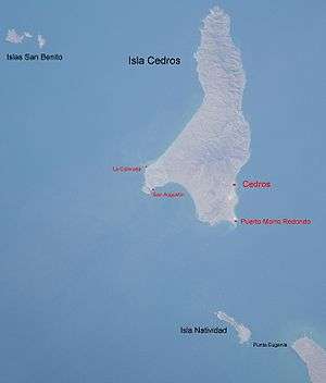
The borough "seat" is Cedros town ("Pueblo Cedros"), on the southern east coast. Pueblo Cedros is largely associated with Pescadores Nacionales de Abulón, the lobster and abalone fishing cooperative based on the island. It was founded by fishermen in 1922.
The second town is Puerto Morro Redondo (in short, El Morro), close to the southeastern point of the island, El Morro. It is a "company town," built by the joint Mexican Government and Mitsubishi Corporation to house the workers of the salt-transshipment facility on the island. Salt from the salt evaporation ponds of Guerrero Negro on the Baja California peninsula is taken by barge to a deepwater salt dock near Puerto Morro Redondo, at the south end of Cedros Island, where it is loaded onto ships for export. There is regularly scheduled air service to the island from Ensenada, departing every Monday and Wednesday, and landing at an airstrip at the south end, adjacent to the "company town," while a 10 km (6 mi) road leads to "Pueblo Cedros". Open launch rides across the channel between Cedros and the mainland can also be arranged at the Abarrotes Ramales store in Bahia Tortugas, but travellers opting for this transport should be prepared to have a flexible schedule with several extra days in case of inclement weather conditions in the Channel.
The remaining settlements are smaller. Jerusalem is just west of El Morro, but on the western side of the airport, with regularly arranged residential units. It is frequently considered part of El Morro.
Lomas Blancas, a mining town with 17 buildings, is located between Cedros town and El Morro.
San Agustín, a typical fishing village with about 20 buildings, is located 1 km (0.6 mi) northeast of the southwestern point of the island, Cabo San Agustín.
La Colorada, on the southern west coast, with about 10 buildings, is 4 km (2 mi) north of San Agustín.
Wayle, 15 buildings on the western side of the southern bight Bahía del Sur, is 3 km (1.9 mi) northeast of San Agustín.
The mining town of Punta Norte (about 25 buildings) is located on the northern east coast, 3.5 km (2.2 mi) southeast of the northern end of the island, which is also called Punta Norte. two kilometres (1 mi) to the southeast is Los Crestones mine.
List of settlements and locations:
- Cedros, 28°05′45.5″N 115°11′12.4″W / 28.095972°N 115.186778°W
- Puerto Morro Redondo, 28°02′18.6″N 115°11′12.0″W / 28.038500°N 115.186667°W
- Jerusalem, 28°02′24″N 115°11′29″W / 28.04000°N 115.19139°W
- Lomas Blancas, 28°04′44″N 115°11′07″W / 28.07889°N 115.18528°W
- San Agustín, 28°04′54.6″N 115°20′20.6″W / 28.081833°N 115.339056°W
- La Colorada, 28°07′01.2″N 115°21′07.0″W / 28.117000°N 115.351944°W
- Wayle, 28°05′34″N 115°18′47″W / 28.09278°N 115.31306°W
- Punta Norte, 28°21′15″N 115°11′39″W / 28.35417°N 115.19417°W
History
- Pre-Columbian era
Isla Cedros was home to some of the earliest occupants of the Pacific Coast of North America, and its later indigenous inhabitants had developed a way of life finely attuned to the conditions of this arid but resource-rich island. They had probably reached an overall population around 1,000-1,200 inhabitants by the time of European contact. These native peoples possessed sophisticated maritime technology and watercraft and depended largely on ocean resources for their livelihood.
These peoples were Cochimí speakers, related to the Native American tribes of Southern California, the lower Colorado River, and Western Arizona.
Currently, archaeological research into the indigenous history of the island is being conducted by researchers from California State University, Northridge and Oregon State University, under the direction of Dr. Matthew R. Des Lauriers. More than 70 archaeological sites have been identified, with several dating in excess of 10,000 years old.
- Spanish colonial period
In 1539, when the Spanish expedition led by Francisco de Ulloa landed on the island, it encountered several villages with populations at each estimated in the hundreds. Finding it difficult to reach the remaining Indians on the island, the Jesuit misionaries practiced Indian reductions and brought them all to Misión San Ignacio Kadakaamán, in San Ignacio on the Baja California mainland in 1732.
Hunters seeking seals and sea otters worked out the island between 1790 and 1850.
- 20th century
Gold and copper mining took place near Punta Norte between 1890 and 1917. The fishing village and cannery at Puerto Cedros were established in 1920. The fishing cooperative was founded in 1943, and the deepwater salt dock at the south end of the island was built in 1966. The island was mapped in detail by Mexican and U.S. geologists during the 1970s.
Natural history
Cedros Island is at most some 3 kilometres (1.9 mi) long in N-S direction and 6.4 to 8 kilometres (4 to 5 mi) wide in the northern half; the southern end is some 17 kilometres (11 mi) wide in a NW-SE direction.[3] The island consists of a variety of sedimentary, metamorphic, and igneous rocks, including part of an ophiolite complex and high-pressure, low temperature blueschists. Most of the rocks are of Mesozoic age, though some late Cenozoic strata crop out near the town in the southeastern corner of the island. Its highest peak, Monte Cedros, has an elevation of 1,205 metres (3,953 ft).
Flora
The island is often shrouded in fog, so that some plants have adapted to receiving moisture from fog. The west side of the island is windswept and subject to heavy surf; Pacific hurricanes are not unusual. The lower elevations, in particular the south, receive very little rainfall, and desert vegetation prevails. At higher elevations and in the north, there are trees like Quercus cedrosensis live oaks, California juniper,[4] and Monterey pines. Vargas or El Aguaje de Vargas is the most important spring with a flow of 180 drums of 200 lts or 55 US gal (208 l; 46 imp gal) each 12 hours; springs on the island are usually marked by groves of palm trees.
Fauna
Large sea lion colonies are found on the rocks on the west side as well as the anchorage on the north end.
There are feral goats on Cedros. Unlike on other islands in the region (notably Guadalupe Island), they do not seem to have had a significant impact on the island ecosystem. This would be due to the fact that Cedros is on the continental shelf close to the coast and, at least temporarily, it must have been connected to the mainland during the last ice age when sea levels were lower than today. Then, and as a consequence of this, there are native to Cedros herbivores, which on one hand compete with the goat population for food and presumably have kept it from increasing beyond carrying capacity, and on the other hand forced the native plants to keep their defenses against herbivores, unlike plants on megaherbivoreless islands which tend to lack those defenses.
Fishing is plentiful around Cedros Island. California yellowtail, subspecies of yellowtail amberjack, are very plentiful at this island because yellowtail breed there. These fish like to live in the kelp beds of the island. Other fish, such as calico bass and sheepshead are also very plentiful at this island.
Endemism
Cedros Island is home to a number of taxa that are endemic to or occur in very few places outside the island. These include:
- Animals
- [5]
- Cedros side-blotched lizard, Uta stansburiana concinna - endemic
- Cedros Island Bewick's wren, Thryomanes bewickii cerroensis - near-endemic[6]
- Cedros Island mule deer, Odocoileus hemionus cerrosensis - endemic
- Cedros Island brush rabbit, Sylvilagus bachmani cerrosensis - endemic -
- Cedros Island cactus mouse, Peromyscus eremicus cedrosensis - endemic -
- Plants
- [7]
- Cryptantha maritima var. cedrosensis - endemic
- Dudleya cedrosensis - endemic
- Dudleya pachyphytum - endemic
- Eriogonum molle - endemic
- Ferocactus chrysacanthus - endemic
- Harfordia macroptera ssp. fruticosa - endemic
- Leptodactylon veatchii - endemic
- Lotus cedrosensis - endemic
- Mammillaria goodridgei var. goodridgei - endemic
- Mammillaria goodridgei var. rectispina - endemic
- Mimulus stellatus - endemic
- Monardella thymifolia - endemic
- Penstemon cedrosensis - endemic
- Pinus radiata var. binata (Guadalupe Island Monterey pine) — near-endemic; possibly separable as var./ssp. cedrosensis and in this case endemic.
- Porophyllum cedrense - endemic
- Quercus cedrosensis (Cedros Island oak) — near-endemic
- Rhus integrifolia var. cedrosensis - endemic
- Salvia cedrosensis (Cedros Island sage) - endemic
- Senecio cedrosensis - endemic
- Verbesina hastata - endemic
- Xylonagra arborea ssp. arborea - endemic
In popular culture
The island is featured in the 2012 movie Act of Valor, in which U.S. Navy SEALs attack a terrorist training camp on the island.
See also
Footnotes
References
- California/Mexico Island Conservation Database (CMICD) (2007): Plant accounts: Guadalupe Island. Retrieved 2007-OCT-10.
- Instituto Nacional de Estadística, Geografía e Informática (INEGI) (2007): Principales resultados por localidad 2005 (ITER) ["Principal results of the 2005 census by locality"] [in Spanish]. Retrieved 2007-OCT-10.
- DigitalGlobe, Europa Technologies, NASA & TerraMetrics (2007): [Google Earth satellite image of Cedros Island]. Retrieved 2007-OCT-10.
- Thayer, John E. & Bangs, Outram (1907): Birds Collected by W. W. Brown, Jr., on Cerros [sic], San Benito and Natividad Islands in the Spring of 1906, with Notes on the Biota of the Islands. Condor 9(3): 77-81. doi:10.2307/1361136 PDF fulltext
- Des Lauriers, Matthew R., Island of Fogs: Archaeological and Ethnohistorical Investigations of Isla Cedros, Baja, 2010. ISBN 978-1-60781-007-0
- Land area of islands in Mexico INEGI
External links
| Wikimedia Commons has media related to Cedros Island— Isla de Cedros. |
- Mexico Desconocido Article in Spanish.
- Baja Quest Article about Cedros Island.
- Globe Trotters Travel Travelogs Travel experience to Cedros Island.
- Geologic Map
- Mining Map
- geology and minerals information