Ironwood, Michigan
| Ironwood, Michigan | |
|---|---|
| City | |
|
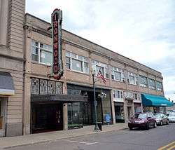
Downtown Ironwood | |
 Location of Ironwood, Michigan | |
| Coordinates: 46°27′21″N 90°9′34″W / 46.45583°N 90.15944°W | |
| Country | United States |
| State | Michigan |
| County | Gogebic |
| Area[1] | |
| • Total | 6.42 sq mi (16.63 km2) |
| • Land | 6.42 sq mi (16.63 km2) |
| • Water | 0 sq mi (0 km2) |
| Elevation | 1,506 ft (459 m) |
| Population (2010)[2] | |
| • Total | 5,387 |
| • Estimate (2012[3]) | 5,246 |
| • Density | 839.1/sq mi (324.0/km2) |
| Time zone | Central (CST) (UTC-6) |
| • Summer (DST) | CDT (UTC-5) |
| ZIP code | 49938 |
| Area code(s) | 906 |
| FIPS code | 26-41060[4] |
| GNIS feature ID | 0629087[5] |
| Website | www.cityofironwood.org |

Ironwood is a city in Gogebic County in the U.S. state of Michigan, about 18 miles (29 km) south of Lake Superior. The population was 5,387 at the 2010 census. The city is on US 2 and is situated opposite the Montreal River from Hurley, Wisconsin. It is the westernmost city in Michigan, situated on the same line of longitude (90.2 degrees West) as Clinton, Iowa and St. Louis, Missouri.
While originally an iron mining town, the area is now known for its downhill skiing resorts, including Big Powderhorn, Blackjack, Indianhead, Mount Zion and Whitecap as well as its cross country skiing at the Wolverine Nordic Trail System and the ABR Nordic Center.

Ironwood is home of the "World's Tallest Indian" : a 52 ft (15.8 m) fiberglass statue of tribal leader Hiawatha.
The city is at the south end of Ironwood Township, but is administratively autonomous.
History
The town of Ironwood was settled in the spring of 1885. The town was incorporated as a village in 1887 and as a city on April 8, 1889. The township area north of the city was incorporated as Ironwood Township on April 8, 1889. In 1890 the population of Ironwood passed 7500 and in 1900 it reached 10000.[6]
Iron ore was found in the area in the 1870s but it wasn't until the mid-1880s when the arrival of the railroad to the area opened it for more extensive exploration of the vast iron ore deposits. Soon several mines were discovered and opened such as the Norrie mine, Aurora mine, Ashland mine, Newport mine, and Pabst mine. The opening of the mines and the lumber works in the area led to a rapid influx of immigrants both from other parts of the USA and directly from Europe (mainly Sweden, Germany, England, Italy, Poland, Finland).
On September 17, 1887, a disastrous fire swept over half of the business portion of the town, although the buildings that were lost were quickly rebuilt. In 1926, the Pabst Mine Disaster took place, killing three miners and trapping 43 more for up to five days.
Its name's origin is usually considered to be from the following: James (Iron) Wood was a mining captain who worked for Fredrick Rhinelander. Arriving on the train to this wilderness camp, Mr. Rhinelander named the town in honor of his captain. There's a small park at the corner of North Suffolk and Fredrick Streets in honor of James Wood. Fredrick Street was in turn named after Fredrick Rhinelander for whom Rhinelander, Wisconsin was named.
In the early 1960s, the U.S. Air Force established a Strategic Air Command (SAC) Radar Bomb Scoring site atop Norrie hill to track and score simulated bomb runs by B-52s and B-47s on targets in the Ironwood area. It was used for both high altitude and treetop level bomb runs. A monument is erected south of Hurley, Wisconsin to remember those crew members killed in two B-47 low level runs. The site was moved to Charlevoix, Mi. in the mid 60's.
The religious life among the immigrants of different nationalities was very active. Already in the early 1890s there were twelve different churches in Ironwood.
- The Methodist Episcopal Church
- The Jessieville Methodist Episcopal Church
- St Ambrose Church (Catholic)
- St Michael's Church (Catholic)
- First Swedish Baptist Church
- Swedish Methodist Episcopal Church
- Swedish Mission Church (Covenant Church)
- Swedish Lutheran Church
- First Finnish Lutheran Church
- The First Presbyterian Church
- St Pauls Episcopal Church
- The First Apostolic Lutheran Church
Culture
Ironwood boasts a rich cultural life that includes two theater organizations Theatre North and Ironwood Theatre. Ironwood Dance Company produces shows throughout the year and sends dancers to compete at state and national competitions. The Ironwood Carnegie Library is the oldest operating Carnegie library in the state of Michigan. Each summer the Pine Mountain Music Festival brings top performances to Ironwood.
Literature
Ironwood and its famous pasties appear in Neil Gaiman's novel American Gods. Ironwood and the Ironwood region are central to folk novel Marvin & Me, by author and Ironwood native Rod Stockhaus.
Government
Ironwood's city government, like many other small Michigan communities, consists of a 5-member city council with the top vote receiver serving as Mayor. Day-to-day operations are the responsibility of the City Manager, who reports directly to the council during their two monthly, public meetings.
Public protection
The City of Ironwood operates a public safety department, in which all of the members are fully cross-trained and serve as both police officers and firefighters. Current city ordinances allow for a full-time staff of around twelve. Before 1989, the city had traditional, separate police and fire departments. IPSD, as the department is now known, continues to be the only full-time fire department in the Western Upper Peninsula. The Public Safety Department is also supplemented by the volunteer fire department which has been in operation since 1887. In response to a decade-long rise in tourism, the department now operates a snowmobile patrol unit from December to February, and a community-based foot patrol unit from May to September.
Education

Ironwood has one high school, Luther L. Wright High School, informally known as Ironwood High School. Their mascot is the "Red Devils," a common description of the iron ore miners that would get covered with red dust from the iron ore.[7] Luther L. Wright enjoys a rivalry with neighboring Hurley High. It is one of the longest-running interstate rivalries in American high school sports.
Ironwood was the home of the last parochial high school in Michigan's Upper Peninsula. Ironwood Catholic High School (formerly St. Ambrose School) closed after graduation of the senior class in 1985. The school's mascot was the ram, with the players known as the "Ramblers". The student yearbook was known as the "Loner" in recognition of its status as the last parochial school in this part of the state.
Ironwood is also the location of Gogebic Community College.
Transportation
Highways

- US Highway 2 runs west to Ashland, Wisconsin and Duluth, Minnesota, and runs east to Iron Mountain.
- Business US Highway 2 serves the city of Ironwood.
- M-28 begins in nearby Wakefield and runs east across the Upper Peninsula of Michigan to Marquette near Sault Ste. Marie, Michigan.
- Wisconsin State Highway 51 ends in nearby Hurley, Wisconsin.
- Wisconsin State Highway 77 starts just across the state line in Hurley and travels southwest.
- County Road 505 runs north (as Lake Road) through Ironwood Township and runs by Little Girl's Point County Park on Lake Superior and eventually meets the northern terminus of WIS 122 at the Michigan–Wisconsin border near Saxon Harbor, and runs south (as Van Buskirk Road) through Erwin Township to meet the terminus of CTH-C in Oma, WI.
- County Road 200 (Old County Road) begins at the east end of the city and runs east to Bessemer.
- County Road 501 (Junet Road) begins at the northwest end of the city and runs north to meet CR 204 (Airport Road)}.
Bus service
Indian Trails provides daily intercity bus service between St. Ignace and Ironwood[8] and between Ironwood and Duluth, Minnesota,[9] while Gogebic County operates a small public bus system.
Airport
Ironwood is served by the Gogebic-Iron County Airport (KIWD), which provides commercial air service. Air Choice One provides scheduled commercial service to Chicago O'Hare International Airport. Scheduled service to and from Minneapolis began on June 1, 2016.[10] Located (7) miles northeast of the city, the airport handles approximately 5,500 operations per year, with roughly 65% general aviation, 26% commercial service and 9% air taxi. The airport has a 6,502 foot asphalt runway with approved ILS, GPS and VOR/DME approaches (Runway 9-27). [11]
Trails
The Iron Belle Trail uses Ironwood as one of its terminus's for the cross-state hiking and biking trails.[12]
Communications
Newspapers
Radio stations
Television
Television stations serving Ironwood from Duluth
- KDLH 2 (The CW)
- KBJR-DT2 3 (CBS)
- KBJR 6 (NBC)
- WDSE 8 (PBS)
- KBJR-DT3 9 (MyNetworkTV)
- WDIO 10 (ABC)
- WDIO-DT2 10.2 (MeTV)
- KQDS 21 (Fox)
- KQDS-DT2 21.2 (Antenna TV)
Geography
According to the United States Census Bureau, the city has a total area of 6.42 square miles (16.63 km2), all of it land.[1] Ironwood is one of the snowiest places in Michigan, and has an average seasonal snowfall of 188.2 inches (478 cm). The deepest snow cover, 71 inches (180 cm), was measured on February 23, 1904.[13]
| Climate data for Ironwood, Michigan (1981-2010 normals, extremes 1901- present) | |||||||||||||
|---|---|---|---|---|---|---|---|---|---|---|---|---|---|
| Month | Jan | Feb | Mar | Apr | May | Jun | Jul | Aug | Sep | Oct | Nov | Dec | Year |
| Record high °F (°C) | 55 (13) |
62 (17) |
79 (26) |
88 (31) |
100 (38) |
99 (37) |
104 (40) |
101 (38) |
99 (37) |
86 (30) |
76 (24) |
59 (15) |
104 (40) |
| Average high °F (°C) | 20.3 (−6.5) |
25.2 (−3.8) |
35.6 (2) |
49.8 (9.9) |
63.0 (17.2) |
71.9 (22.2) |
76.1 (24.5) |
74.5 (23.6) |
65.8 (18.8) |
52.4 (11.3) |
36.9 (2.7) |
24.2 (−4.3) |
49.64 (9.8) |
| Daily mean °F (°C) | 11.6 (−11.3) |
14.9 (−9.5) |
25.1 (−3.8) |
39.3 (4.1) |
51.9 (11.1) |
61.3 (16.3) |
65.8 (18.8) |
64.1 (17.8) |
55.7 (13.2) |
43.4 (6.3) |
29.8 (−1.2) |
16.6 (−8.6) |
39.96 (4.43) |
| Average low °F (°C) | 2.9 (−16.2) |
4.7 (−15.2) |
14.6 (−9.7) |
28.8 (−1.8) |
40.9 (4.9) |
50.7 (10.4) |
55.5 (13.1) |
53.7 (12.1) |
45.5 (7.5) |
34.4 (1.3) |
22.7 (−5.2) |
9.1 (−12.7) |
30.29 (−0.96) |
| Record low °F (°C) | −41 (−41) |
−41 (−41) |
−34 (−37) |
−12 (−24) |
13 (−11) |
25 (−4) |
31 (−1) |
30 (−1) |
21 (−6) |
2 (−17) |
−18 (−28) |
−36 (−38) |
−41 (−41) |
| Average precipitation inches (mm) | 1.93 (49) |
1.27 (32.3) |
1.98 (50.3) |
2.64 (67.1) |
3.13 (79.5) |
3.66 (93) |
4.10 (104.1) |
3.37 (85.6) |
4.06 (103.1) |
3.98 (101.1) |
2.70 (68.6) |
2.11 (53.6) |
34.93 (887.3) |
| Average snowfall inches (cm) | 44.2 (112.3) |
28.2 (71.6) |
24.9 (63.2) |
11.4 (29) |
1.9 (4.8) |
0 (0) |
0 (0) |
0 (0) |
0.2 (0.5) |
6.6 (16.8) |
24.5 (62.2) |
46.3 (117.6) |
188.2 (478) |
| Source: NOAA[14] | |||||||||||||
Demographics
| Historical population | |||
|---|---|---|---|
| Census | Pop. | %± | |
| 1890 | 7,745 | — | |
| 1900 | 9,705 | 25.3% | |
| 1910 | 12,821 | 32.1% | |
| 1920 | 15,739 | 22.8% | |
| 1930 | 14,299 | −9.1% | |
| 1940 | 13,369 | −6.5% | |
| 1950 | 11,466 | −14.2% | |
| 1960 | 10,265 | −10.5% | |
| 1970 | 8,711 | −15.1% | |
| 1980 | 7,741 | −11.1% | |
| 1990 | 6,849 | −11.5% | |
| 2000 | 6,293 | −8.1% | |
| 2010 | 5,387 | −14.4% | |
| Est. 2015 | 5,002 | [15] | −7.1% |
2010 census
As of the census[2] of 2010, there were 5,387 people, 2,520 households, and 1,408 families residing in the city. The population density was 839.1 inhabitants per square mile (324.0/km2). There were 3,175 housing units at an average density of 494.5 per square mile (190.9/km2). The racial makeup of the city was 96.0% White, 0.5% African American, 1.1% Native American, 0.2% Asian, 0.3% from other races, and 1.8% from two or more races. Hispanic or Latino of any race were 1.2% of the population.
There were 2,520 households of which 23.8% had children under the age of 18 living with them, 38.5% were married couples living together, 12.3% had a female householder with no husband present, 5.1% had a male householder with no wife present, and 44.1% were non-families. 38.5% of all households were made up of individuals and 17% had someone living alone who was 65 years of age or older. The average household size was 2.09 and the average family size was 2.72.
The median age in the city was 45.5 years. 19.3% of residents were under the age of 18; 8.6% were between the ages of 18 and 24; 21.7% were from 25 to 44; 28.7% were from 45 to 64; and 21.7% were 65 years of age or older. The gender makeup of the city was 48.1% male and 51.9% female.
2000 census
As of the census[4] of 2000, there were 6,293 people, 2,841 households, and 1,625 families residing in the city. The population density was 960.3 per square mile (371.0/km²). There were 3,349 housing units at an average density of 511.0 per square mile (197.4/km²). The racial makeup of the city was 97.52% White, 0.10% African American, 0.72% Native American, 0.22% Asian, 0.14% from other races, and 1.30% from two or more races. Hispanic or Latino of any race were 0.83% of the population.
The ancestral makeup of the population were 24.7% Finnish, 17.0% German, 14.8% Italian, 12.6% Polish, 10.4% English and 9.5% Swedish.
There were 2,841 households out of which 24.9% had children under the age of 18 living with them, 42.4% were married couples living together, 11.2% had a female householder with no husband present, and 42.8% were non-families. 37.9% of all households were made up of individuals and 20.8% had someone living alone who was 65 years of age or older. The average household size was 2.16 and the average family size was 2.84.
In the city the population was spread out with 22.2% under the age of 18, 7.9% from 18 to 24, 23.6% from 25 to 44, 21.8% from 45 to 64, and 24.5% who were 65 years of age or older. The median age was 42 years. For every 100 females there were 89.1 males. For every 100 females age 18 and over, there were 86.3 males.
The median income for a household in the city was $23,502, and the median income for a family was $30,349. Males had a median income of $26,992 versus $21,184 for females. The per capita income for the city was $14,131. About 17.0% of families and 18.5% of the population were below the poverty line, including 24.2% of those under age 18 and 12.4% of those age 65 or over.
Notable people
- Raymond Joseph Cannon, U.S. Representative from Wisconsin, attorney for Shoeless Joe Jackson and several of the Chicago Black Sox
- William S. Carlson, President of the University of Delaware, the University of Vermont, the State University of New York, and the University of Toledo
- Agnes Charbonneau, member of the Wisconsin State Assembly[17]
- Jack Gotta, Canadian Football League player, coach, and general manager
- William C. Gribble, Jr., United States Army Chief of Engineers. As commander of the US Army Corps of Engineers, began the tradition of the Gold Castles insignia which forms the basis for the current "Castle" logo of the Corps
- John Regeczi, football player and teammate of future president Gerald Ford on the University of Michigan undefeated national championship teams in 1932 and 1933
Recurrent events and notable sights
There are a number of recurrent events. A calendar is available.[18] Chief among them are:
- Festival Ironwood
- Gogebic County Fair
- Jack Frost Festival of Lights Parade
- Lake Street mud run
- SISU cross country ski race
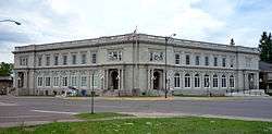
The Ironwood Memorial Building is located at the corners of McLeod and Marquette streets. It is a lavish 1923 Beaux arts municipal building. It contains extensive stained glass, murals, original light fixtures, and exhibits of artifacts and memorability on local history. An interesting display on the Gogebic Range's social history is upstairs. Ironwood city offices are quartered there and an ostentatious civic auditorium are in the building. Its main theme is the commemoration of local World War I veterants—1580 Gogebic area men perished in the war. This is one of several ostentatious buildings in the region paid for by copper companies.[19] Copper Peak is the largest ski jump in North America. There hasn't been any competition since 1994. However, it will be renovated and become the world's largest summer ski jump.[20]
 Suffolk Street around 1910.
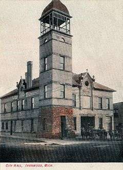 The City Hall about 1905.
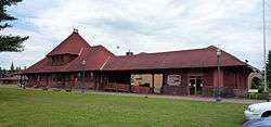
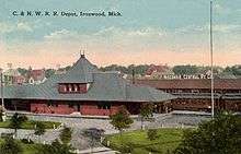 The Railroad Depot around 1910.
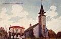 St Ambrose Church around 1910.
 The Aurora Mine before 1910.
 The Norrie Mine before 1910.
 The Newport Mine before 1910.
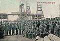 Miners at the Norrie Mine around 1905.
 Mining scene from Ironwood around 1905.
 Mining scene from Ironwood around 1905.
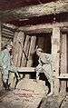 Mining scene from Ironwood around 1905.
 Mining scene from Ironwood around 1905.
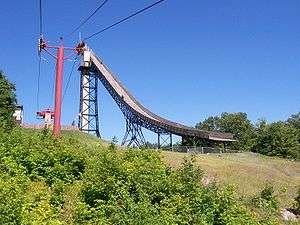 The ski flying hill
References
- 1 2 "US Gazetteer files 2010". United States Census Bureau. Retrieved 2012-11-25.
- 1 2 "American FactFinder". United States Census Bureau. Retrieved 2012-11-25.
- ↑ "Population Estimates". United States Census Bureau. Retrieved 2013-06-03.
- 1 2 "American FactFinder". United States Census Bureau. Retrieved 2008-01-31.
- ↑ U.S. Geological Survey Geographic Names Information System: Ironwood, Michigan
- ↑ Ironwood, Michigan. The Growing Years 1885–1925. The Centennial edition, 1985.
- ↑ "Ironwood Area School District - Ironwood, MI". ironwood.k12.mi.us.
- ↑ "ST. IGNACE-SAULT STE. MARIE-IRONWOOD" (PDF). Indian Trails. January 15, 2013. Retrieved 2013-02-28.
- ↑ "IRONWOOD-HURLEY-ASHLAND-DULUTH" (PDF). Indian Trails. January 15, 2013. Retrieved 2013-02-28.
- ↑ "Air Choice One to offer flights to Minneapolis". The Daily Globe. Retrieved 2016-04-08.
- ↑ http://www.airnav.com/airports/kiwd
- ↑ "FAQ about Michigan's Iron Belle Trail". Michigan DNR. February 7, 2015. Retrieved February 7, 2015.
- ↑ http://w2.weather.gov/climate/xmacis.php?wfo=mqt
- ↑ "Ironwood 1981-2010 normals". NOAA NowData. 2016. Retrieved on September 14, 2016.
- ↑ "Annual Estimates of the Resident Population for Incorporated Places: April 1, 2010 to July 1, 2015". Retrieved July 2, 2016.
- ↑ "Census of Population and Housing". Census.gov. Retrieved June 4, 2015.
- ↑ 'Wisconsin Blue Book 1931,' Biographical Sketch of Agnes Charbonneau,pg. 219
- ↑ "Ironwood Blog". Ironwood Blog.
- ↑ "Ironwood Memorial Building". Hunts Upper Peninsula Guide. Retrieved August 12, 2011..
- ↑ "Copper Peak to be reinvented as world's largest summer ski Jump". Ski Jumping Hill Archive » skisprungschanzen.com.
External links
| Wikimedia Commons has media related to Ironwood, Michigan. |
Municipalities and communities of Gogebic County, Michigan, United States | ||
|---|---|---|
| Cities | 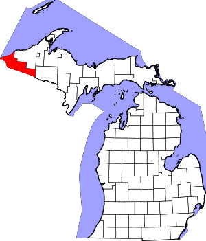 | |
| Charter township | ||
| General law townships | ||
| CDPs | ||
| Unincorporated communities | ||
| Indian reservation | ||
Coordinates: 46°27′17″N 90°10′16″W / 46.45472°N 90.17111°W