Iron County, Missouri
| Iron County, Missouri | |
|---|---|
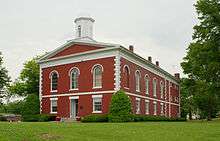 County courthouse in Ironton | |
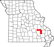 Location in the U.S. state of Missouri | |
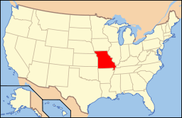 Missouri's location in the U.S. | |
| Founded | February 17, 1857 |
| Named for | Iron ore |
| Seat | Ironton |
| Largest city | Ironton |
| Area | |
| • Total | 552 sq mi (1,430 km2) |
| • Land | 550 sq mi (1,424 km2) |
| • Water | 1.8 sq mi (5 km2), 0.3% |
| Population (est.) | |
| • (2015) | 10,125 |
| • Density | 19/sq mi (7/km²) |
| Congressional district | 8th |
| Time zone | Central: UTC-6/-5 |
Iron County is a county located in the Lead Belt region in the U.S. state of Missouri. As of the 2010 census, the population was 10,630.[1] The largest city and county seat is Ironton.[2] Iron County was officially organized on February 17, 1857, and was named after the abundance of iron ore found within its borders.[3][4]
Iron County includes the 6-mile (9.7 km)-long, 2-mile (3.2 km)-wide Arcadia Valley, the site of Pilot Knob, Ironton, and Arcadia, communities established by immigrants in the 19th Century.[5] The valley is surrounded by the Saint Francois Mountains of the Ozarks Plateau. Iron County is also home to dozens of mountains,[6] including the 1,772-foot (540 m) Taum Sauk Mountain, the highest point in Missouri.
The county is home to a number of state parks and historical sites including Taum Sauk Mountain State Park, Elephant Rocks State Park and Fort Davidson State Historic Site as well as 96,047 acres (390 km2) of Mark Twain National Forest.[7]
Geography
According to the U.S. Census Bureau, the county has a total area of 552 square miles (1,430 km2), of which 550 square miles (1,400 km2) is land and 1.8 square miles (4.7 km2) (0.3%) is water.[8]
Adjacent counties
- Washington County (north)
- St. Francois County (northeast)
- Madison County (east)
- Wayne County (southeast)
- Reynolds County (southwest)
- Dent County (west)
- Crawford County (northwest)
National protected areas
Demographics
| Historical population | |||
|---|---|---|---|
| Census | Pop. | %± | |
| 1860 | 5,842 | — | |
| 1870 | 6,278 | 7.5% | |
| 1880 | 8,183 | 30.3% | |
| 1890 | 9,119 | 11.4% | |
| 1900 | 8,716 | −4.4% | |
| 1910 | 8,563 | −1.8% | |
| 1920 | 9,458 | 10.5% | |
| 1930 | 9,642 | 1.9% | |
| 1940 | 10,440 | 8.3% | |
| 1950 | 9,458 | −9.4% | |
| 1960 | 8,041 | −15.0% | |
| 1970 | 9,529 | 18.5% | |
| 1980 | 11,084 | 16.3% | |
| 1990 | 10,726 | −3.2% | |
| 2000 | 10,697 | −0.3% | |
| 2010 | 10,630 | −0.6% | |
| Est. 2015 | 10,125 | [9] | −4.8% |
| U.S. Decennial Census[10] 1790-1960[11] 1900-1990[12] 1990-2000[13] 2010-2015[1] | |||
As of the census[14] of 2000, there were 10,697 people, 4,197 households, and 2,963 families residing in the county. The population density was 7/km² (19/mi²). There were 4,907 housing units at an average density of 3/km² (9/mi²). The racial makeup of the county was 96.74% White, 1.56% Black or African American, 0.34% Native American, 0.09% Asian, 0.22% from other races, and 1.05% from two or more races. Approximately 0.58% of the population were Hispanic or Latino of any race.
There were 4,197 households out of which 32.00% had children under the age of 18 living with them, 56.80% were married couples living together, 9.40% had a female householder with no husband present, and 29.40% were non-families. 25.80% of all households were made up of individuals and 11.40% had someone living alone who was 65 years of age or older. The average household size was 2.46 and the average family size was 2.94.
In the county the population was spread out with 25.00% under the age of 18, 7.80% from 18 to 24, 25.30% from 25 to 44, 24.80% from 45 to 64, and 17.10% who were 65 years of age or older. The median age was 40 years. For every 100 females there were 94.80 males. For every 100 females age 18 and over, there were 90.80 males.
The median income for a household in the county was $31,276, and the median income for a family was $38,037. Males had a median income of $28,603 versus $16,615 for females. The per capita income for the county was $16,717. About 13.80% of families and 19.00% of the population were below the poverty line, including 27.60% of those under age 18 and 13.20% of those age 65 or over.
Religion
According to the Association of Religion Data Archives County Membership Report (2000), Iron County is a part of the Bible Belt with evangelical Protestantism being the majority religion. The most predominant denominations among residents in Iron County who adhere to a religion are Southern Baptists (56.62%), Methodists (10.60%), and Roman Catholics (7.82%).
Politics
Local
The Democratic Party mostly controls politics at the local level in Iron County. Democrats hold 11 of the 14 positions in the county.
| Iron County, Missouri | ||||
|---|---|---|---|---|
| Elected countywide officials | ||||
| Assessor | David L. Huff | Democratic | ||
| Circuit Clerk | Sammye (Gail) White | Democratic | ||
| County Clerk | Virginia Queen | Democratic | ||
| Collector | Linda Kemp | Democratic | ||
| Commissioner (Presiding) |
Jim Scaggs | Democratic | ||
| Commissioner (District 1) |
Dwayne Warncke | Democratic | ||
| Commissioner (District 2) |
Joshua Campbell | Republican | ||
| Coroner | Tim Harbison | Republican | ||
| Prosecuting Attorney | Brian Parker | Democratic | ||
| Public Administrator | Lisa Light | Republican | ||
| Recorder | Karen K. Reagan | Democratic | ||
| Sheriff | Roger D. Medley | Democratic | ||
| Surveyor | Mark Nations | Democratic | ||
| Treasurer | Carol Hardy | Democratic | ||
State
In the Missouri House of Representatives, all of Iron County is a part of Missouri’s 144th District and is currently represented by Republican Paul Fitzwater of Potosi. Fitzwater was elected in 2016 to his fourth and final term in the Missouri House.
In the Missouri Senate, all of Iron County is a part of Missouri’s 3rd District and is currently represented by Republican Gary Romine of Farmington. Romine defeated former Democratic State Representative Joseph Fallert, Jr. of Ste. Genevieve in 2012 with 53.84 percent of the vote in the district, which includes most of the Missouri Lead Belt region. The seat was vacated by former Republican State Senator Kevin Engler of Farmington. Engler successfully served two terms/eight years in the Missouri Senate and was ineligible to seek a third term due to term limits.
| Year | Republican | Democratic | Third Parties |
|---|---|---|---|
| 2016 | 60.76% 2,600 | 34.99% 1,497 | 4.25% 182 |
| 2012 | 39.87% 1,596 | 56.91% 2,278 | 3.22% 129 |
| 2008 | 33.45% 1,483 | 64.14% 2,844 | 2.41% 107 |
| 2004 | 50.62% 2,359 | 47.53% 2,215 | 2.85% 86 |
| 2000 | 45.42% 2,002 | 51.23% 2,258 | 3.35% 148 |
| 1996 | 35.54% 1,470 | 62.60% 2,589 | 1.86% 77 |
| 1992 | 37.07% 1,653 | 62.93% 2,806 | 0.00% 0 |
| 1988 | 55.65% 2,290 | 44.16% 1,817 | 0.19% 8 |
| 1984 | 50.01% 2,127 | 49.99% 2,126 | 0.00% 0 |
| 1980 | 51.18% 2,322 | 48.62% 2,206 | 0.20% 9 |
| 1976 | 46.76% 2,043 | 52.99% 2,315 | 0.25% 11 |
| 1972 | 51.80% 1,840 | 48.86% 1,760 | 0.06% 2 |
| 1968 | 33.82% 1,246 | 66.18% 2,438 | 0.00% 0 |
| 1964 | 28.59% 1,066 | 71.41% 2,662 | 0.00% 0 |
| 1960 | 38.41% 1,465 | 61.59% 2,349 | 0.00% 0 |
Federal
Missouri's two U.S. Senators are Democrat Claire McCaskill of Kirkwood and Republican Roy Blunt of Strafford.
McCaskill was reelected to her second term in 2012 with 54.81 percent of the statewide vote over former Republican U.S. Representative W. Todd Akin of Town & Country and Libertarian Jonathan Dine of Riverside; Iron County voters backed McCaskill with 56 and a quarter percent of the vote.
| Party | Candidate | Votes | % | ± | |
|---|---|---|---|---|---|
| Democratic | Claire McCaskill | 2,252 | 56.27 | ||
| Republican | W. Todd Akin | 1,461 | 36.51 | ||
| Libertarian | Jonathan Dine | 289 | 7.22 | ||
Blunt was re-elected in 2016 with 49.3 percent of the statewide vote over Democratic Missouri Secretary of State Jason Kander, Libertarian Jonathan Dine of Riverside, Constitutionalist Fred Ryman, and Green Party candidate Johnathan McFarland; Iron County voters supported Blunt with over 55 percent of the vote.
| Party | Candidate | Votes | % | ± | |
|---|---|---|---|---|---|
| Republican | Roy Blunt | 2,329 | 55.10 | ||
| Democratic | Jason Kander | 1,671 | 39.53 | ||
| Libertarian | Jonathan Dine | 102 | 2.41 | ||
| Green | Johnathan McFarland | 79 | 1.87 | ||
| Constitution | Fred Ryman | 46 | 1.09 | ||
All of Iron County is included in Missouri's 8th Congressional District and is currently represented by Republican Jason T. Smith of Salem in the U.S. House of Representatives. Smith won a special election on Tuesday, June 4, 2013, to complete the remaining term of former Republican U.S. Representative Jo Ann Emerson of Cape Girardeau. Emerson announced her resignation a month after being reelected with over 70 percent of the vote in the district. She resigned to become CEO of the National Rural Electric Cooperative.
| Party | Candidate | Votes | % | ± | |
|---|---|---|---|---|---|
| Republican | Jo Ann Emerson | 2,741 | 69.01 | +15.84 | |
| Democratic | Jack Rushin | 1,113 | 28.02 | -13.51 | |
| Libertarian | Rick Vandeven | 118 | 2.97 | +0.19 | |
| Party | Candidate | Votes | % | ± | |
|---|---|---|---|---|---|
| Republican | Jason T. Smith | 409 | 52.44 | ||
| Democratic | Steve Hodges | 229 | 43.46 | ||
| Constitution | Doug Enyart | 20 | 2.56 | ||
| Libertarian | Bill Slantz | 6 | 0.77 | ||
| Write-in | Thomas Brown | 6 | 0.77 | ||
Political culture
| Year | Republican | Democratic | Third Parties |
|---|---|---|---|
| 2016 | 74.36% 3,173 | 21.87% 933 | 3.77% 161 |
| 2012 | 55.87% 2,252 | 41.40% 1,669 | 2.73% 110 |
| 2008 | 47.35% 2,090 | 50.14% 2,213 | 2.51% 111 |
| 2004 | 52.94% 2,477 | 46.10% 2,157 | 0.96% 45 |
| 2000 | 50.68% 2,237 | 46.31% 2,044 | 3.01% 133 |
| 1996 | 31.92% 1,328 | 53.39% 2,221 | 14.69% 611 |
| 1992 | 27.54% 1,276 | 54.10% 2,507 | 18.15% 841 |
| 1988 | 45.01% 1,877 | 54.75% 2,283 | 0.24% 10 |
| 1984 | 53.38% 2,316 | 46.62% 2,023 | 0.00% 0 |
| 1980 | 48.45% 2,205 | 48.91% 2,226 | 2.64% 120 |
| 1976 | 39.81% 1,765 | 59.68% 2,646 | 0.52% 23 |
| 1972 | 62.07% 2,203 | 37.93% 1,346 | 0.00% 0 |
| 1968 | 41.60% 1,600 | 45.63% 1,755 | 12.77% 491 |
| 1964 | 27.78% 1,050 | 72.22% 2,730 | 0.00% 0 |
| 1960 | 53.41% 2,122 | 46.59% 1,851 | 0.00% 0 |
Historically, Iron County has been one of the most reliably Democratic counties in Missouri. Located in the Lead Belt region of the state, mining has been important to the county's economy. It was one of only three predominantly rural counties in Missouri to vote for Barack Obama in 2008 (nearby Washington and Ste. Genevieve counties being the other two). While Republican George W. Bush did manage to carry Iron County in 2000 and 2004, the margins of victory were significantly smaller than in many of the other rural areas. Like elsewhere in the state, Iron County saw a rapid rightward swing in 2012 when former Republican Governor of Massachusetts Mitt Romney carried the county by approximately 15 points. At the local and state levels, however, Iron County still remains quite Democratic. At the same time Romney won Iron County by 15 points in 2012, all Democratic statewide candidates Jay Nixon (Governor), Claire McCaskill (U.S. Senator), Jason Kander (Secretary of State), Chris Koster (Attorney General), and Clint Zweifel (State Treasurer) carried Iron County by healthy margins; Peter Kinder (Lieutenant Governor) was the only other statewide Republican to win Iron County alongside Romney, and even then, the margin of victory was smaller than in most other rural counties.
Like most rural areas throughout Southeast Missouri, voters in Iron County generally adhere to socially and culturally conservative principles but are more moderate or populist on economic issues. In 2004, Missourians voted on a constitutional amendment to define marriage as the union between a man and a woman—it overwhelmingly passed Iron County with 80.90 percent of the vote. The initiative passed the state with 71 percent of support from voters as Missouri became the first state to ban same-sex marriage. In 2006, Missourians voted on a constitutional amendment to fund and legalize embryonic stem cell research in the state—it failed in Iron County with 56.03 percent voting against the measure. The initiative narrowly passed the state with 51 percent of support from voters as Missouri became one of the first states in the nation to approve embryonic stem cell research. Despite Iron County’s longstanding tradition of supporting socially conservative platforms, voters in the county have a penchant for advancing populist causes like increasing the minimum wage. In 2006, Missourians voted on a proposition (Proposition B) to increase the minimum wage in the state to $6.50 an hour—it passed Iron County with 78.25 percent of the vote. The proposition strongly passed every single county in Missouri with 75.94 percent voting in favor as the minimum wage was increased to $6.50 an hour in the state. During the same election, voters in five other states also strongly approved increases in the minimum wage.
Missouri Presidential Preference Primary (2008)
In the 2008 Missouri Presidential Preference Primary, voters in Iron County from both political parties supported candidates who finished in second place in the state at large and nationally.
- Former U.S. Senator Hillary Clinton (D-New York) received more votes, a total of 1,180, than any candidate from either party in Iron County during the 2008 Missouri Presidential Primaries. She also received more votes altogether than the total number of votes cast in the entire Republican Primary in Iron County.
| Iron County, Missouri | ||
|---|---|---|
| 2008 Republican primary in Missouri | ||
| John McCain | 269 (32.80%) | |
| Mike Huckabee | 354 (43.17%) | |
| Mitt Romney | 138 (16.83%) | |
| Ron Paul | 43 (5.24%) | |
| Iron County, Missouri | ||
|---|---|---|
| 2008 Democratic primary in Missouri | ||
| Hillary Clinton | 1,180 (70.53%) | |
| Barack Obama | 406 (24.27%) | |
| John Edwards (withdrawn) | 72 (4.30%) | |
Education
Of adults 25 years of age and older in Iron County, 65.2% possesses a high school diploma or higher while 8.4% holds a bachelor's degree or higher as their highest educational attainment.
Public schools
- Arcadia Valley School District - Ironton
- Arcadia Valley Elementary School (PK-04)
- Arcadia Valley Middle School (05-08)
- Arcadia Valley High School (09-12)
- Belleview R-III Elementary School - Belleview - (K-08)
- Iron County C-4 School District - Viburnum
- Viburnum Elementary School (K-06)
- Viburnum High School (07-12)
- South Iron County R-I School District - Annapolis
- South Iron County Elementary School (PK-06)
- South Iron County High School (07-12)
Vocational/technical schools
- Arcadia Valley Career Technical Center - Ironton - (09-12)
Transportation
State highways
Railroads
- The Iron Mountain Railroad,[15] later incorporated into Union Pacific, runs through Arcadia Valley. Plans are underway to construct a train station in Arcadia to serve Amtrak's Texas Eagle.
Communities
See also
References
- 1 2 "State & County QuickFacts". United States Census Bureau. Retrieved September 9, 2013.
- ↑ "Find a County". National Association of Counties. Retrieved 2011-06-07.
- ↑ Eaton, David Wolfe (1916). How Missouri Counties, Towns and Streams Were Named. The State Historical Society of Missouri. p. 176.
- ↑ Gannett, Henry (1905). The Origin of Certain Place Names in the United States. Govt. Print. Off. p. 166.
- ↑ “The Arcadia Country” ca. 1920 from the Western Historical Manuscript Collection of Missouri S&T
- ↑ Summits of Iron County from TopoZone
- ↑ "Acreage by State, Congressional District and County Report". U.S. Forest Service. 2007-10-10. Retrieved 2008-11-18.
- ↑ "2010 Census Gazetteer Files". United States Census Bureau. August 22, 2012. Retrieved November 16, 2014.
- ↑ "County Totals Dataset: Population, Population Change and Estimated Components of Population Change: April 1, 2010 to July 1, 2015". Retrieved July 2, 2016.
- ↑ "U.S. Decennial Census". United States Census Bureau. Retrieved November 16, 2014.
- ↑ "Historical Census Browser". University of Virginia Library. Retrieved November 16, 2014.
- ↑ "Population of Counties by Decennial Census: 1900 to 1990". United States Census Bureau. Retrieved November 16, 2014.
- ↑ "Census 2000 PHC-T-4. Ranking Tables for Counties: 1990 and 2000" (PDF). United States Census Bureau. Retrieved November 16, 2014.
- ↑ "American FactFinder". United States Census Bureau. Retrieved 2008-01-31.
- ↑ H.R. 1424, an Act of Congress dated July 13, 1868, from the American Memory website
External links
- Iron County from the Western Historical Manuscript Collection of Missouri University of Science and Technology
- Plat book of Iron County from the Missouri Digital Heritage website of the Missouri Secretary of State
- Iron County Sheriff's Office
 |
Crawford County | Washington County | St. Francois County | |
| Dent County | |
Madison County | ||
| ||||
| | ||||
| Reynolds County | Wayne County |
Municipalities and communities of Iron County, Missouri, United States | ||
|---|---|---|
| Cities | | |
| Village | ||
| Townships | ||
| Unincorporated communities | ||
| Ghost towns | ||
| Footnotes | ‡This populated place also has portions in an adjacent county or counties | |
Coordinates: 37°33′N 90°46′W / 37.55°N 90.76°W