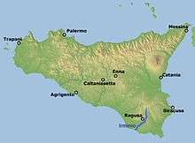
Irminio
| Irminio | |
|---|---|
 Map of the Irminio. | |
| Country | Italy |
| Basin | |
| Main source |
Monte Lauro Hyblaean Mountains 986 m (3,235 ft) |
| River mouth | Mediterranean Sea |
| Basin size | 254.56 km2 (98.29 sq mi) |
| Physical characteristics | |
| Length | 55 km (34 mi) |
The Irminio is a 55-kilometre (34 mi) long river located in south-eastern Sicily and is also the most important of the rivers of the province of Ragusa.
The river springs from Monte Lauro, the main peak of the Hyblaean Mountains, which form the main part of the mountainous southeast of Sicily and runs across the province from north-east to south-west before flowing into the Mediterranean Sea 2.5 kilometres (1.6 mi) east of Marina di Ragusa. Its main affluences are the streams Cava Volpe, Ciaramite, Mastratto, and near Ragusa Ibla the streams San Leonardo and Santa Domenica.
Natural reserves
Halfway through its course the river is housing a small area classified as Oasi Irminio for the brown trout and at its mouth the Natural reserve Macchia Foresta del fiume Irminio of 134 hectares (330 acres).
Dam
The 10 November 1976 works started to build a dam along the river in the area between Ragusa and Giarratana. The structure, 57.10 metres (187.3 ft) tall, was completed in 1983 to create the Lago di Santa Rosalia, a reservoir for agricultural use but also used for recreational fishing.
Gallery
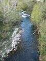 The Oasi Irminio area at 33 kilometres (21 mi) from the mouth.
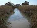 The Irminio near its mouth.
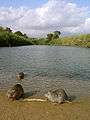 The Irminio at its mouth and some Coypu.
Notes
Coordinates: 36°54′19″N 14°44′30″E / 36.90528°N 14.74167°E