Interstate 95 in South Carolina
| ||||
|---|---|---|---|---|
_map.svg.png) | ||||
| Route information | ||||
| Maintained by SCDOT | ||||
| Length: | 198.8 mi[1] (319.9 km) | |||
| Existed: | 1968 – present | |||
| Major junctions | ||||
| South end: |
| |||
|
| ||||
| North end: |
| |||
| Location | ||||
| Counties: | Jasper, Hampton, Colleton, Orangeburg, Clarendon, Dorchester, Sumter, Florence, Darlington, Marlboro, Dillon | |||
| Highway system | ||||
| ||||
Interstate 95 is a major Interstate Highway, running along the East Coast of the United States from Florida to Maine. In South Carolina, I-95 runs approximately parallel to the Atlantic Ocean shore although about 50 miles (80 km) inland, from Hardeeville in the south to Dillon in the northeast. The route runs through the major cities of Florence and Walterboro.
Route description
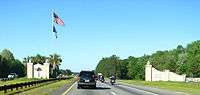
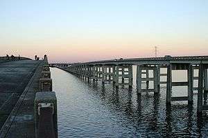
For the most part, the 198-mile (319 km) drive is fairly benign, passing through the pine forests, farmlands, and blackwater streams and swamps of the Coastal Plain. However, a few landmarks do exist to break up the monotony. Crossing from the south from Georgia just over the Savannah River bridge, motorists are greeted to an elaborate gateway into the state of South Carolina. The Juanita M. White Crosswalk also exists between exits 18 and 21.[2] A flyover on twin high-spans over Lake Marion provides an unexpected scenic break in the center of the highway's length. Moving further north and out of the Palmetto State, the NC state line is prominently marked by the South Of The Border amusement complex at the US 301/501 exit. Local traffic parallel to the interstate uses US 301 from South Of The Border to Santee, US 15 from Santee to Walterboro, and a combination of US 17 and US 17 Alt from Walterboro to the Georgia state line north of Savannah. In addition, Interstate 95 shares a number of concurrencies, or multiplexes, with three of these U.S. Routes at various stretches in South Carolina.
The old US 15-301 bridge runs along the west side of I-95 and is used for recreational purposes.
Services
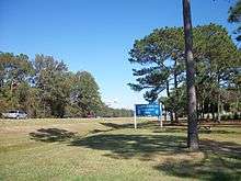
The South Carolina Department of Transportation (SCDOT) operate and maintain three welcome centers and five rest areas along I-95. Welcome centers, which have a travel information facility on site, are located at mile markers 4 (northbound), 99 (southbound) and 195 (southbound); rest areas are located at mile markers 47 (north and southbound), 99 (northbound) and 139 (north and southbound). Common at all locations are public restrooms, public telephones, vending machines, picnic area and barbecue grills.[3]
The South Carolina Department of Public Safety (SCDPS) and State Transport Police (STP) operate and maintain one truck inspection/weigh station, located northbound at mile marker 74. The location utilizes weigh-in-motion that does not require commercial motor vehicles to leave the freeway to be weighed. An inspection shed and pit are also on site, where full-service inspections are performed for flagged and randomly picked trucks.[4]
Several parking area locations are also found along I-95; these were either formally rest areas or weigh stations that were converted. The parking areas offer no amenities and some are even restricted for commercial motor vehicles only.
Dedicated and memorial names
Interstate 95 in South Carolina feature numerous dedicated or memorialized bridges, interchanges and stretches of freeway.
- Blue Star Memorial Highway – Official South Carolina honorary name of Interstate 95 throughout the state. Markers are located at both welcome centers.[5]
- Jacob Ham, Jr. Highway – Is a dedicated 2-mile (3.2 km) portion of Interstate 95 located in Darlington County, north of Florence. Dedicated in October, 2013, it is in honor of Lance Corporal Jacob Ham, Jr., who served as a trooper with the South Carolina Highway Patrol for 12 years until his death in 1998.[6][7][8]
- Mark H. Coates Highway – Is a dedicated 1-mile (1.6 km) portion of Interstate 95 located in Jasper County near Hardeeville and extends one-half mile on both sides of mile marker 7. In May 1997, the South Carolina General Assembly passed a resolution to designate this section of Interstate 95 in honor of Lance Corporal Mark Hunter Coates, who served as a trooper with the South Carolina Highway Patrol from 1987 until his death in 1992.[9] Coates, who was a native of Lexington County, South Carolina was fatally shot on mile marker 7 on November 20, 1992 during the course of a traffic stop.[10][11]
History
Interstate 95 first appeared on state maps between 1962-1964, with construction from US 17 north of Hardeeville to Ridgeland. By 1967, more sections were under construction, including Pocotaligo to Walterboro and Santee to the North Carolina state line. The first section to officially open happened in 1968, from SC 527, near Gable, to SC 9/SC 57, in Dillon.
In 1971-1972, more sections of Interstate 95 was completed: Going north from SC 9/SC 57, in Dillon, to the North Carolina state line. Going south from SC 527, near Gable, along the recently completed 1968-built Lake Marion bridge, to US 301 Connector, in Santee (exit 97).[12] Also part of US 17 between Ridgeland (exit 22) to near Yemassee (exit 33) was combined with Interstate 95, with temporary status through Coosawhatchie; Interstate 95 then continued on new freeway north to SC 63, in Walterboro.
By 1975, Interstate 95 was open continuously from US 17, in Hardeeville, to SC 63, in Walterboro; temporary exits were removed around Coosawhatchie. In 1976, the two sections of Interstate 95 were connected, from SC 63, in Walterboro, to US 301 Connector, in Santee (exit 97). In same year, exit numbers were added along Interstate 95. The last section of Interstate 95 was completed in 1978, connecting US 17, in Hardeeville, south to the Georgia state line.
In 1990, exit 21 was added, for what was then US 278, now SC 336. Between 1998-2000, exit 153, Honda Way, was added. In 2003, Interstate 95 was widened to six lanes from just south of Interstate 20 to north of SC 327, around Florence.[13]
Future
Various small projects along the route are scheduled to fix various intersections and replace bridges along route, but no major projects scheduled. Discussions of possibly converting Interstate 95 into a toll road have met with resistance, especially within SCDOT; however if both North Carolina and Georgia changed Interstate 95 into a toll road, then they would consider it as well.[14]
Local leaders in Hardeeville are pushing for a new exit 3, at Purrysburg Road, for a proposed RiverPort Business Park. Project is currently still in the planning stage with no time frame or official confirmation from SCDOT at this time.[15][16]
Additionally, community planners in Walterboro have been hinting at the desire for an I-95 business loop between Exits 53 and 57, along SC 63, US ALT 17, US 15, and SC 64.[17]
Exit list
| County | Location | mi[1] | km | Exit | Destinations | Notes | ||
|---|---|---|---|---|---|---|---|---|
| Jasper | State line | 0.0 | 0.0 | Crosses over the Savannah River; continuation into Georgia | ||||
| Hardeeville | 5.1 | 8.2 | 5 | |||||
| 8.2 | 13.2 | 8 | ||||||
| | 18.0 | 29.0 | 18 | Bees Creek Road – Switzerland | ||||
| Ridgeland | 20.8 | 33.5 | 21 | |||||
| 22.4 | 36.0 | 22 | South end of US 17 overlap | |||||
| | 28.3 | 45.5 | 28 | |||||
| Point South | 33.0 | 53.1 | 33 | North end of US 17 overlap | ||||
| Hampton | Yemassee | 38.2 | 61.5 | 38 | ||||
| Colleton | | 42.4 | 68.2 | 42 | ||||
| Walterboro | 53.6 | 86.3 | 53 | To Tuskegee Airmen Monument | ||||
| 57.5 | 92.5 | 57 | ||||||
| | 62.6 | 100.7 | 62 | Road 34 | ||||
| | 68.4 | 110.1 | 68 | |||||
| Dorchester | Edisto River | 68.8 | 110.7 | Bridge over Edisto River | ||||
| St. George | 76.7 | 123.4 | 77 | |||||
| | 82.3 | 132.4 | 82 | |||||
| Orangeburg | | 85.8 | 138.1 | 86 | Signed as exits 86A (east) and 86B (west); cloverleaf interchange | |||
| | 90.5 | 145.6 | 90 | |||||
| | 93.0 | 149.7 | 93 | |||||
| | 96.9 | 155.9 | 97 | South end of US 15 and US 301 overlap | ||||
| Santee | 98.3 | 158.2 | 98 | To Santee State Park | ||||
| Clarendon | Lake Marion | 99.8 | 160.6 | Bridge over Santee River/Lake Marion | ||||
| | 102.0 | 164.2 | 102 | North end of US 15 and US 301 overlap | ||||
| Summerton | 108.2 | 174.1 | 108 | Road 102 – Summerton | ||||
| | 114.7 | 184.6 | 115 | |||||
| | 119.0 | 191.5 | 119 | |||||
| | 122.1 | 196.5 | 122 | |||||
| | 132.4 | 213.1 | 132 | |||||
| Sumter | | 135.5 | 218.1 | 135 | To Myrtle Beach VIA Conway | |||
| | 141.1 | 227.1 | 141 | To Woods Bay State Natural Area | ||||
| | 145.9 | 234.8 | 146 | |||||
| Florence | | 149.9 | 241.2 | 150 | ||||
| | 153.7 | 247.4 | 153 | Honda Way – Timmonsville | ||||
| Florence | 157.5 | 253.5 | 157 | |||||
| 160.7 | 258.6 | 160 | Signed as exits 160A (east) and 160B (west) | |||||
| | 164.4 | 264.6 | 164 | |||||
| Darlington |
No major junctions | |||||||
| Florence | | 169.0 | 272.0 | 169 | TV Road – Quinby, Florence | |||
| | 170.7 | 274.7 | 170 | To Francis Marion University and Florence Airport | ||||
| Pee Dee River | 175.2 | 282.0 | Bridge over Pee Dee River | |||||
| Marlboro |
No major junctions | |||||||
| Dillon | | 181.7 | 292.4 | 181 | Signed as exits 181A (east) and 181B (west) | |||
| | Proposed interchange[18][19] | |||||||
| | 190.5 | 306.6 | 190 | |||||
| Dillon | 193.3 | 311.1 | 193 | Ben Bernanke exit ramp[20] | ||||
| State line | 198.8 | 319.9 | 1 | North Carolina exit 1 at state line | ||||
| 198.8 | 319.9 | Continuation into North Carolina | ||||||
1.000 mi = 1.609 km; 1.000 km = 0.621 mi
| ||||||||
See also
 South Carolina portal
 U.S. Roads portal
- Edisto River
- Lake Marion
- Pee Dee River
- South of the Border
References
- 1 2 Google (April 7, 2013). "Interstate 95 in South Carolina" (Map). Google Maps. Google. Retrieved April 7, 2013.
- ↑ South Caroline General Assembly 1993-1994(Bill #1355)
- ↑ "SC Rest Areas Map". South Carolina Department of Transportation. Retrieved December 29, 2014.
- ↑ "Weigh station opens on Interstate 95; first of kind in Southeast" (Press release). South Carolina Department of Public Safety. February 24, 2012. Retrieved December 29, 2014.
- ↑ "South Carolina Garden Club - Blue Star Memorial Program". Retrieved November 10, 2013.
- ↑ "Road dedicated to SC Highway Patrolman". Associated Press. Florence, SC: CarolinaLive.com. October 14, 2013. Retrieved November 10, 2013.
- ↑ "Lance Corporal Jacob Ham, Jr.". Retrieved November 10, 2013.
- ↑ "Lance Corporal Jacob Ham, Jr., South Carolina Highway Patrol, South Carolina". Retrieved November 10, 2013.
- ↑ Bill 4102, South Carolina General Assembly, 112th Session, 1997-1998, May 8, 1997
- ↑ "Lance Corporal Mark Hunter Coates". Retrieved November 10, 2013.
- ↑ "Trooper Mark Hunter Coates, South Carolina Highway Patrol, South Carolina". Retrieved November 10, 2013.
- ↑ "I-95 Lake Marion Bridge (Clarendon County, 1968)". Retrieved April 7, 2013.
- ↑ "Mapmikey's South Carolina Highways Page: Interstate 95". Retrieved April 7, 2013.
- ↑ Smith, Tim (February 12, 2012). "Tolls on I-95 creeping closer to South Carolina drivers". GreenvilleOnline.com. Greenville, SC. Retrieved February 12, 2012.
- ↑ Ports Panel Backs Interstate Exit (Hardeeville Today; Riverport, South Carolina)
- ↑ Saunders, Gwyneth (March 17, 2012). "Exit 3 plan important to future of Hardeeville". Savannah Morning News. Savannah, GA. Retrieved February 7, 2013.
- ↑ City of Walterboro – I-95 Business Loop Streetscape Corridor
- ↑ Staff. "Project Status: Northern Project". I-73 Environmental Impact Study. South Carolina Department of Transportation. Retrieved February 7, 2013.
- ↑ I-73 Northern Map (PDF) (Map). South Carolina Department of Transportation. Latta inset. Retrieved February 7, 2013.
- ↑ "Next exit: The Bernanke interchange". CNN. Retrieved October 23, 2015.
External links
 Media related to Interstate 95 in South Carolina at Wikimedia Commons
- Interstate 95 South Carolina (SouthEastRoads.com/AARoads.com)
- South Caroline General Assembly 1993-1994 (Bill #1355)
- Exitlists.com (I-95)
| Previous state: Georgia |
South Carolina | Next state: North Carolina |
| ||