Interstate 86 (Idaho)
| ||||
|---|---|---|---|---|
 | ||||
| Route information | ||||
| Maintained by ITD | ||||
| Length: | 62.850 mi[1] (101.147 km) | |||
| Major junctions | ||||
| West end: |
| |||
|
| ||||
| East end: |
| |||
| Highway system | ||||
| ||||

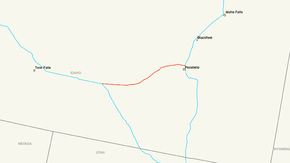
Interstate 86 (I-86) is an intrastate Interstate Highway, located entirely within the state of Idaho. It runs 63 miles (101.4 kilometers) from an intersection with Interstate 84 located approximately 7 miles (11.3 kilometers) east of Declo in rural Cassia County, to an intersection with Interstate 15 at Pocatello. Interstate 86 connects the major eastern Idaho cities of Pocatello and Idaho Falls with the Twin Falls area and other cities in the state's Magic Valley region. Prior to the designation of Interstate 2 on May 30, 2013, Interstate 86 in Idaho was the shortest east-west route in the Interstate Highway System which is not a special route.[2]
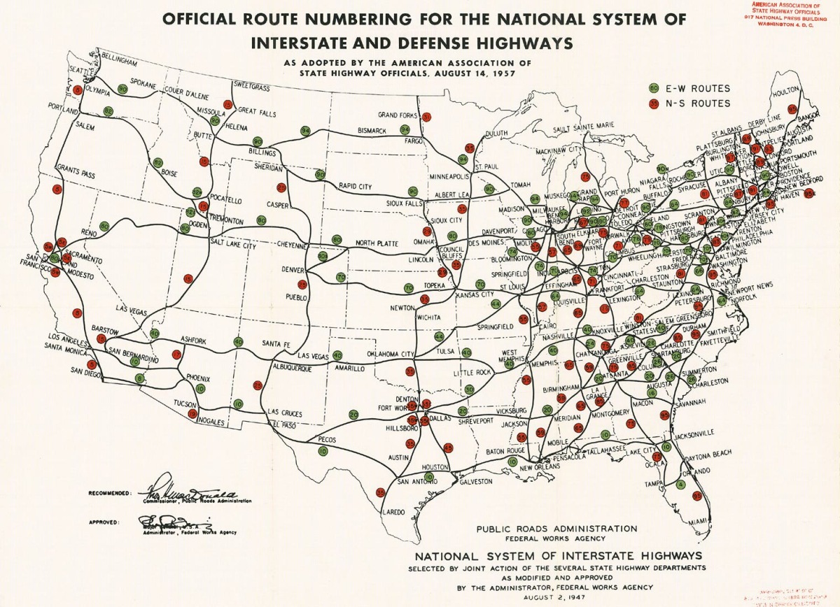
I-86 was proposed to become designated as Interstate 82N, but was eventually designated as Interstate 15W, instead.
Besides being short, the area Interstate 86 passes through is very desolate. Pocatello, Chubbuck and American Falls are the only incorporated settlements located on the highway. Between American Falls and Pocatello I-86 passes through a portion of Fort Hall Indian Reservation.
Route description

Cassia County
Running east, I-86 begins at an interchange with Interstate 84 and U.S. Route 30 in rural Cassia County; it becomes concurrent with US 30 at this interchange, and remains so for much of its route. The highway runs east through a rural and largely undeveloped section of Cassia County; it has no exits in its first 14 miles. After this section, I-86 crosses the Raft River and reaches an exit with Yale Road in the community of Raft River.
Power County
The highway continues east into Power County, running to the south of the Snake River. It reaches its next exit, at Barkdull Road in Coldwater, around milepost 21. I-86 heads northeast along the river to an exit at Massacre Rocks State Park. The highway continues northeast to meet Rock Creek Road in Neeley. Past Neeley, I-86 reaches an interchange with Idaho State Highway 37, which runs south to Rockland, and Interstate 86 Business, a business loop serving American Falls.
I-86 bypasses American Falls to the southeast, meeting its business loop and Idaho State Highway 39 east of the city near American Falls Airport. The highway runs south of the American Falls Reservoir to its next exit at Ramsey Road near Seagull Bay. Past this exit, the route enters the Fort Hall Indian Reservation. After passing another exit at Rainbow Road near the eastern edge of the reservoir, I-86 heads eastward toward Pocatello. It serves exits at Arbon Valley and the Pocatello Air Terminal before leaving the Fort Hall Indian Reservation. US 30 leaves I-86 at the next exit to the southeast, where the latter continues eastward across the Portneuf River.
Bannock County
The highway crosses into Bannock County and enters the city of Chubbuck, where it intersects U.S. Route 91. I-86 briefly passes through Pocatello without an interchange in the city and terminates at Interstate 15 outside the Pocatello city limits.[1][3]
History
The route of Interstate 86 largely derives from a portion of U.S. Route 30N constructed in the 1920s, which in Idaho originally ran from Burley to a point on the Wyoming state line near Montpelier. Present-day Interstate 86 was proposed to become part of the Interstate Highway System as Interstate 82N,[4] but was eventually designated in 1960 as Interstate 15W.[5] U.S. Route 30N was designated as part of U.S. Route 30 in 1972. Interstate 86 continues to run concurrently with U.S. Route 30 for almost its entire length.[6]
In the late 1970s, the American Association of State Highway and Transportation Officials decided it was better to have duplicate numbers in different parts of the country instead of having suffixes. There was also an Interstate 15E in California at the time. Interstate 15W was re-designated as Interstate 86 in 1980.[7]
Exit list
| County | Location | mi[1] | km | Exit | Destinations | Notes |
|---|---|---|---|---|---|---|
| Cassia | Declo | 0.000 | 0.000 | West end of US-30 overlap | ||
| 0.000 | 0.000 | 1 | Westbound exit and eastbound entrance, western terminus; I-84 exit 222 | |||
| | 14.807 | 23.830 | 15 | Raft River Area | ||
| Power | | 20.590 | 33.136 | 21 | Coldwater Area | |
| | 28.100 | 45.223 | 28 | Massacre Rocks State Park | ||
| | 32.620 | 52.497 | 33 | Neeley Area | ||
| American Falls | 36.123 | 58.134 | 36 | West end of Business Loop 86 | ||
| 40.110 | 64.551 | 40 | East end of Business Loop 86 | |||
| | 44.327 | 71.337 | 44 | Seagull Bay | ||
| | 49.152 | 79.102 | 49 | Rainbow Road | ||
| | 52.491 | 84.476 | 52 | Arbon Valley | ||
| | 55.551 | 89.401 | 56 | Pocatello Air Terminal | ||
| | 58.087 | 93.482 | 58 | East end of US-30 overlap | ||
| Bannock | Chubbuck | 61.268 | 98.601 | 61 | ||
| 62.526 | 100.626 | 63 | Eastern terminus and signed as exits 63A (south) and 63B (north); I-15 exit 72 | |||
1.000 mi = 1.609 km; 1.000 km = 0.621 mi
| ||||||
References
- 1 2 3 "Interstate 86 Milepoint Log". Idaho Transportation Department. Retrieved 28 February 2011.
- ↑ Idaho Transportation Department (accessed 3 January 2012)
- ↑ "Overview map of Interstate 86". Google Maps. Google, Inc. Retrieved 28 February 2011.
- ↑ Official Route Numbering for the National System of Interstate and Defense Highways (JPG) (Map). American Association of State Highway and Transportation Officials. August 14, 1957. Retrieved May 4, 2014.
- ↑ Idaho Highways (accessed 3 January 2012)
- ↑ U S Roads --- Idaho (accessed 3 January 2012)
- ↑ Idaho Highways (accessed 3 January 2012)
External links
| Wikimedia Commons has media related to Interstate 86 (Idaho). |
- Idaho Highway Index Page (photos of I-86)
| Signed | |||||||||||
|---|---|---|---|---|---|---|---|---|---|---|---|
| Unsigned | |||||||||||
| Lists |
| ||||||||||
Major Interstates highlighted | |||||||||||