Interstate 84 in New York
| ||||
|---|---|---|---|---|
|
Map of New York with I-84 highlighted in red | ||||
| Route information | ||||
|
Maintained by NYSDOT and NYSBA NYSTA (1991-2010) | ||||
| Length: | 71.46 mi[1] (115.00 km) | |||
| Existed: | 1963[2] – present | |||
| Major junctions | ||||
| West end: |
| |||
|
| ||||
| East end: |
| |||
| Location | ||||
| Counties: | Orange, Dutchess, Putnam | |||
| Highway system | ||||
| ||||

_map.svg.png)
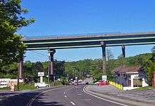
Interstate 84 (I-84) is a part of the Interstate Highway System that runs from Dunmore, Pennsylvania, to Sturbridge, Massachusetts, in the Eastern United States. In New York, I-84 extends 71.46 miles (115.00 km) from the Pennsylvania state line at Port Jervis to the Connecticut state line east of Brewster. As it heads east–west across the mid Hudson Valley, it goes over two mountain ranges and crosses the Hudson River at the Newburgh–Beacon Bridge.
It is the only limited-access road to cross New York from west to east between New York City and the Capital District. As such it is the main vehicular route between Southern New England and Pennsylvania and points west. It is maintained by the New York State Department of Transportation (NYSDOT), which recently resumed full control after two decades in which routine maintenance was performed by the New York State Thruway Authority under yearly contract from DOT. The New York State Bridge Authority charges eastbound traffic a $1.50 toll for cars to maintain the Newburgh–Beacon Bridge.
Construction of the highway began later than other interstates in New York as legal hurdles to the construction of the bridge had to be removed, and federal funding was more limited when it finally began in 1960. It was completed 12 years later, becoming a major commercial artery and mainstay of the Hudson Valley economy and offering travelers a view of some of the state's scenic areas in the Shawangunks and Hudson Highlands.
Route description
I-84 passes through three counties. The entire stretch between the Delaware and Hudson, more than half the road's total length in New York, is in Orange County. East of the river the road begins in Dutchess County and then drops southward into Putnam County.
Two other highways parallel the interstate for some length. U.S. Route 6 (US 6) follows it closely near the state lines, but takes a southerly course between those two areas. New York State Route 52 (NY 52) joins I-84 from Newburgh to Fishkill and remains parallel from there to Lake Carmel.
West of Hudson (Orange County)
I-84 enters New York near Port Jervis via a long bridge that crosses both the Delaware and Neversink rivers just above their confluence. This bridge is owned and maintained by the NYSDOT, including the portion in Pennsylvania. Fifty feet (15 m) south of the road is Tristate Rock, where New Jersey, New York and Pennsylvania converge. For its first mile in New York, the interstate is immediately north of the New Jersey state line in the city of Port Jervis. The first exit is signed for US 6 and New Jersey Route 23, which begins just south of the exit with many gas stations allowing motorists to take advantage of lower fuel taxes in New Jersey.[3]

Route 6 remains parallel to the north of the freeway as I-84 begins an immediate climb away from the state line up the Shawangunk Ridge, beginning an east-northeast slant in its direction that will continue for almost 30 miles (48 km). The roadway crests at 1,275 feet (389 m), its highest elevation in New York. Scenic overlooks on either side allow travelers to stop and take in the expansive view of Port Jervis, the lower Neversink valley and adjacent regions of Pennsylvania. On the descent, Route 6 crosses under the interstate again, reachable by a short drive south on Mountain Road at exit 2.
East of the Shawangunks it is 13 miles (21 km) to the next exit. The freeway winds through swamps from which the obelisk atop High Point, New Jersey's highest mountain, is visible. These give way to wooded areas eventually broken by fields in the Town of Wawayanda where Route 6 crosses over again to merge with NY 17M and recross at exit 3, the first of two that serve the city of Middletown. A mile and a half (2.4 km) further east along that roadway is the Middletown rest area, with restrooms and a state police substation. The other Middletown exit serves NY 17, the long freeway slowly being transformed into I-86, another mile further to the east.

This junction is the western corner of Orange County's "Golden Triangle" of interstates, so named for its attractiveness to businesses for their distribution centers.[4][5] Immediately afterward I-84 passes between the Galleria at Crystal Run, the county's largest mall, and the eponymous office park to the south. More farms begin to break up the landscape off the road. Westbound traffic is served by the Wallkill rest area four miles (6 km) east of Route 17. The tracks of Metro-North Railroad's Port Jervis Line runs just north of the highway for a short distance, and NY 211 also parallels for several miles past the hills of Highland Lakes State Park.
After crossing the Wallkill River and NY 416, I-84 climbs slightly to its first exit in almost 10 miles (16 km), NY 208, serving nearby Walden and Maybrook. Heavy truck traffic at this exit reflects a nearby truck stop,[6] Yellow Freight's large presence in Maybrook[7] and a Staples warehouse[8] north of the interstate along 208. The highway continues, now almost due east, of this exit through more wooded area, forming the northern border of Stewart State Forest, for four miles (6.4 km) to the recently built exit with NY 747 intended to improve access to nearby Stewart International Airport.
A mile beyond, the road reaches the first of four exits serving Newburgh, the largest community along it in New York. It veers slightly to the north again after the interchange with NY 17K, which has been running parallel to the north since Route 208. Another truck stop[9] is located off this exit, with a major FedEx[10] and the U.S. Postal Service's Mid-Hudson General Mail Facility[11] in the industrial park between the interstate and the airport.
The freeway resumes its eastern heading again and descends a gentle slope to its junction with the New York State Thruway (I-87) and NY 300. Traffic was routed to the Thruway via a short section of 300 when the interstate was built, but a major project to build a connector directly to the toll road was completed in December 2009, after being under construction for five years.[12][13][14]
After passing though a rock cut, I-84 levels off and begins following the northern border of the city of Newburgh, where first NY 52 joins it, beginning the only concurrency with the interstate in the state. A mile and a half (2 km) east, US 9W and NY 32 provide the last exit before the road crosses the Newburgh–Beacon Bridge, with views of Newburgh Bay and the Hudson Highlands to the south.
East of Hudson (Dutchess and Putnam counties)
The bridge also crosses Metro-North's Hudson Line tracks on the east side of the river. The NY 9D exit after the toll plaza is the first of two serving the city of Beacon, just to the south of the freeway. It then curves slightly to the north, passing Dutchess Stadium, home of the Hudson Valley Renegades, to the north and then the large open area between Downstate and Fishkill state prisons, where signs warn motorists not to stop. To the south a panoramic view from Beacon to Schunemunk mountains is available.

The road resumes its eastern heading and descends slightly to the next exit, where Route 52 leaves the freeway for the village of Fishkill. I-84 bends through the lowlands north of Sour Mountain, northern end of the Hudson Highlands, and crosses Fishkill Creek. Just north of the historic Van Wyck Homestead, and south of a large Old Navy regional distribution center,[15] it intersects US 9, which becomes a divided highway from north of the exit to Poughkeepsie.
It begins to climb into the hills east of this exit, passing through some rock cuts in the four miles (6 km) to the Lime Kiln Road exit, which allows easy access to a nearby former IBM facility now known as Hudson Valley Research Park.[16] From there it descends gently over two miles (3 km), with Hosner Mountain looming to the east, to the sprawling interchange with the Taconic State Parkway. It ascends again afterwards, passing scenic overlooks on either side that allow views of the valley and the Catskills to the northwest. At the crest, near where the Appalachian Trail crosses over, signs indicate the road has once again reached 1,000 feet (305 m) in elevation.
I-84 begins to veer to the south at this point, and soon it descends through some rock cuts to cross into Putnam County just before the Ludingtonville Road exit, with NY 52 a short distance to the south. The road heads in a more south-southeast direction the next 10 miles (16 km). The NY 311 exit offers the last connection to Route 52, a short distance to the south over Lake Carmel, and after crossing Metro-North's Harlem Line the interchange with NY 312 offers access to the large strip mall on a hill southeast of the exit and the Southeast train station.
After a quarter-mile long (400 m) bridge over the Croton River, US 6, US 202 and NY 22 just north of Brewster, the interstate returns to its eastern heading for the northern terminus of I-684, an exit that also provides access to the other three highways. For eastbound travelers this is the last exit in New York.
Routes 6 and 202 closely parallel I-84 to the north, between the freeway and one of the upper basins of East Branch Reservoir, part of New York City's water supply system. The northern terminus of NY 121 lets eastbound traffic on and westbound traffic off. Two miles (3.2 km) to the east, Signs appear for Saw Mill Road, exit 1 on Connecticut's stretch of I-84, and its ramps leave the highway just a hundred feet (30 m) before the state line.
History
1950s: Proposal and design
The route of I-84 through the state began in the late 1940s, when the then-New York State Department of Public Works, now NYSDOT, was planning Governor Thomas Dewey's proposed Thruway system. The plan was for the Thruway's main line to cross the river between Newburgh and Beacon, an area then in the middle of a 30-mile (48 km) gap in fixed river crossings. The remainder of the expressway would be toll-free.[2]
Politicians in the Newburgh area had also been lobbying for a bridge over Newburgh Bay, as the ferry service in that section of the river was becoming financially unviable. In 1951 they were able to authorize test borings in the riverbed to see if a bridge was feasible. It was, but their counterparts further up the river got legislation passed that prohibited any construction of the Newburgh Bay bridge until the Kingston–Rhinecliff Bridge was completed.
By the early 1950s the road plan had changed. The Thruway had been rerouted to cross the Hudson at the present site of the Tappan Zee Bridge. Dewey suggested that I-84 be built as a separate toll road instead. After the passage of the Federal Aid Highway Act of 1956, during the Averell Harriman administration, state officials changed it back to a free road in order to get federal funding for the project. It remained on paper as other New York interstates got underway.[2]
Assemblyman Lee Mailler of Cornwall, that body's majority leader, was able to get the bridge construction prohibition repealed in 1954. A bond issue the next year made the first money available for the construction of both the Kingston and Newburgh bridges. In 1959, it looked it would be delayed again when the federal funding formula was changed and less money was available, making a four-lane bridge too expensive to construct.[17]
1960s–70s: Construction and expansion
Construction began in 1960 after the new governor, Nelson Rockefeller, promised to expedite it during his campaign by building a single span, within the limits of what the state could afford without federal aid. The new plans called at first for a freeway connection for I-87 from Beacon to the Bronx and a concurrency across the river. After that project was cancelled after heavy local opposition. I-87 was routed to join I-84 at Brewster (where it would have followed the route of the current I-684). The first segment, the 16 miles (26 km) between the Thruway mainline in the Town of Newburgh and US 9 in Fishkill, was opened November 2, 1963.[2] The Newburgh–Beacon Bridge crossed nearly two miles of Newburgh Bay and led to the last run of the original Newburgh–Beacon Ferry the day after it opened.[17]
The following year the eastern terminus of the new interstate was extended to the Taconic State Parkway. The rest of the route would be slowed by both the hilly terrain and local resistance over what was felt to be inadequate eminent domain payments to affected landowners. In 1970 the road was complete to NY 311, with the former route of I-87 redesignated as I-684, and no concurrency along the interstate save the seven miles (11 km) shared with NY 52. A year later, all the mileage east of the river was open. The last segment finished was the one between NY 208 and the Thruway.[2][18]

With I-84 complete soon after from Scranton to Hartford, the heavy traffic created traffic jams at the bottlenecks at either end of the bridge. In 1975 a second span was approved. It was opened on November 1, 1980, almost 17 years to the day traffic first crossed the original span. Two lanes could still not handle all the traffic, and four years later, in 1984, the bridges were reconfigured to their present three-lane configuration.[2][18]
Effect on western Orange County state highways
The highway's route number prompted the renumbering of several existing state routes in western Orange County, where there was already an NY 84. To avoid confusion, the NY 84 designation was eliminated and replaced with other routes in the mid-1960s. The portion south of US 6 at Slate Hill became NY 284 while the section of NY 84 north from Middletown to its northern terminus at NY 17K in Montgomery was added to NY 211, which had previously terminated at its junction with NY 17M and NY 84 in Middletown. The rest of NY 84 remained part of US 6 and NY 17M, which NY 84 had overlapped through Middletown.[19][20] Lastly, NY 416 was truncated to its current northern terminus just south of Montgomery rather than ending at 17K as it had before. In addition, New Jersey renumbered Route 84 to Route 284 to match New York renumbering NY 84 to NY 284.[21]
1990s–2000s: Thruway Authority and interchange work

In 1991, with New York facing a large budget deficit, Mario Cuomo's administration decided that the state DOT would essentially sell I-84 and the Cross-Westchester Expressway (I-287), to the cash-rich New York State Thruway Authority (NYSTA) as one way of closing it. No tolls could be charged since the roads were built with federal money, and DOT remained in charge of large capital projects, but the Thruway took over routine maintenance. During this time two interchanges were expanded and a new one created. The authority had the option of, at any time, returning the road to the state's control at a year's notice.[22]
The first was the US 9 exit, revamped in 1999 at a cost of $25 million.[15] I-84 was widened in both directions approaching the exit, a second overpass was added and the exit ramps were widened and signage improved. Around that time the two agencies also announced plans, and received federal funding, for a redone exit 7 that would allow traffic to go directly between I-84 and the Thruway instead of using a short stretch of NY 300, which by then was more heavily developed than it had been when the interstates were first built. The three-phase construction project was initialized in May 2003[23] and completed in December 2009.[24]
The new exit 7 also replaces 13 old buildings with a few new ones: a separate toll plaza to handle traffic entering the Thruway (the existing toll plaza will be dedicated to exiting traffic), offices and garages for NYSTA and the state police. The new buildings will use green techniques to minimize energy use such daylighting and rainwater collection. The ramps have been rerouted, using six new bridges and five new miles (8 km) of roadway, so that almost all traffic from routes 17K and 300 now use the latter route to access both interstates. The existing connector from the toll plaza to Route 17K will remain as an E-ZPass–only lane from that highway to the northbound Thruway.[25]

After lengthy litigation by environmental groups concerned about the impact on nearby Stewart State Forest, in 2005 construction began on exit 5A. Local road Drury Lane was upgraded and widened into newly designated NY 747 to allow easier access to Stewart International Airport via an almost-full diamond interchange. It was completed in November 2007, at the same time the briefly privatized airport was turned over to the Port Authority of New York and New Jersey with the intent of making it the New York City metropolitan area's fourth major airport.
The Thruway Authority's involvement with the road would have ended in 2006 when its board voted to transfer the highway back to the state DOT, a move it suggested did not commit it to doing so. The proceeds would have covered NYSTA's expenses in eliminating the toll barrier for a year on I-190 south of Buffalo.[26]
This was seen as an election-year move to help Republican candidates in Western New York. But residents of the mid-Hudson region felt NYSTA had done a better job plowing the road in winter, and Thruway workers assigned to I-84 feared having to move or working for the DOT at lower pay and with different union representation.[22]
State Senator John Bonacic, a member of that body's then-Republican majority whose district covers western Orange County, introduced legislation at the beginning of 2007 to block the changeover. He succeeded, as the budget lawmakers and new governor Eliot Spitzer agreed to appropriate enough money for DOT to continue paying the Thruway Authority for snow removal, litter pickup and mowing along the entire highway save the bridge.[22] The DOT picked up the cost of having state police Troop T, which patrols the Thruway, continue to cover I-84. This agreement was renewed in 2008.[27]
In 2010, maintenance fully reverted to DOT. With the state facing financial difficulties in the slow economy, Governor David Paterson decided that DOT could save a few million dollars doing the work itself. In August of that year, the department bought $6 million worth of new equipment and hired 54 new employees to handle maintenance duties on the highway.[28]
In October, Thruway insignia and signs indicating its maintenance responsibilities were removed from the roadway, and authority employees assigned to the road began transferring to jobs elsewhere, after the union waived several contract provisions to smooth the transfer. State troopers who patrolled the road were reassigned from Thruway-based Troop T to troops F and K, which cover the west and east sides of the Hudson respectively. At the DOT's request, the two state police substations in Wallkill and East Fishkill remained open.[29]
Incidents

Many traffic accidents, some fatal, have caused traffic jams and closures since I-84 was opened. One was notable for the type of vehicle involved; another led to a still-open murder investigation.
On August 6, 1976, drivers along the road near exit 18 (NY 311) in the Putnam County town of Patterson saw a low-flying helicopter cross over the interstate and then get entangled in the power lines passing overhead. The craft flipped over and fell onto the eastbound lanes of the highway. Both pilot and passenger were killed, and 4,000 customers in the area lost power. A traffic backup of several miles was rerouted onto the road's shoulder around the crash site until the road was reopened two and a half hours later.[18] The National Transportation Safety Board investigated and ruled the cause to be pilot error.[30]
A road rage incident on the side of the highway led to the death of Richard Aderson in 1997. Aderson, an assistant superintendent at the Valley Central School District in Montgomery, was returning to his LaGrange home on the evening of February 5, 1997, when he had a minor collision with a relatively new green Jeep Cherokee carrying what appeared to be New Hampshire license plates just before crossing the Newburgh–Beacon Bridge. The two drivers pulled over near exit 12, and after a brief argument the other driver shot Aderson and left the scene. Aderson was able to give the 9-1-1 operator he called on his cell phone a description of his assailant and the vehicle before dying at the scene. A police sketch based on Aderson's description has been widely circulated and is still posted prominently in kiosks at the freeway's rest areas. The case has been dramatized on both America's Most Wanted and Unsolved Mysteries, generating many leads since then but remains open.[31][32]
Exit list
| County | Location | mi[1] | km | Exit | Destinations | Notes |
|---|---|---|---|---|---|---|
| Orange | Deerpark | 0.00 | 0.00 | – | Continuation into Pennsylvania | |
| 0.66 | 1.06 | 1 | ||||
| Greenville | 4.76 | 7.66 | 2 | Mountain Road | ||
| Wawayanda | 15.44 | 24.85 | 3 | Signed as 3E (east) and 3W (west) | ||
| Wallkill | 19.10 | 30.74 | 4 | Signed as 4E (east) and 4W (west); exit 121 on NY 17 | ||
| Town of Montgomery | 28.78 | 46.32 | 5 | |||
| Town of Newburgh | 32.99 | 53.09 | 5A | Opened November 20, 2007[33] | ||
| 34.14 | 54.94 | 6 | ||||
| 36.54 | 58.81 | 7A | Exit 17 on I-87 / Thruway | |||
| 36.54 | 58.81 | 7B | ||||
| City of Newburgh | 37.44 | 60.25 | 8 | Western terminus of concurrency with NY 52 | ||
| 39.04 | 62.83 | 10 | Signed as 10S (US 9W south / NY 32) and 10N (US 9W north) westbound | |||
| Hudson River | Newburgh–Beacon Bridge (eastbound toll of $1.50) | |||||
| Dutchess | Beacon | 41.49 | 66.77 | 11 | ||
| Fishkill | 44.77 | 72.05 | 12 | Eastern terminus of concurrency with NY 52 | ||
| 46.24 | 74.42 | 13 | Signed as 13S (south) and 13N (north) westbound | |||
| East Fishkill | 50.44 | 81.18 | 15 | Lime Kiln Road (CR 27) | ||
| 52.64 | 84.72 | 16 | Signed as 16S (south) and 16N (north); future exit 37 (Taconic Parkway)[34] | |||
| Putnam | Kent | 58.84 | 94.69 | 17 | ||
| Patterson | 61.80 | 99.46 | 18 | |||
| Southeast | 65.44 | 105.32 | 19 | |||
| 68.30 | 109.92 | 20 | Signed as 20S (I-684) and 20N (US 6 / US 202 / NY 22) eastbound; exit 9 on I-684 | |||
| 69.26 | 111.46 | 21 | Westbound exit and eastbound entrance | |||
| 71.46 | 115.00 | – | Continuation into Connecticut | |||
1.000 mi = 1.609 km; 1.000 km = 0.621 mi
| ||||||
Exits 9 and 14
New York is one of the few remaining states that number exits sequentially rather than by mileage. Its stretch of I-84 omits exits 9 and 14, both of which were originally reserved for projects that were never built.
The state owned the land just west of the Gidney Avenue overpass, which would have been exit 9. In the 1970s the state had been forced to cancel its plans to create ALT US 9W, an expanded arterial road through the town and city of Newburgh. Community opposition and rising land costs both played a role; the land has since been sold, ending any chance of the project being revived. The arterial was instead constructed as a boulevard along the City of Newburgh waterfront; originally named Marine Drive, it is now Dr. Rev. Martin Luther King Boulevard.
Exit 14, to have been built west of the Route 9 interchange, would have been the northern end of I-487, the Hudson River Expressway project proposed along with the original routing of I-84.
See also
.svg.png) New York Roads portal
New York Roads portal
References
- 1 2 "Interchange Listing with Mileposts". New York State Thruway Authority. Retrieved January 27, 2010.
- 1 2 3 4 5 6 Anderson, Steve. "Interstate 84-New York Historic Overview". NYCRoads. Retrieved January 12, 2009.
- ↑ Mitra, Maureen (February 7, 2003). "N.Y. gas prices send many to N.J. to get their fill". Times Herald-Record. Middletown, NY. Retrieved January 16, 2009.
The combination of state taxes in New York is about 9 cents higher than in New Jersey.
- ↑ Doherty, John (December 13, 2005). "Drivers face risky ride on jam-packed I-84". Times Herald-Record. Middletown, NY. Retrieved January 16, 2009.
that stretch of I-84 – dubbed the Golden Triangle by traffic experts for its proximity to Route 17 and the New York Thruway
- ↑ Scott, Brendan (July 24, 2006). "Diana recycling Water Loop plan". Times Herald-Record. Middletown, NY. Retrieved January 16, 2009.
Then: Hoping to feed Orange County's growing thirst, County Executive Louis Heimbach lays plans for a huge circular water system, a 'water loop,' to link the 'Golden Triangle' framed by Route 17 and Interstates 84 and 87.
- ↑ "Maybrook, New York #210". TravelCenters of America. Retrieved January 17, 2009.
- ↑ "New York Terminals". Yellow Transportation. 1994–2009. Retrieved January 17, 2009.
- ↑ "Staples Purchases Multi-channel Fulfillment Center in Montgomery, New York; New Site Enables Staples to Better Serve Contract, Catalog and E-Commerce Customers" (Press release). Business Wire. September 28, 2000. Retrieved January 17, 2009.
- ↑ "#394 Newburgh, NY". Pilot Travel Centers. 2009. Retrieved January 22, 2009.
- ↑ "Location Details". FedEx. 1995–2009. Retrieved January 21, 2009.
- ↑ "Stewart International Airport". Town of New Windsor. 2008. Retrieved January 22, 2009.
... the U.S. Postal Service general mail facility is located at Stewart.
- ↑ Rife, Judy (July 14, 2009). "New I-87 ramp nearly done". Times Herald-Record. Middletown, NY. p. 31. Retrieved June 3, 2010.
- ↑ Rife, Judy (September 22, 2009). "I-84/87 interchange 90% done". Times Herald-Record. Middletown, NY. p. 28. Retrieved June 3, 2010.
- ↑ Fitzpatrick, Meghan (December 8, 2009). "Interchange Creates A True 'Crossroad'". The Sentinel. New Windsor, NY. p. 1.
- ↑ "Buildings and Sites". Dutchess County. February 23, 2006. Archived from the original on October 28, 2007. Retrieved April 22, 2012.
The facility is located on I-84, just 18 miles east of the New York State Thruway and only 90 minutes north of New York City
- 1 2 "New York State Bridge Authority Newburgh–Beacon Bridge Page". New York State Bridge Authority. Retrieved January 13, 2009.
- 1 2 3 "From Dirt Roads to the Interstate Highway". Town of Patterson. 2006–2009. Retrieved January 14, 2009.
- ↑ New York and Metropolitan New York (Map). Cartography by Rand McNally and Company. Sinclair Oil Corporation. 1964.
- ↑ New York (Map) (1969–70 ed.). Cartography by General Drafting. Esso. 1968.
- ↑ New Jersey (Map). Cartography by American Oil Company. American Oil Company. 1968.
- 1 2 3 Rife, Judy (March 31, 2007). "Bonacic wins war over I-84; Thruway Authority to remain in charge". Times Herald-Record. Middletown, NY. Retrieved January 14, 2009.
- ↑ "I-84/I-87 Interchange 17 Reconstruction Project". New York State Thruway Authority. December 7, 2009. Archived from the original on June 13, 2010. Retrieved April 22, 2012.
- ↑ "Thruway Authority Announces Completion of Project to Connect I-87 & I-84" (Press release). New York State Thruway Authority. December 7, 2009. Retrieved January 10, 2010.
- ↑ Rife, Judy (April 13, 2008). "I-84, Thruway soon to meet". Times Herald-Record. Middletown, NY. Retrieved January 14, 2009.
- ↑ Rife, Judy (October 30, 2006). "I-84 maintenance could be at stake". Times Herald-Record. Middletown, NY. Retrieved January 14, 2009.
- ↑ Rife, Judy (April 14, 2008). "Thruway Authority gets $10.3M to maintain I-84". Times Herald-Record. Middletown, NY. Retrieved January 14, 2009.
- ↑ Rife, Judy (August 24, 2010). "DOT prepares to resume Interstate 84 care". Times Herald-Record. Middletown, NY. Retrieved October 13, 2010.
- ↑ Rife, Judy (October 11, 2010). "DOT takes over maintenance on I-84". Times Herald-Record. Middletown, NY. Retrieved October 13, 2010.
- ↑ "NYC76AN120". National Transportation Safety Board. Retrieved January 22, 2009.
- ↑ Lynch, Elizabeth (February 4, 2002). "5 years after road rage killing on Interstate 84, mystery remains". Poughkeepsie Journal. Retrieved January 14, 2009.
- ↑ "Memorial to making a difference". Times Herald-Record. Middletown, NY. February 12, 2007. Retrieved January 14, 2009.
- ↑ Randall, Michael (November 20, 2007). "Drury Lane interchange opens in time for holidays". Times Herald-Record. Middletown, NY. Retrieved January 22, 2009.
A ceremony at 1:30 p.m. today will celebrate the official dedication and opening of the long-awaited Drury Lane interchange that will allow drivers to get from Interstate 84 to the airport more directly.
- ↑ Coyne, Matt (September 4, 2016). "Taconic State Parkway to get exit numbers". The Journal News. Retrieved September 6, 2016.
External links
| Wikimedia Commons has media related to Interstate 84 in New York. |
- Interstate 84 at Alps' Roads • New York Routes • Upstate New York Roads
- New York State Police page on the Richard Aderson shooting
| Previous state: Pennsylvania |
New York | Next state: Connecticut |