Interstate 76 (Ohio–New Jersey)
| ||||||||||
|---|---|---|---|---|---|---|---|---|---|---|
 | ||||||||||
| Route information | ||||||||||
| Length: | 434.87 mi[1] (699.86 km) | |||||||||
| Existed: | 1964[2] – present | |||||||||
| Major junctions | ||||||||||
| West end: |
| |||||||||
| ||||||||||
| East end: |
| |||||||||
| Location | ||||||||||
| States: | Ohio, Pennsylvania, New Jersey | |||||||||
| Highway system | ||||||||||
| ||||||||||

Interstate 76 (I-76) is an Interstate Highway in the United States, running 435 miles (700 km) from an interchange with Interstate 71 west of Akron, Ohio, east to Interstate 295 in Bellmawr, New Jersey.
Just west of Youngstown, I-76 joins the Ohio Turnpike and heads around the south side of Youngstown. In Pennsylvania, I-76 runs across most of the state on the Pennsylvania Turnpike, passing near Pittsburgh and Harrisburg before leaving the Turnpike to enter Philadelphia on the Schuylkill Expressway, crossing the Walt Whitman Bridge into New Jersey. After Interstate 76 reaches its eastern terminus, the freeway continues as Route 42 and the Atlantic City Expressway to Atlantic City.
Route description
| mi | km | |
|---|---|---|
| OH | 82.12 | 132.16 |
| PA | 349.67 | 562.74 |
| NJ | 3.08 | 4.96 |
| Total | 434.87 | 699.86 |
Ohio
Lodi to Youngstown
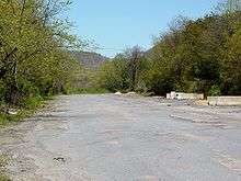
I-76 begins at Interstate 71 at exit 209, east of Lodi, Ohio; U.S. Route 224 continues west from the end of I-76. The interchange was previously a double trumpet, but was reconstructed in 2010.[3]) Officially, I-76 begins at the beginning of the ramp from I-71 north; it merges with US 224 at mile 0.61. After passing through rural Medina County, I-76 enters Summit County and soon crosses State Route 21 (old US 21), once the main north–south route through the area until Interstate 77 replaced it, at a cloverleaf interchange. I-76 then passes Barberton and enters Akron; this section of road was built as US 224.
Soon after entering Akron, I-76 exits the main freeway, which continues east as Interstate 277, onto the short Kenmore Expressway; U.S. Route 224 leaves I-76 there and continues east as a surface road after I-277 ends at Interstate 77. Shortly after heading north from the I-277 interchange, I-76 meets I-77 and again turns east, joining southbound I-77 through downtown Akron on the West Expressway. A partial interchange provides access to State Route 59, the Innerbelt, and then I-76 crosses through the Central Interchange, where I-77 goes south (on the South Expressway) and State Route 8 begins to the north (on the North Expressway); I-76 switches from the West Expressway to the East Expressway.

Leaving the Akron area, I-76 again heads through rural areas, crossing Portage County and entering Mahoning County. West of Youngstown, the freeway crosses the Ohio Turnpike. Officially I-76 transfers to the Turnpike at the overpass, with a similar change happening with Interstate 80 (east on the freeway to Youngstown and west on the Turnpike). In reality, access between the roads is via a double trumpet connection in the northeast corner of the crossing, along which I-76 traffic and I-80 traffic run in opposite directions.
Youngstown area and east
The Ohio Turnpike carries I-76 starting from around Youngstown, Ohio until the Pennsylvania border.
Pennsylvania
Pennsylvania Turnpike

From the Ohio border, the Pennsylvania Turnpike carries I-76 into and across most of Pennsylvania, bypassing Youngstown to the south and Pittsburgh to the north. From the Ohio border until Warrendale, the turnpike uses a non-ticketing toll system while east of Warrendale, the ticketing system begins. There is a free interchange with U.S. 19 and I-79 near Wexford. At one point, I-76 used to be routed through Pittsburgh on a route that is now signed as Interstate 376, around the 1970s.

From New Stanton to Breezewood, I-76 is concurrent with I-70. In this section are the bypass (built in the 1960s) of the Laurel Hill Tunnel, then the still-in-use Allegheny Mountain Tunnel in a relatively unpopulated section of south central Pennsylvania, and then an indirect connection with I-99 in Bedford. The highway also passes through a wind farm in Somerset County[4] and is the closest interstate highway to the 9/11 Flight 93 National Memorial in Shanksville.
At Breezewood, I-70 exits the turnpike (making use of a short stretch of the old alignment of the PA Turnpike), while I-76 bypasses the Rays Hill and Sideling Hill Tunnels along a new alignment built in the 1960s. The speed limit on the I-76 has been increased recently from 65 mph to 70 mph, from mile marker 201 to mile marker 298. I-76 also bypasses Harrisburg and Reading both to the south. The major features of this section are more mountains with the Tuscarora Mountain Tunnel and then a double tunnel (Kittatinny/Blue Mountain) prior to PA 75 near Shippensburg. I-76 intersects I-81 in Carlisle, Pennsylvania, then I-83 and I-283 near Harrisburg. At Valley Forge, I-76 diverges towards Philadelphia, but the turnpike (as I-276) bypasses it to the north. The Susquehanna River Bridge is a new six lane bridge that was constructed in 2003 using precast segments that replaced an older bridge across the Susquehanna River.[5]
Schuylkill Expressway

At Valley Forge, northwest of Philadelphia, I-76 leaves the Turnpike to run into Philadelphia on the Schuylkill Expressway (while the Turnpike continues east as Interstate 276). Immediately after exiting the Turnpike, I-76 interchanges with the U.S. Route 202 and U.S. Route 422 freeways near King Of Prussia, crosses Interstate 476 near Conshohocken, and begins running along the southwest shore of the Schuylkill River. I-76 then enters the city/county limits of Philadelphia where Interchanges provide access to the Roosevelt Expressway (U.S. Route 1) and Vine Street Expressway (Interstate 676); the latter runs through downtown Philadelphia while I-76 bypasses to the south.
The last interchange before the Walt Whitman Bridge over the Delaware River into New Jersey is with Interstate 95. Some of the ramps involve traffic signals, as the ramps to I-95 were retrofitted into an existing interchange when I-95 was built, and the toll booth for the bridge lies west of the crossing of the two roads.
New Jersey
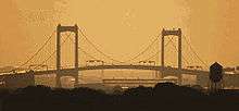
Just after crossing the Delaware River on the Walt Whitman Bridge, I-76 turns south and becomes the North-South Freeway, which carries Interstate 676 north to downtown Camden; the unsigned Route 76C connector runs east to U.S. Route 130 and Route 168. The exit numbers in New Jersey are backwards, running from east to west. Though signed eastbound towards Atlantic City, the route ends near Gloucester City in western Camden County at an interchange with Interstate 295.
From the I-676 interchange to the end, I-76 originally had local and express lanes in both directions, however, the barriers in both directions have been be removed due to rebuilding of the I-295, I-76, and Route 42 interchange. I-76 ends at an interchange with Interstate 295 on the Mount Ephraim/Bellmawr town line. The road becomes Route 42, continuing south on the North-South Freeway and then feeding into the Atlantic City Expressway to Atlantic City. While the South Jersey Transportation Authority (which owns the ACE) is not against the idea of making Route 42 (expressway part) and the ACE an eastern extension of I-76, they feel that making the change without a compelling reason would only add to motorists' confusion in southern New Jersey.
History
The majority of I-76, along the Pennsylvania Turnpike, includes the first long-distance rural freeway in the U.S.; the Ohio Turnpike and Schuylkill Expressway are also pre-Interstate freeways. By 1955, the section of that route from west of Youngstown to downtown Philadelphia was included in the planned Interstate Highway System, as was present I-76 from west of Youngstown to Akron. (Some early plans called for a new freeway along State Route 14 to the Pennsylvania state line; it is unclear when the proposed route was shifted to the Turnpikes.)
In 1957 the route from Cleveland east to Harrisburg, running roughly along the State Route 14 corridor in Ohio and the Turnpike in Pennsylvania, was labeled Interstate 80, and the rest of the route from Harrisburg to Philadelphia was assigned Interstate 80S. (Interstate 80N would have run from Harrisburg to New York City.) Interstate 78 was assigned to a route from Norwalk, Ohio, paralleling State Route 18 through Akron to Youngstown, and turning south there to end at the planned I-80.
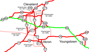

However, the 1957 numbering was drawn on a map from 1947, which did not include several changes that had been approved, specifically the Keystone Shortway across Pennsylvania. (The route in that corridor ran further north, along U.S. Route 6, and was numbered Interstate 84.) Thus, the final numbering, approved in 1958, assigned I-80 to the Norwalk-Youngstown route to reach the Keystone Shortway. The former alignment through Cleveland became Interstate 80N; the Turnpike was still not assigned a number from near Elyria (where I-80N and I-90 would split from it) to west of Youngstown. The route from west of Youngstown to Philadelphia was assigned Interstate 80S, and extended east to I-295 in New Jersey when the three-digit Interstates were assigned in 1959. (The planned I-80N in Pennsylvania became I-78.) Initial spurs of I-80S were I-180 (now I-176), I-280 (now I-276), I-480 (now I-476) and I-680 (now I-676, though it swapped with I-76 in 1972).
I-80 was realigned in Ohio by 1962, largely taking over former I-80N, which ran through Cleveland, joining the Turnpike southwest of Cleveland. However, while I-80N was planned to split from I-80 near Kent and run northwest to Cleveland along State Route 14, the new alignment of I-80 used the Turnpike between the crossing west of Youngstown and the crossing with State Route 14 at Streetsboro. The former I-80 from near Youngstown west to Akron became part of I-80S, as did a new alignment (already built as U.S. Route 224) from Akron west to I-71 east of Lodi; the rest of proposed I-80 west to near Norwalk (which would have crossed I-71 near Medina) was removed from the Interstate Highway System. Ca. 1971, I-80 was moved to the Turnpike between Streetsboro and southwest of Cleveland; the old route became I-480.

On April 16, 1963, due in part to the extension of I-79 south from the Pittsburgh area, Pennsylvania proposed a partial renumbering. A new number, tentatively designated I-76, would run from downtown Pittsburgh east on what was then I-70 (I-70S bypassed Pittsburgh to the south on what is now I-70) to the Pennsylvania Turnpike at Monroeville, and then east along the remainder of I-80S to I-295. I-80S would remain on the section of turnpikes from west of Youngstown to Monroeville. This was approved February 26, 1964, and included the renumbering of all X80 spurs to X76.
On June 29, 1970, a renumbering was approved in the Pittsburgh area, with the main effect being rerouting I-79 to bypass Pittsburgh to the west on the former I-279. I-279 was moved to the former I-79 north of downtown, and the former I-79 from downtown southwest to new I-79 became a western extension of I-76. (It was then that I-876 was designated for former I-479.) A realignment and extension of I-76 into Ohio, taking over the rest of I-80S to I-71 east of Lodi, was approved January 11, 1972. The former I-76 from Monroeville west into downtown Pittsburgh became I-376, and I-279 was extended southwest from downtown along former I-76 to I-79. (I-876 was renumbered to I-579 then.) Signs in Ohio were changed September 1, 1972; the old I-80S signs remained for about a year.
On August 29, 1972, a swap of I-76 and I-676 in Philadelphia and Camden was approved. I-76 had been routed along the Vine Street Expressway and Ben Franklin Bridge (now I-676) through Center City Philadelphia, while I-676 used the Schuylkill Expressway and Walt Whitman Bridge to bypass downtown to the south. The switch was made because of delays in building the Vine Street Expressway, better interchange geometry at the splits, and that the Ben Franklin Bridge ends in city streets, rather than in expressway grade.
The renumbering of a Philadelphia Interstate to 76 in the years leading up to the Bicentennial Celebration of the 1776 signing in Philadelphia of the Declaration of Independence gives rise to the question of the highway number being an intentional tribute to the Spirit of '76. USDoT research into federal documentation of the I-76 renumbering found no evidence of this being intentional.[6]
Exit list
Ohio and Pennsylvania
In Ohio and Pennsylvania, the routes are composed mostly of turnpikes with the exceptions in east-central Ohio and eastern Pennsylvania. The exit numbers on the turnpike portions in Ohio follow the mileage markers for the Ohio Turnpike.
New Jersey
| County | Location | mi[7] | km | Exit | Destinations | Notes |
|---|---|---|---|---|---|---|
| Philadelphia | Philadelphia | 3.08 | 4.96 | Pennsylvania state line | ||
| Delaware River | 3.08 | 4.96 | Walt Whitman Bridge (Westbound toll, cash or E-ZPass) | |||
| Camden | Camden | 2.3 | 3.7 | 354 | Eastbound exit and westbound entrance; connection to US 130 is NJ 76C; signed with PA exit number | |
| 2.21 | 3.56 | 2 | Westbound exit and eastbound entrance | |||
| Gloucester City | 1.15 | 1.85 | 1D | Westbound exit and eastbound entrance | ||
| 1C | Eastbound exit and westbound entrance | |||||
| 0.76 | 1.22 | 1C | Westbound exit and eastbound entrance (provides a U-turn for nonexistent movements at the I-295 interchange) | |||
| Mount Ephraim | 0.13 | 0.21 | 1B | I-295 south exit 26A, north exit 27. | ||
| Bellmawr | 0.00 | 0.00 | 1A | I-295 south exit 26A, north exit 27; eastbound exit and westbound entrance. | ||
| Continuation beyond I-295 | ||||||
1.000 mi = 1.609 km; 1.000 km = 0.621 mi
| ||||||
Auxiliary routes
- Interstate 176 runs north from I-76 at Morgantown, Pennsylvania to U.S. Route 422 outside of Reading.
- Interstate 276 runs east from I-76 at Valley Forge, Pennsylvania along the Pennsylvania Turnpike to the Delaware River-Turnpike Toll Bridge, where it currently ends at the state line. Interstate 95 continues north along the New Jersey Turnpike. It will be truncated by several miles at its east end when the Pennsylvania Turnpike/Interstate 95 Interchange Project is completed and I-95 is connected.
- Interstate 376 runs west from I-76 at Monroeville, Pennsylvania through Pittsburgh, becomes a toll road northwest of the airport, intersects I-76 again, and terminates at I-80 in Sharon.
- Interstate 476 begins at Interstate 95 near Chester, Pennsylvania and heads north, crossing I-76 near Conshohocken and I-276 near Plymouth Meeting. From there it continues north on the Pennsylvania Turnpike Northeast Extension to Interstate 81 at Clarks Summit, Pennsylvania, north of Scranton. I-476 is the longest three-digit Interstate.
- Pennsylvania Route 576 is a planned southern bypass of Pittsburgh, though it could become Interstate 576.
- Interstate 676 is a loop through downtown Philadelphia and Camden, New Jersey, crossing the Ben Franklin Bridge. It runs through several traffic signals in Philadelphia, in violation of Interstate standards.
- Interstate 876 was the number for present Interstate 579 in Pittsburgh in the early 1970s.
See also
 U.S. Roads portal
 New Jersey portal
 Ohio portal
 Pennsylvania portal
 Pittsburgh portal
 Philadelphia portal
Notes
- ^ Gregory Pietsch, More I-76 and Atlantic City Expressway, misc.transport.road June 10, 2002 (message ID: zc9N8$.56b22.28752931@newssvr15.news.prodigy.com )
References
- ↑ Federal Highway Administration (2002-10-31). "FHWA Route Log and Finder List: Table 1". Retrieved 2007-03-28.
- ↑ "Pennsylvania Highways: Interstate 76". Pahighways.com. Retrieved 2013-01-29.
- ↑ "Pages - I-71&I-76 Interchange Reconstruction". Dot.state.oh.us. Retrieved 2013-01-29.
- ↑ "68-turbine wind farm to be constructed in Somerset Co.".
- ↑ "Pennsylvania Turnpike Plans to Construct New Six Lane Susquehanna River Bridge".
- ↑ "Was I-76 Numbered to Honor Philadelphia for Independence Day, 1776?". Retrieved 2006-09-17.
- ↑ "I-76 Straight Line Diagram" (PDF). New Jersey Department of Transportation. Retrieved September 9, 2012.
- Was I-76 Numbered to Honor Philadelphia for Independence Day, 1776?
- Kurumi - 3-digit Interstates from I-76
- Ohio Maps and Highway Proposals
- roadfan.com (2005). Cleveland Maps. Retrieved December 15, 2005.
- FHWA Route Log and Finder List
- Ohio straight line diagrams: Medina Summit Portage Mahoning Mahoning (Turnpike) (PDF)
- I-76 (New Jersey) straight line diagram (PDF)
External links
| Wikimedia Commons has media related to Interstate 76 (Ohio–New Jersey). |
 Geographic data related to Interstate 76 (Ohio–New Jersey) at OpenStreetMap
- Interstate-Guide.com
| Signed | |||||||||||
|---|---|---|---|---|---|---|---|---|---|---|---|
| Unsigned | |||||||||||
| Lists |
| ||||||||||
Major Interstates highlighted | |||||||||||
| ||