Interstate 69
| |
|---|---|
|
Open segments Proposed segments | |
| Route information | |
| Length: |
820.2 mi (1,320.0 km) Original length 355.8 miles (572.6 km)[1] |
| History: |
|
| Major junctions | |
| South end: |
|
| |
| East end: |
|
| Location | |
| States: | Texas, Mississippi, Tennessee, Kentucky, Indiana, Michigan |
| Highway system | |

.png)
Interstate 69 (I-69) is an Interstate Highway in the United States currently consisting of seven disjointed parts with an original continuous segment from Indianapolis, Indiana, northeast to the Canada–US border in Port Huron, Michigan, at 355.8 miles (572.6 km). The remaining separated parts are variously completed and posted or unposted parts of an extension southwest to the Mexican border in Texas. Of this extension—nicknamed the NAFTA Superhighway because it would help trade with Canada and Mexico spurred by the North American Free Trade Agreement—five pieces near Corpus Christi, Houston, northwestern Mississippi, Memphis, and Evansville have been newly built or upgraded and signposted as I-69. A sixth segment of I-69 through Kentucky utilizing that state's existing parkway system and a section of I-24, was established by federal legislation in 2008 but only a portion is signposted. A section of the previously existing Western Kentucky Parkway from Eddyville to Nortonville was approved and signposted in late 2011, with the Pennyrile Parkway between Nortonville and Henderson being signed as I-69 in 2015.[2] This brings the total length to about 680 miles (1,090 km).
The proposed extension evolved from the combination of Corridors 18 and 20 of the National Highway System as designated in the Intermodal Surface Transportation Efficiency Act of 1991, but the federally recognized corridor also includes connecting and existing infrastructure, including I-94 between Chicago and Port Huron and several spurs from I-69. Among these proposed spurs are an extension of I-530 from Pine Bluff, Arkansas, an upgrade of U.S. Route 59 (US 59) from Texarkana, Texas, and a split in southern Texas to serve three border crossings at Laredo, Pharr, and Brownsville.
In August 2007, I-69 was selected by the United States Department of Transportation as one of six Corridors of the Future, making it eligible for additional federal funding and streamlined planning and review. This funding has since been withheld causing some states to suspend construction indefinitely.[3]
Route description
I-69 currently exists as a number of distinct segments:
- The original (with later additions), fully completed route from Indianapolis, Indiana, to the Blue Water Bridge at Port Huron, Michigan (Section of Independent Utility (SIU) 1);
- Portions of the Indianapolis beltway (I-465), though not currently signed as such (SIU 2);
- A 93-mile (150 km) section from I-64 north of Evansville, Indiana to SR 37 near Bloomington, Indiana, sections 1-4 of (SIU 3);
- A 21-mile (34 km) section of former Interstate 164 near Evansville, Indiana, south from I-64 to a temporary end at US 41; recently signed as I-69 (SIU 4);
- The upgraded portions of the Kentucky Parkway system: Purchase, Western Kentucky and Pennyrile parkways (SIU 5) and (SIU 6);
- A 42-mile (68 km) section from Tunica Resorts, Mississippi, to the I-40/I-69/State Route 300 (SR 300) interchange in Memphis, Tennessee part of (SIU 9) and (SIU 10);
- The existing US 59 freeway from Rosenberg, Texas, to Cleveland, Texas (SIU 19);
- A 7.8-mile (12.6 km) segment of US 77 from south of State Highway 44 (SH 44) to I-37 near Corpus Christi, Texas (SIU 22), designated as I-69 in August 2011 and re-designated as I-69E on May 30, 2013[4]
- An 18-mile (29 km) section of US 281 from I-2 in Pharr, Texas to Edinburg, Texas, designated as I-69C on May 30, 2013.[4]
- A 53.3-mile (85.8 km) section of US-77 (and part of US 83) from the Veterans International Bridge at Brownsville, Texas to Raymondville, Texas, designated as I-69E on May 30, 2013 (SIU 23).[4][5]
- A 1.4-mile (2.3 km) section of both US 59 and Loop 20 in Laredo, Texas between the World Trade International Bridge and I-35, designated as I-69W on June 17, 2014.
| mi | km | |
|---|---|---|
| TX | 155.400 | 250.092 |
| LA | ||
| AR | ||
| MS | 21.393 | 34.429 |
| TN | 21.000 | 33.796 |
| KY | 148.090 | 238.328 |
| IN | 272.000 | 437.742 |
| MI | 202.317 | 325.598 |
| Total | 820.200 | 1,319.984 |
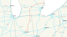
The original portion of Interstate 69 in Indiana (SIU 1 of the overall national plan) starts at an interchange with Interstate 465, the beltway around Indianapolis on the northeast side of that city. I-69 heads northeast to near Anderson, where it turns more easterly to provide indirect access to Muncie before turning more northerly towards Marion, and Fort Wayne. In Fort Wayne, I-69 runs along the western edge of the city while I-69's only current signed auxiliary route, I-469, loops east of the city. After crossing the Indiana East-West Toll Road (I-80/I-90) near Angola and Fremont, I-69 enters Michigan just south of Kinderhook.
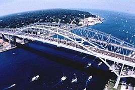
I-69 in Michigan runs north passing through Coldwater and Marshall. There it crosses I-94 east of Battle Creek. Near Olivet, I-69 begins to turn in a northeasterly direction passing through the Lansing metropolitan area. Here I-69 is cosigned with I-96 as an overlap west of Lansing, the only such palindromic pairing in the Interstate Highway System. Where it splits from I-96, I-69 turns east, both in compass direction and in signed direction, and heads north of Lansing and through Flint (where it crosses I-75) to a junction with I-94 just outside Port Huron. At its eastern terminus, I-69 joins I-94 to the Blue Water Bridge across the St. Clair River, where traffic continues on Highway 402 in the Canadian province of Ontario to London, Ontario.
The new section of Interstate 69 in southern Indiana presently begins at the I-64/I-164/SR 57 interchange north of Evansville, at the boundary between the SIU 3 and SIU 4; from there, it runs north to SR 68. Construction was completed on November 19, 2012 on a 67-mile (108 km) segment (SIU 3, Section 1-3). This extension takes the route north-northeast from there to SR 64 near Oakland City, then north-northeast to US 50/US 150 at Washington and finally northeast to US 231 near the Crane Naval Surface Warfare Center. Construction for the final new terrain segment (SIU 3, Section 4), which takes I-69 from Crane NSWC northeast to SR 37 on the southwest side of Bloomington, was completed in December 2015. From there the existing SR 37 expressway corridor, including Sections 5 (Bloomington to Martinsville) and 6 (Martinsville to Indianapolis) of I-69's SIU 3, is currently being upgraded to full Interstate Highway standards all the way north-northeast to I-465 on the southwest side of Indianapolis.
The new I-69 in Mississippi and Tennessee starts at an at-grade intersection with the former route of Mississippi Highway 304 (MS 304) in Banks, Tunica County, Mississippi. It continues roughly north-northeast, crossing into DeSoto County, to a partial interchange with the current route of MS 304, then runs easterly to an interchange with I-55 in northern Hernando. It then continues north, overlapping I-55 to the Tennessee state line, and continues northward concurrently with I-55 to the south side of Memphis. It then follows I-240 northward through downtown before joining I-40. Presently, the northern end of this section of I-69 is at the I-40/I-69/SR 300 interchange on the north side of Memphis. This portion of the route was the first "section of independent utility" (SIU) of the proposed extension to be signed as part of the national I-69 route, and the first portion designed as part of the extension.
Planned extensions
Current progress
.svg.png)
As of 2015, SIU 1 (all of original I-69 north of Indianapolis) and SIU 2 (which will likely use I-465 around Indianapolis, but is as yet unsigned) are open, as is SIU 5 in Kentucky, the short SIU 10 in northwestern Mississippi, and part of SIU 9 in the Memphis, Tennessee area. SIU 6 in Kentucky is built as a freeway, but not yet up to Interstate standards in all areas. On June 6, 2008, President George W. Bush signed HR 1195, designating the Purchase Parkway as Future I-69. Kentucky officials planned to place I-69 signs on the Pennyrile Parkway, Western Kentucky Parkway and Purchase Parkway in 2008, but the Federal Highway Administration (FHWA) has not yet given Kentucky approval to do so for the entire route.[6][7][8][9] Kentucky has been making spot improvements to its parkways to bring them up to interstate standards in anticipation of the I-69 designation. Indiana examined building most of SIU 3 as a toll road, but quickly reverted to making it toll-free in 2006 with an announcement to that effect by Indiana Governor Mitch Daniels after widespread opposition from I-69 opponents and supporters alike. Indiana has been using funds from the $3.8 billion Indiana Toll Road lease deal along with public-private partnerships to construct SIU 3 between Indianapolis and Evansville.
Texas continues to actively pursue completing its portion of I-69 by upgrading existing US and state highways along the I-69 corridor to interstate standards. Several portions of the 15 SIUs in Texas are currently being worked on, with active construction in progress on US-59 from SH-99 to Kendleton (SIU 20), and on US-77 between Robstown and Kingsville (SIU 22).[10] Four mainline SIUs outside of Texas are under construction; SIU 3 in Indiana (using $700 million from the 2006 Major Moves deal), SIU 7[11] and SIU 9 in Tennessee; also a small part of SIU 13 in Arkansas (Monticello Bypass). Portions of these SIUs are open to traffic.[12][13] Most of the remaining parts of the mainline are in the environmental impact statement (EIS) stages; FHWA has signed records of decision approving the final EIS for SIUs 11,[14] 12,[15] and 13.[16]
Progress delays
While federal legislation established a mandate to extend I-69 from Indiana to Texas, it did not provide funding for its construction. I-69 construction must compete against other projects for traditional funding. Despite approval of several segments, work has been completed on only a few scattered segments, due in part to increasing costs for construction materials and machinery. As a result, several states have indicated that construction of I-69 may not be possible without the use of tolls as the primary means to finance building the highway. Tennessee, Arkansas, and Mississippi passed legislation authorizing toll roads within each state, but have not applied tolling to their sections of I-69 due to the widespread unpopularity of toll roads in these states. A bridge over the Ohio River, which was to have been built along I-69 to connect Indiana with Kentucky, stalled in 2004 due to each state not having enough funding for it. In 2016, both states reached an agreement to restart environmental studies and develop a funding strategy for the Ohio River crossing. Tennessee and Mississippi have suspended work on I-69 indefinitely, due to a lack of funding to build the highway outside of the Memphis metropolitan area. Arkansas has halted work on its mainline portion of I-69, aside from the Monticello Bypass. A spur known as the I-530 connector is however under construction. Louisiana officials have stated that its current priority is completing Interstate 49, and it will focus on constructing its portion of I-69 after it finishes work on I-49. In contrast, Texas, Kentucky and Indiana have been advancing construction of I-69 within each state through traditional funding sources, tolls, and innovative financing methods, such as public-private partnerships.
Texas

In Texas, I-69 planning has become part of the Trans-Texas Corridor (TTC) studies. This part of the TTC, called I-69/TTC, includes I-69 and all of its spurs authorized by Congress. It will extend from three border crossings, at Laredo, Pharr, and Brownsville, along US 59, US 281, and US 77 towards Victoria. After the three branches join, I-69 will continue along the general US 59 corridor through Houston to Tenaha, where it will turn easterly to Louisiana along US 84. In metro Houston, I-69 will follow the US 59 freeway corridor through town. A branch (I-369) continues north on US 59 from Tenaha to Texarkana, where it will eventually connect to Interstates 30 and 49. Most of the proposed I-69 route in Texas already exists as four-lane highways, with a lengthy freeway section stretching north and south of Houston along US 59 and shorter freeway sections of US 77, US 83, and US 281 in the Rio Grande Valley.
The I-69/TTC project has been split into 15 SIUs, which match the original ones but do not share numbers. SIUs 1 to 8 (original 16 to 23) cover the mainline along the "Interstate 69 East" branch to the Mexican border at Brownsville. The "Interstate 69 Central" branch to Pharr is SIUs 9, 11, and 12 (original 24 to 26). The "Interstate 369" and "Interstate 69 West" branches to Texarkana and Laredo, respectively are SIUs 13 and 14 (original 29 and 30), and two connections to Brownsville and Pharr are SIUs 10 and 15 (original 31 and 32). The I-69/TTC study also includes SIU L-CC, a connection between Freer and Corpus Christi that was not in the 2000 study.[17] The Texas Department of Transportation (TxDOT) originally considered building the I-69/TTC over new terrain paralleling US 59, US 77, and US 281.
Responding to widespread opposition from environmental groups and property rights activists, TxDOT announced in June 2008 that it will complete I-69 by upgrading the existing US 59, US 77, and US 281 roadways to Interstate standards through rural areas, with bypasses around urban centers along the route. Instead of building the Trans-Texas Corridor as originally planned, TxDOT now plans to finance upgrading the existing highways to I-69 through private sector investment. Under the proposed arrangement, I-69 would remain toll-free where it overlaps pre-existing highways, while bypasses of cities may be tolled. The private firms awarded contracts for I-69 would also build and operate toll roads throughout the state; some of those revenues would then be applied to I-69 construction.
A stated goal of TxDOT's I-69 initiative is that "existing suitable freeway sections of the proposed system be designated as I-69 as soon as possible."[18] In response to TxDOT's request, a six-mile (9.7 km) segment of US 77 between I-37 and State Highway 44 (SH 44) near Corpus Christi was approved for "I-69" designation by FHWA in August 2011, and was approved by the American Association of State Highway and Transportation Officials (AASHTO) in October 2011;[19] signage was posted at an official ceremony on December 5, 2011;[20] it was re-signed as I-69E on May 29, 2013.
At the May 18, 2012, meeting of AASHTO, 35 miles (56 km) of US 59 from I-610 in Houston to Fostoria Road in Liberty County were also approved as ready for I-69 signage.[21]
On May 29, 2013, the Texas Transportation Commission gave approval to naming completed Interstate-standard segments of US 77 and US 281 as I-69. US 77 through Cameron and Willacy counties will be signed as I-69E, including 52 miles (84 km) of existing freeway starting at the Rio Grande in Brownsville and running north past Raymondville. The 13 miles (21 km) of US 281 freeway in Pharr and Edinburg will be signed as I-69C.[22]
The section of US-59 inside the I-610 loop that runs through downtown Houston was approved by the FHWA for designation as I-69 on March 9, 2015, and approved for signage as such by the Texas Transportation Commission on March 24, 2015.[23]
Louisiana, Arkansas, and Mississippi


The nearly 350-mile portion of the I-69 extension from south of Clarksdale, Mississippi to the Louisiana/Texas state line will be built as a new-terrain route that parallels existing US and state highways in some locations. As well as covering the part in Texas northeast of Nacogdoches, SIU 16 also extends into Louisiana, ending at US 171 near Stonewall. SIU 15 continues around the south and east sides of the Shreveport area, crossing I-49 and ending at I-20 near Haughton.[24] SIU 14 extends northeast from I-20 to US 82 near El Dorado, Arkansas,[25] and SIU 13 continues northeast to US 65 near McGehee, mainly paralleling US 278.[26] Also included in Corridor 18, as SIU 28, is an extension of I-530 from Pine Bluff south along the US 425 corridor to I-69 west of Monticello; a short piece at the south end opened in mid-2006 as Highway 530.[27] The Charles W. Dean Bridge, SIU 12, will cross the Mississippi River between McGehee, Arkansas and Benoit, Mississippi, while SIU 11 will parallel US 61 to Tunica Resorts.[28] SIU 10, the first completed portion of the I-69 extension, runs east from Robinsonville to I-55 near Hernando, and opened in late 2006.[29] With the record of decision signed in 2007, the FHWA authorized MDOT to add I-69 signs on I-55 from the I-55/I-69 interchange in Hernando to the Tennessee state line.
Tennessee, Kentucky, and southern Indiana
.JPG)
From a point south of Clarksdale, Mississippi to Henderson, Kentucky, most of the I-69 alignment will consist of upgrades to existing US and interstate routes and substandard freeways, although some sections will be built as bypasses around cities and towns along the route.
I-69 SIU 9 overlaps I-55 into Memphis, Tennessee, switching there to I-240 and then I-40 before leaving onto the short State Route 300 (SR 300) connection and then paralleling US 51 to near Millington. On January 18, 2008, FHWA authorized the Tennessee Department of Transportation (TDOT) to erect I-69 signs on I-55, I-240, and I-40 from the Mississippi state line to the I-40/SR 300 interchange. The proposed Interstate 269 will bypass this part of I-69, beginning where I-69 joins I-55 in Mississippi and ending near Millington, and will include the northern part of SR 385 near Millington. SIU 8 will continue beyond Millington, near US 51, to I-155 near Dyersburg, while SIU 7 will use the existing US 51 freeway and new bypasses to the state line at Fulton, Kentucky.[30] TDOT Commissioner John Schroer plans for SIU 7 to be gradually completed over the next 10 years.[31] It is unclear if I-69 through Tennessee will ever be completed, as the state has suspended work indefinitely on SIU 8 due to a lack of funding.
In Kentucky, I-69 mostly follows existing freeways originally built as toll roads. SIU 6 follows the Julian M. Carroll Purchase Parkway (originally called just the Purchase Parkway) and I-24 from Fulton to Eddyville, while SIU 5 continues along the Wendell H. Ford Western Kentucky Parkway (originally called just the Western Kentucky Parkway) and the Edward T. Breathitt Pennyrile Parkway (originally called just the Pennyrile Parkway) from Eddyville to Henderson. While these parkways received the I-69 designation by federal legislation signed in 2008, they will require upgrading to meet Interstate standards—but will not need as much work as in other states, where entirely new highways must be built. The interchanges, many of which were designed for tollgates (where all ramp traffic must stop), must be replaced.[32]
On August 31, 2011, Kentucky Governor Steve Beshear announced an agreement between the state and FHWA which will allow the Kentucky Transportation Cabinet to erect I-69 signage along the new Interstate's 17-mile (27 km) overlap with I-24 and the 38-mile (61 km) stretch of the Wendell H. Ford Western Kentucky Parkway between I-24 and the Edward T. Breathitt Pennyrile Parkway. Signage is expected to be placed in the fall of 2011, with construction on necessary upgrades of the portion of the Wendell H. Ford Western Kentucky Parkway expected to be bid in September.[33] On October 25. 2011, I-69 was officially designated by Governor Steve Beshear along the Wendell H. Ford Western Kentucky Parkway along a 55-mile (89 km) stretch between Eddyville and Nortonville.[34] Signage and mile markers were replaced on the 38-mile (61 km) stretch of the Wendell H. Ford Western Kentucky Parkway in mid-December 2012.[35] An additional 42.6 miles along the Pennyrile Parkway from the Western Kentucky Parkway to KY 425, south of Henderson was designated and resigned on November 16, 2015.[36]
The Indiana and Kentucky Governors agreed on June 30, 2016 to spend a combined $17 million for an environmental and design study to determine how the two states will pay for a bridge spanning the Ohio River and where it will run. This is the second study conducted by the two states. The first study was commissioned in 2001 and a preliminary report in 2004 put the cost of a bridge at $1.4 billion.[37] The preferred alternative for SIU 4 was to leave the Edward T. Breathitt Pennyrile Parkway near its north end and cross the Ohio River to I-164 near Evansville, Indiana, and then use I-164 to I-64.[38] At the October 18, 2013, AASHTO meeting, an INDOT request to redesignate I-164, as part of I-69, was approved, pending concurrence from the FHWA.[39]
SIU 3, connecting I-69 to I-465 in southern Indianapolis, will roughly parallel State Road 57 (SR 57) and SR 45, and will use an upgraded version of the existing SR 37 from just south of Bloomington to a point just south of Indianapolis. The segment from I-69 to Bloomington is currently under construction with a 67-mile (108 km) stretch from Evansville to the Crane Naval Surface Warfare Center completed on November 19, 2012.[40] and the remaining 27-mile (43 km) portion was opened to traffic on December 9, 2015.[41] Construction is also underway on upgrading a 21-mile section of SR 37 from Bloomington to just south of Martinsville to interstate standards.[42] The final segment from Martinsville to Indianapolis is currently under Tier 2 environmental review.[43] Finally, it has long been assumed that SIU 2 will most likely follow I-465 around the city, though INDOT has never officially confirmed that. The location of an interchange with either I-70 or I-465 has not yet been determined.
History
Original route
A route from Indianapolis northeast via Fort Wayne to I-80/I-90 near Angola was added to the proposed "Interregional Highway System" by the early 1940s. Unlike most of the routes, it was not drawn along an existing U.S. Highway corridor, except north of Fort Wayne (where it used US 27); most of it ran roughly parallel to SR 9 and SR 37.[44] The extension beyond Angola to I-94 near Marshall, Michigan, actually started out as part of what evolved into I-94. On early plans, the Chicago–Detroit route would have replaced US 112 (now US 12), splitting from I-80/I-90 at South Bend.[44][45] By 1947, the route had been shifted north to present I-94, along what was then US 12, but the connection to South Bend remained, splitting at Kalamazoo.[46]
The I-69 designation was assigned to the Indianapolis–Angola route in 1957, while the short South Bend–Kalamazoo route became proposed Interstate 67.[47] The I-67 designation was shifted east to the US 27 corridor by early 1958, eventually being absorbed into the extension of I-69 to I-94 near Marshall which was built in 1967.[48][49] The Federal-Aid Highway Act of 1968 authorized an additional 1,500 miles (2,400 km) of Interstates, to be chosen by FHWA; among Michigan's proposals was a 156-mile (251 km) extension of I-69 northeast and east via US 27 to Lansing, M-78 to Flint, and M-21 to Port Huron.[50] However, the FHWA initially only approved the route to I-475[51] in Flint.[52] The continuation to Port Huron was eventually approved in February 1987.[53] Michigan's 1,241-mile (1,997 km) portion of the Interstate system was completed in 1992, when the last piece of I-69 opened southwest of Lansing between I-96 and Charlotte.[54]
Extended route

The Intermodal Surface Transportation Efficiency Act of 1991 included two High Priority Corridors that would later become parts of a proposed cross-country extension of I-69:[55]
- (18) Corridor from Indianapolis, Indiana, to Memphis, Tennessee, via Evansville, Indiana.
- (20) US 59 Corridor from the Mexican border in Laredo, Texas, through Houston, to the vicinity of Texarkana, Texas.
Corridor 18 was extended southwest to Houston, where it connected to Corridor 20, by the Department of Transportation and Related Agencies Appropriations Act, 1993; the new definition read "Corridor from Indianapolis, Indiana, through Evansville, Indiana, Memphis, Tennessee, Shreveport/Bossier, Louisiana, and to Houston, Texas."[56] The National Highway System Designation Act of 1995 made further amendments to the description of Corridor 18, specifying that it would serve Mississippi and Arkansas, extending it south to the Mexican border in the Lower Rio Grande Valley, and adding a short connection at Brownsville, Texas. This act also specified that Corridors 18 and 20 were "future parts of the Interstate System", to become actual Interstates when built to Interstate standards and connected to other Interstates. Although the act designated Corridor 9 as I-99, no number was assigned to Corridors 18 and 20 yet.[57]
The Transportation Equity Act for the 21st Century (TEA-21), enacted in 1998, greatly expanded the definition of Corridor 18 to include the existing I-69, as well as I-94 between Port Huron and Chicago. A connection to Pine Bluff, Arkansas was added, and the extension to the Lower Rio Grande Valley was detailed as splitting into two routes just south of Victoria, one following US 77 and the other following US 59 and US 281 to the Rio Grande. This act also assigned the I-69 designation to Corridors 18 and 20, with the branches on US 77, US 281, and US 59 to the Rio Grande being "Interstate 69 East", "Interstate 69 Central", and "Interstate 69 West", respectively.[58] With TEA-21, the I-69 extension took shape, and remains today as those segments.[59]
In 2000, Corridors 18 and 20 were split into 32 Sections of Independent Utility (SIUs) as part of the I-69 (Corridor 18) Special Environmental Study.[60] In Texas, it was originally envisioned that private firms will build, operate, then transfer portions of the highway to the state after a specified period of time. Lawmakers in Kentucky once considered a bill that would authorize the re-tolling of three parkways slated to become part of I-69.
Opposition and controversy
The construction of the I-69 extension has angered environmentalists. In particular, the portion of the route in Indiana would run through wetlands, existing farmland, and forested areas, and cut through geologically sensitive karst topography, which environmentalists argue threatens to pollute underground water systems and harm the rare species that live there.[61][62] Fiscal conservatives also oppose completion of I-69, arguing that federal legislation establishing the I-69 corridor amounts to an unfunded mandate imposed by the federal government upon the states through which the highway will travel, as the legislation requires states to pursue construction of their portions of I-69, but provides no funding mechanism to cover its estimated $25 billion cost, thereby leaving cash-strapped states to figure out how to finance its construction.
Junction list
- Texas
-
 US 59 in Rosenberg. The highways travel concurrently to north-northeast of Splendora.
 -
 I‑610 in Houston
 -
 I‑45 in Houston
 -

 I‑10 / US 90 in Houston
 - I‑610 in Houston
- Gap in route
- Louisiana
- Unbuilt
- Arkansas
- Unbuilt; Monticello Bypass in the works.
- Mississippi
-
 MS 713 east-northeast of Robinsonville. The highways travel concurrently for approximately 3.73 miles (6.00 km).
 -
 I‑55 in Hernando. The highways travel concurrently to Memphis, Tennessee.
 - Tennessee
-
 US 51 in Memphis
 -
 I‑55 / I‑240 in Memphis. I-69/I-240 travels concurrently through Memphis.
 -
 US 78 in Memphis
 -


 US 51 / US 64 / US 70 / US 79 in Memphis
 -
 I‑40 / I‑240 in Memphis. I-40/I-69 travels concurrently through Memphis.
 - US 51/
 SR 300 in Memphis
 - Gap in route
- Kentucky
-
 I‑24 south of Calvert City. The highways travel concurrently to Eddyville.
 -
 US 62 in Calvert City
 -
 US 62 / US 641 in Kuttawa
 - US 62 in Eddyville
-

 Western Kentucky Parkway / Pennyrile Parkway north-northeast of Nortonville
 -
 US 41 in Madisonville
 - US 41 near Henderson
- Gap in route
- Indiana
- US 41 in Evansville
-
 I‑64 west-northwest of Elberfeld
 -

 US 50 / US 150 east of Washington
 -
 US 231 west-northwest of Scotland
 -
 SR 37 near Bloomington
 - Gap in route
-


 I‑465 / US 31 / US 52 / US 421 in Indianapolis
 -
 US 35 east-northeast of Alexandria. The highways travel concurrently to Gas City.
 -
 US 224 in Markle
 -

 I‑469 / US 33 east of Roanoke. I-69/US 33 travels concurrently to Fort Wayne.
 -
 US 24 in Fort Wayne. The highways travel concurrently through Fort Wayne.
 -
 US 30 / US 33 in Fort Wayne. I-69/US 30 travels concurrently through Fort Wayne.
 -
 US 27 in Fort Wayne
 - I‑469 / US 24 / US 30 in Fort Wayne
-
 US 6 west-northwest of Waterloo
 -
 US 20 west of Angola
 -

 I‑80 / I‑90 west-northwest of Fremont
 - Michigan
-
 US 12 in Coldwater
 -
 I‑94 northwest of Marshall
 -
 I‑96 in Lansing. The highways travel concurrently to northwest of Waverly.
 -
 I‑496 west of Lansing
 -
 US 127 north-northwest of East Lansing
 -

 I‑75 / US 23 southwest of Flint
 -
 I‑475 in Flint
 - I‑94 north of Marysville. The highways travel concurrently to the Canada–United States border in Port Huron.
- I‑94/
 Highway 402 at the Canada–United States border in Port Huron
Auxiliary routes
- Interstate 69C (Texas)
- Interstate 69E (Texas)
- Interstate 69W (Texas)
- Interstate 169 (Tennessee)—proposed
- Interstate 169 (Texas)
- Interstate 269 (Mississippi–Tennessee)
- Interstate 369 (Kentucky)—planned
- Interstate 369 (Texas)
- Interstate 469 (Indiana)
See also
-
 U.S. Roads portal
References
- ↑ DeSimone, Tony (October 31, 2002). "Table 1: Main Routes of the Dwight D. Eisenhower National System Of Interstate and Defense Highways as of October 31, 2002". Route Log and Finder List. Federal Highway Administration.
- ↑ "New Interstate 69 designated in Ky.". Nashville, TN: WSMV-TV. October 26, 2011. Retrieved October 26, 2011.
- ↑ "DOT Selects Six National "Corridors of the Future"". Retrieved August 10, 2012.
- 1 2 3 Staff (May 30, 2013). "Interstate 69 Comes to Texarkana and the Valley" (Press release). Alliance for I-69 Texas. Retrieved May 31, 2013.
- ↑ Clark, Steve (May 29, 2013). "SH 550 ribbon-cutting crowd gets big I-69 news". The Brownsville Herald. Retrieved May 31, 2013.
- ↑ "HR-1195 Text" (PDF). Retrieved January 13, 2012.
- ↑ "KY I-69 Designation Cruises Through Congress" (Press release). Representative Whitfield. May 4, 2008. Archived from the original on November 4, 2009.
- ↑ Interstate 69 Legislation, Tristate Homepage.com Archived May 14, 2008, at the Wayback Machine.
- ↑ "President Bush Signs HR-1195" (Press release). The White House. June 6, 2008.
- ↑ http://i69texasalliance.com/ResourcesPDFs/I69.TxDOT%20Funding%20Program%20Map.%20Nov2014.pdf
- ↑ http://www.wpsdlocal6.com/story/32028845/progress-being-made-on-future-interstate-69-in-union-city
- ↑ "TDOT I-69 Segment 9 Newsletter, January 2007" (PDF). Retrieved January 13, 2012.
- ↑ "I-69 Indianapolis to Evansville Extension (Official Site)". I69indyevn.org. Retrieved January 13, 2012.
- ↑ Staff. "I-69 Project Page". Mississippi Department of Transportation. Retrieved November 1, 2010.
- ↑ "Great River Bridge Compact Hears Update" (Press release). Arkansas Highway and Transportation Department. November 30, 2000.
- ↑ "Location for Proposed I-69 in South Arkansas Receives Federal Approval" (Press release). Arkansas Highway and Transportation Department. May 24, 2006.
- ↑ Staff. "I-69/TTC (Northeast Texas to Mexico)". Texas Department of Transportation. Retrieved August 31, 2007.
- ↑ Staff. "What's Next for I-69 Texas?". Texas Department of Transportation. Retrieved August 31, 2011.
- ↑ "Portion of US 77 Approved as Part of US Interstate System" (Press release). Texas Department of Transportation. Retrieved August 31, 2011.
- ↑ "First I-69 signs going up on US 77 in December".
- ↑ Vitale, Marty (May 19, 2012). "Report to SCOH" (PDF) (Report). Traverse City, MI: American Association of State Highway and Transportation Officials.
- ↑ Essex, Allen (May 30, 2013). "I-69 Comes to the Valley: 111 Miles Added to Interstate System". Valley Morning Star. Harlingen, TX. Retrieved June 3, 2013.
- ↑ Minute Order 5 - March 25, 2015, Texas Transportation Commission
- ↑ Staff. "I-69, SIU 15 Project Site". Louisiana Department of Transportation and Development. Retrieved August 31, 2007.
- ↑ Staff. "Interstate 69 Shreveport to El Dorado". Arkansas Highway and Transportation Department and Louisiana Department of Transportation and Development. Retrieved August 31, 2007.
- ↑ Staff. "Interstate 69 El Dorado to McGehee". Arkansas Highway and Transportation Department. Retrieved August 31, 2007.
- ↑ Riggin, Amy (May 26, 2006). "Interstate Plan is Moving Forward". Pine Bluff Commercial. Archived from the original on February 20, 2010.
- ↑ "I-69 Robinsonville to Benoit". Mississippi Department of Transportation. Retrieved August 31, 2007.
- ↑ Risher, Wayne (July 20, 2006). "New Leg of I-69 to Open on Oct. 3". The Commercial Appeal.
- ↑ Staff. "Interstate 69 Project". Tennessee Department of Transportation. Retrieved August 31, 2007.
- ↑ Patch, Elvin (February 23, 2013). "TDOT commissioner visits Dyersburg, speaks on I-69 (02/23/13)". Dyersburg State Gazette. Retrieved May 5, 2013.
- ↑ "Governor Fletcher Unveils I-69 Corridor Designation" (Press release). Commonwealth of Kentucky. May 15, 2006. Archived from the original on November 26, 2007.
- ↑ "Governor Beshear announces approval of historic I-69 agreement" (Press release). Governor of Kentucky. August 31, 2011. Archived from the original on December 2, 2011.
- ↑ "Governor puts I-69 on the map". WPSD-TV. October 25, 2011.
- ↑ Todd, Keith (December 15, 2012). "I-69 is Official with New Signs and Mile Points in Lyon, Hopkins & Trigg Counties". SurfKY News. Retrieved December 30, 2012.
- ↑ http://www.wtvq.com/2015/11/16/new-red-white-and-blue-highway-signs-for-42-miles-of-i-69/
- ↑ "Pence, Bevin sign agreement for I-69 bridge". Evansville Courier-Press. Jun 30, 2016.
- ↑ "Preferred Alternative Identified for I-69 Corridor Linking Henderson and Evansville" (Press release). Indiana Department of Transportation. February 11, 2004. Archived from the original on December 8, 2010.
- ↑ Vitale, Marty (October 28, 2013). "Special Committee on US Route Numbering Meeting Minutes for October 17, 2013 and Report to SCOH October 18, 2013" (PDF) (Report). Denver, CO: American Association of State Highway and Transportation Officials. Retrieved October 25, 2013.
- ↑ "Indiana I69 extension's 1st stretch opens Nov 19". Retrieved January 29, 2013.
- ↑ "Mayors: Next section of I-69 to open next week". Evansville Courier & Press. December 2, 2015. Retrieved December 2, 2013.
- ↑ "Officials Mark Start of Next I-69 Section". insideindianabusiness.com.
- ↑ http://www.in.gov/indot/projects/i69/2344.htm
- 1 2 Public Roads Administration (c. 1943). Routes of the Recommended Interregional Highway System (Map). Scale not given. Washington, DC: Public Roads Administration – via Wikimedia Commons.
- ↑ Public Roads Administration (1939). Proposed Interregional Highway System (Map). Scale not given. Washington, DC: Public Roads Administration – via Wikimedia Commons.
- ↑ Public Roads Administration. National System of Interstate Highways, August 2, 1947 (Map). Scale not given. Washington, DC: Public Roads Administration – via Wikimedia Commons.
- ↑ Public Roads Administration (August 14, 1957). Official Route Numbering for the National System of Interstate and Defense Highways (Map). Scale not given. Washington, DC: Public Roads Administration – via Wikimedia Commons.
- ↑ Michigan State Highway Department (April 25, 1958). Recommended Numbering: Interstate Highways in Michigan (Report). Michigan State Highway Department. Archived from the original on October 16, 2002.
- ↑ Public Roads Administration (June 27, 1958). Official Route Numbering for the National System of Interstate and Defense Highways (Map). Scale not given. Washington, DC: Public Roads Administration – via Wikimedia Commons.
- ↑ "Highway Additions Requested By State". The Owosso Argus-Press. Associated Press. November 14, 1968. p. 7. OCLC 9802802. Retrieved December 5, 2010.
- ↑ Michigan Department of Transportation (1984). Say Yes to Michigan!: Official Transportation Map (Map). c. 1:190,080. Lansing: Michigan Department of Transportation. Flint inset. OCLC 12701177.
- ↑ Federal Highway Administration (October 1, 1970). The National System of Interstate and Defense Highways (Map). Scale not given. Washington, DC: Federal Highway Administration – via Wikimedia Commons.
- ↑ Weingroff, Richard (July 16, 2013) [1998]. "Part I: History". The Dwight D. Eisenhower System of Interstate and Defense Highways. Federal Highway Administration. Retrieved August 18, 2013.
- ↑ "I-69 Now Open South of Lansing". Marshall Evening Chronicle. Associated Press. p. 20. OCLC 18110507. Retrieved August 17, 2013.
- ↑ "H.R.2950". Thomas.loc.gov. Retrieved January 13, 2012.
- ↑ "H.R. 5518". Thomas.loc.gov. Retrieved January 13, 2012.
- ↑ "S.440". Thomas.loc.gov. February 16, 1995. Retrieved January 13, 2012.
- ↑ "H.R. 2400". Thomas.loc.gov. Retrieved January 13, 2012.
- ↑ Staff. "NHS High Priority Corridors Description". Federal Highway Administration. Archived from the original on February 10, 2007. Retrieved August 31, 2007.
- ↑ I-69 (Corridor 18) Special Environmental Study (Report). February 7, 2000.
- ↑ "Indiana I-69". ELPC. Retrieved January 13, 2012.
- ↑ Bisbort, Alan. "The World This Week: Nafty Business: 'Super Corridor' will pave over the heart of America". The Valley Advocate.
Further reading
- Dellinger, Matt (2010). Interstate 69: The Unfinished History of the Last Great American Highway. New York: Scribner. ISBN 1-4165-4249-3.
- Higgs, Steven (2009). Twenty Years of Crimes Against Democracy: A Grassroots History of the I-69/NAFTA Highway. Los Angeles: New World Digital Publishing. ISBN 978-0-9825314-4-0.
External links
| Wikimedia Commons has media related to Interstate 69. |
- I69Info.com
- Highway Position: Is an Indiana Congressman introducing legislation to change the name of Interstate 69? (Snopes.com)
- Official DOT websites:
- I-69 Indianapolis-Evansville Study (Indiana Department of Transportation, SIU 3)
- Interstate 69 in Tennessee (SIUs 7, 8, and 9)
- Shreveport bypass (SIU 15)
- I-69 Driven By Texans, a Texas Department of Transportation site
| Signed | |||||||||||
|---|---|---|---|---|---|---|---|---|---|---|---|
| Unsigned | |||||||||||
| Lists |
| ||||||||||
Major Interstates highlighted | |||||||||||
| ||