Interstate 676
| |||||||
|---|---|---|---|---|---|---|---|
|
I-676 highlighted in red | |||||||
| Route information | |||||||
| Auxiliary route of I‑76 (east) | |||||||
| Maintained by PennDOT, DRPA, and NJDOT | |||||||
| Length: | 6.90 mi[1] (11.10 km) | ||||||
| Existed: | 1964[2] – present | ||||||
| History: | Completed in 1991[3] | ||||||
| Major junctions | |||||||
| West end: |
| ||||||
|
| |||||||
| South end: |
| ||||||
| Location | |||||||
| States: | Pennsylvania, New Jersey | ||||||
| Counties: |
PA: Philadelphia NJ: Camden | ||||||
| Highway system | |||||||
| |||||||

_map.svg.png)
Interstate 676 (abbreviated I-676) is an Interstate Highway that serves as a major thoroughfare through Center City Philadelphia, where it is known as the Vine Street Expressway, and Camden, New Jersey, where it is known as the northern segment of the North–South Freeway, as well as the Martin Luther King Jr. Memorial Highway. Its western terminus is at I-76 in Philadelphia near the Philadelphia Museum of Art and Fairmount Park. From there it heads east and is then routed on surface streets near Franklin Square and Independence Mall, home of the Liberty Bell, before crossing the Ben Franklin Bridge. On the New Jersey side of the bridge, the highway heads south to its southern terminus at I-76 in Gloucester City near the Walt Whitman Bridge. Between the western terminus and downtown Camden, I-676 is concurrent with U.S. Route 30 (US 30).
After World War II, freeway approaches were planned for both sides of the Ben Franklin Bridge, which was completed in 1926 and served as a part of US 30. In Pennsylvania, the Vine Street Expressway was planned to run along the northern edge of Center City Philadelphia to the Schuylkill River, while in New Jersey, the North-South Freeway was to head south along the Route 42 corridor. When the Interstate Highway System was created in the 1950s, this stretch of highway was a part of I-80S, with Interstate 680 continuing on the Schuylkill Expressway to the Walt Whitman Bridge. In 1964, the designations became I-76 and I-676, respectively, and in 1972 the two routes were switched onto their current alignments. I-676 in New Jersey was completed between I-76 and Morgan Boulevard by 1960 and north of there to downtown Camden by the 1980s. The Vine Street Expressway was opened from the Schuylkill Expressway to 18th Street by 1960 and east of there to I-95 on January 10, 1991 after several obstacles to construction. However, there are grade-level intersections in the connections between the Vine Street Expressway and the Ben Franklin Bridge.
Route description
| mi | km | |
|---|---|---|
| PA | 2.15[1] | 3.44 |
| NJ | 4.75[4] | 7.65 |
Pennsylvania
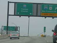
I-676 begins at an interchange with the Schuylkill Expressway (I-76 and US 30) in Philadelphia, Pennsylvania, heading to the east on the six-lane Vine Street Expressway concurrent with US 30. It immediately crosses the Schuylkill River on the Vine Street Expressway Bridge and comes to an interchange with 23rd Street and 22nd Street and the Ben Franklin Parkway that has access to the Philadelphia Museum of Art and the Franklin Institute.[5][6] From this point, the Vine Street Expressway enters a depressed road cut and passes under several streets, running along the northern edge of Center City Philadelphia.[6] Vine Street serves as a frontage road to the freeway at street level.[5][6] Within this alignment, there is an exit for PA 611 (Broad Street).[5] After passing under 10th Street in Chinatown, the last street the depressed alignment passes under, the highway rises up and reaches a split between the Vine Street Expressway, which continues to I-95, and I-676/US 30.[5][6] At this split, there is also an eastbound exit and westbound entrance for 8th Street.[5] After exiting the Vine Street Expressway, eastbound I-676/US 30 has a brief at-grade portion along southbound 6th Street to the Ben Franklin Bridge approach, an example of a non–limited access section of Interstate Highway.[5][6] Westbound I-676/US 30 has a ramp from the bridge to the Vine Street Expressway that intersects 7th Street and 8th Street at-grade.[5] From this point, I-676/US 30 crosses over the Delaware River on the seven-lane Ben Franklin Bridge, which also carries pedestrians and the PATCO Speedline.[5][6] This bridge and its approaches are maintained by the Delaware River Port Authority.[4]
New Jersey
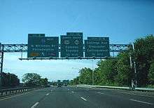
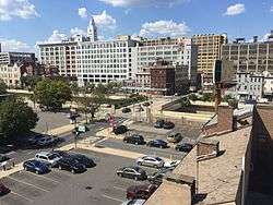
After crossing the bridge, the freeway enters the downtown area of Camden in Camden County, New Jersey and passes to the north of Campbell's Field.[4][6] Upon entering New Jersey, I-676 becomes signed as a north-south road.[4] There is a southbound ramp to 6th Street in Camden, which is near the toll booths for northbound traffic. After the toll plaza, US 30 splits from I-676 at an interchange, at which point I-676 turns south as a six-lane freeway called the Martin Luther King Memorial Highway or the North-South Freeway. Immediately after the US 30 split, there is an interchange with CR 537 (Market Street/Federal Street) and Martin Luther King Boulevard that provides access to downtown Camden.[4][6] From this point, I-676 continues south through urban areas of the city, passing over several streets and running immediately to the west of a Conrail Shared Assets Operations railroad line.[6] The road heads southwest on a viaduct over neighborhoods before the interchange with CR 607 (Kaighns Avenue) and Atlantic Avenue.[4][6] I-676 turns south at this junction and comes to the exit for Morgan Boulevard. Past Morgan Boulevard, the freeway crosses the North Branch of Newton Creek.[4] Here, I-676 ends at an interchange east of the Walt Whitman Bridge with I-76, CR 630, and Route 76C, the latter being an access road to US 130 and Route 168. The North-South Freeway becomes a part of I-76 past this interchange and continues into Gloucester City.[4][6]
History

The Ben Franklin Bridge was opened on July 1, 1926 and was designated to carry US 30 across the Delaware River.[7][8] A parkway called the Camden-Atlantic City Parkway was planned in 1932 to connect the Ben Franklin Bridge southeast to Atlantic City; this was never built.[9] After World War II, freeway connections were planned on both sides of the Ben Franklin Bridge. In Philadelphia, the Vine Street Expressway was planned to run along the Vine Street corridor to the present-day Schuylkill Expressway in 1945.[10] The North-South Freeway was proposed in New Jersey as a connection from the bridge south along the Route 42 corridor.[11] In 1950, the city of Philadelphia began planning the construction of the Vine Street Expressway, which would run along a depressed alignment through the city.[12]
When the Interstate Highway System was created in the 1950s, the Vine Street Expressway, Ben Franklin Bridge, and part of the North-South Freeway were to become a part of it.[13] In New Jersey, this Interstate was initially designated as FAI Corridor 109.[14] In 1958, this freeway was initially planned as I-895 and I-380 before the American Association of State Highway Officials designated it as a part of I-80S.[14][15] Meanwhile, I-680 was designated along the present-day Schuylkill Expressway between the Vine Street Expressway and the Walt Whitman Bridge. By 1960, the Vine Street Expressway had been completed between the Schuylkill Expressway and 18th Street. The portion of I-80S in New Jersey on the North-South Freeway had opened south of Morgan Boulevard by this time.[15] On April 16, 1963, Pennsylvania wanted to renumber its Interstate numbers. Part of this was the renumbering from I-80S into I-76, and all of its auxiliary routes into I-x76. The Federal Highway Administration approved the request on February 26, 1964. As a result, I-80S became I-76 and I-680 became I-676.[2] In 1972, the I-76 and the I-676 designations were switched onto their current routes.[16] The remainder of the New Jersey portion of I-676 between Morgan Boulevard and US 30 was completed by the 1980s.[17]
There were several challenges in building the Vine Street Expressway between 18th Street and the Ben Franklin Bridge. The road was to run through developed areas of Philadelphia, intersecting several streets and railroad lines. In addition, the route was to run through Franklin Square, a historically sensitive site, to connect to the Ben Franklin Bridge. As a result, the routing was modified in 1966 to avoid many of these obstacles. The route was to avoid running through Franklin Square, leading to the eastbound direction using surface streets to access the Ben Franklin Bridge, and a planned connector to Market Street was removed.[18] In the 1970s, the proposed freeway’s environmental impact statement had to be evaluated again per new guidelines; when the new environmental impact statement was issued in 1977, it was found that more improvements were needed for mass transit in the area of the planned freeway.[19] To comply with this, provisions were made concerning the proposed underground Center City Commuter Connection for SEPTA Regional Rail, in which the railroad tracks would pass under I-676 and residences would be built over the railroad tunnel in Chinatown.[20] Construction was approved in 1986 on the Vine Street Expressway from 18th Street to the Ben Franklin Bridge, with no provisions for elevated connections between the Ben Franklin Bridge and the Vine Street Expressway to avoid disturbing Franklin Square.[21][22] This portion of the Vine Street Expressway opened to traffic on January 10, 1991, completing I-676.[3]
On April 14, 2015, PennDOT began work to rebuild seven existing overpasses on the Vine Street Expressway portion of I-676. The project, which will cost $64.8 million, is to be completed in fall 2019.[23]
Exit list
| State | County | Location | mi[4][24] | km | Exit | Destinations | Notes |
|---|---|---|---|---|---|---|---|
| Pennsylvania | Philadelphia | Philadelphia | 0.00 | 0.00 | – | Western terminus of concurrency with US 30; exit 344 on I-76; to Fairmount Park, Philadelphia Zoo, 30th Street Station | |
| Vine Street Expressway Bridge over the Schuylkill River | |||||||
| 0.41 | 0.66 | – | Ben Franklin Parkway / 23rd Street | ||||
| 0.78 | 1.26 | – | |||||
| 1.43 | 2.30 | – | 8th Street south – Chinatown, Market East | At-grade intersection westbound | |||
| 1.47 | 2.37 | Exit 22 on I-95; to Penn's Landing | |||||
| – | Westbound exit and eastbound entrance | ||||||
| 1.86 | 2.99 | – | 6th Street south – Independence Hall, Penn's Landing | At-grade intersection | |||
| – | 5th Street | Westbound exit and eastbound entrance | |||||
| Delaware River (PA–NJ state line) | 2.15 4.75 | 3.46 7.64 | Benjamin Franklin Bridge (Westbound toll, cash or E-ZPass) | ||||
| New Jersey | Camden | Camden | 3.84 | 6.18 | 5B | 6th Street, Broadway – Downtown Camden, Rutgers University | No exit number southbound |
| 3.50 | 5.63 | – | Southern terminus of concurrency with US 30; northbound exit is via exit 5A | ||||
| 3.37 | 5.42 | 5B | Market Street (CR 537) – Downtown Camden, Adventure Aquarium | Southbound exit only | |||
| 3.28 | 5.28 | 5A | No northbound entrance; to Cooper University Hospital | ||||
| 2.27 | 3.65 | 4 | Kaighns Avenue (CR 607) / Atlantic Avenue | ||||
| 1.14 | 1.83 | 3 | Broadway (CR 551) / Morgan Boulevard – Port Terminals | ||||
| 0.36 | 0.58 | 1 | Collings Avenue (CR 630) – Gloucester City, Collingswood | Signed as exits 1B (east) and 1C (west) southbound | |||
| 0.32 | 0.51 | 2 | Southbound exit and northbound entrance; exit 354 on I-76 | ||||
| 0.22 | 0.35 | 1A | Southbound exit and northbound entrance | ||||
| Gloucester City | 0.00 | 0.00 | – | Exit 2 on I-76 | |||
1.000 mi = 1.609 km; 1.000 km = 0.621 mi
| |||||||
See also
 U.S. Roads portal
 New Jersey portal
 Pennsylvania portal
 Philadelphia portal
References
- 1 2 "Route Log and Finder List, Table 2". Federal Highway Administration. 2002-10-31. Retrieved 2007-06-06.
- 1 2 "Was I-76 Numbered to Honor Philadelphia for Independence Day, 1776?". Ask the Rambler. Federal Highway Administration. 2005-01-18. Retrieved 2007-06-06.
- 1 2 Bittan, Dave (1991-01-11). "Expressway Through Your City's Heart Opens Vine Highway Connects Schuylkill to I-95". Philadelphia Daily News. Retrieved 2007-06-06.
- 1 2 3 4 5 6 7 8 9 "I-676 Straight Line Diagram" (PDF). New Jersey Department of Transportation. Retrieved 2007-06-06.
- 1 2 3 4 5 6 7 8 Metro Philadelphia, Pennsylvania (Map) (19th ed.). 1"=2000'. ADC Map. 2006. pp. 62–63. ISBN 0-87530-777-9.
- 1 2 3 4 5 6 7 8 9 10 11 Google (2010-01-11). "overview of I-676" (Map). Google Maps. Google. Retrieved 2010-01-11.
- ↑ "Ben Franklin Bridge". WHYY-TV. Retrieved 2010-01-11.
- ↑ Map of New Jersey (Map). Tydol Trails. 1927. Retrieved February 9, 2011.
- ↑ Regional Plan of the Philadelphia Tri-State District. Regional Planning Federation. 1932.
- ↑ Vine Street Expressway. Philadelphia City Planning Commission. 1945.
- ↑ Weart, William J. (April 21, 1957). "Philadelphia's New Shore Route". The New York Times.
- ↑ Schuylkill Expressway, Roosevelt Boulevard Expressway and Vine Street Expressway. Philadelphia City Planning Commission. 1950.
- ↑ General Location of National System of Interstate Highways in Philadelphia, Pennsylvania (Map). Bureau of Public Roads. 1955. Retrieved 2010-01-11.
- 1 2 Wright, George Cable (September 19, 1958). "New Roads with New Numbers Will Parallel Old U.S. Routes". The New York Times.
- 1 2 Pennsylvania State Transportation (PDF) (Map). PennDOT. 1960. § 2. Retrieved 2007-06-06.
- ↑ U.S. Route Numbering Subcommittee (June 20, 1972). "U.S. Route Numbering Subcommittee Agenda Showing Action Taken by the Executive Committee" (PDF) (Report). San Antonio, TX: American Association of State Highway Officials. p. 425. Retrieved October 16, 2014 – via Wikimedia Commons.
- ↑ State Farm Road Atlas (Map). Cartography by Rand McNally. State Farm Insurance. 1983.
- ↑ Regional Expressway System. Philadelphia City Planning Commission. 1966.
- ↑ Interstate 676, Vine Street Expressway: Administrative Action Draft Environmental Impact Statement and Section 4(f) Statement. Federal Highway Administration and Pennsylvania Department of Transportation. 1977.
- ↑ "Vine Street Expressway: What the Impact Will Be". The Philadelphia Inquirer. July 10, 1981.
- ↑ "Vine Street Facelift in Sight, but First a Lot of Pain". The Philadelphia Inquirer. November 14, 1986.
- ↑ "On Vine, Piecing Together a Puzzle". The Philadelphia Inquirer. November 15, 1987.
- ↑ Babay, Emily (April 13, 2015). "Construction on Vine Street Expressway bridges has begun". The Philadelphia Inquirer. Retrieved November 24, 2015.
- ↑ DeLorme Street Atlas USA 2007, Toggle Measure Tool. Accessed on 2007-06-06.
External links
| Wikimedia Commons has media related to Interstate 676. |
- I-676 on Pennsylvania Highways
- I-676 on NorthEastRoads.com
- I-676 on Interstate-Guide.com
- Vine Street Expressway (I-676) on PhillyRoads.com
- Interstate 676 (New Jersey) on PhillyRoads.com
- Interstate 680 - Kurumi.com
| ||
| ||