Interstate 196
| ||||
|---|---|---|---|---|
|
I-196 highlighted in red | ||||
| Route information | ||||
| Auxiliary route of I-96 | ||||
| Maintained by MDOT | ||||
| Length: | 80.594 mi[1] (129.703 km) | |||
| Existed: | 1963[2] – present | |||
| Tourist routes: | ||||
| Major junctions | ||||
| South end: |
| |||
|
| ||||
| East end: |
| |||
| Location | ||||
| Counties: | Berrien, Van Buren, Allegan, Ottawa, Kent | |||
| Highway system | ||||
| ||||

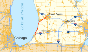
Interstate 196 (I-196) is an auxiliary Interstate Highway that runs for 80.594 miles (129.703 km) in the US state of Michigan. It is a state trunkline highway that links Benton Harbor, South Haven, Holland, and Grand Rapids together. In Kent, Ottawa, and Allegan counties, I-196 is known as the Gerald R. Ford Freeway, or simply the Ford Freeway, after the 38th President of the United States, Gerald Ford, who was raised in Grand Rapids and served Michigan in the House of Representatives. This name generally refers only to the section between Holland and Grand Rapids. I-196 changes direction; it is signed as a north–south highway from its southern terminus to the junction with US Highway 31 (US 31) just south of Holland, and as an east–west trunkline from this point to its eastern terminus at an interchange with I-96, its parent highway. There are currently three business routes related to the main freeway. There are two business loops (BL I-196) and one business spur (BS I-196) that serve South Haven, Holland and the Grand Rapids areas. Another business spur for Muskegon had been designated relative to the I-196 number.
The current freeway numbered I-196 is the second in the state to bear the number. Originally to be numbered as part of the I-94 corridor in the state, the Benton Harbor–Grand Rapids freeway was given the I-96 number in the 1950s while another Interstate between Muskegon and Grand Rapids was numbered I-196. That I-196 was built in the late 1950s and completed in the early 1960s. The first segment of the current I-196 was opened as I-96 near Benton Harbor in 1962. Michigan officials requested a change in 1963, which reversed the two numbers and the subsequent segments of freeway opened northward to Holland and from Grand Rapids westward under the current number. The gap between Holland and Grandville was filled in the 1970s, and a section of freeway that runs through downtown Grand Rapids was rebuilt as a wider freeway in 2010.
Route description
Like other state highways in Michigan, I-196 is maintained by the Michigan Department of Transportation (MDOT). In 2011, the department's traffic surveys showed that on average, 77,500 vehicles used the highway daily between Lane Avenue and US 131 in Grand Rapids and 12,778 vehicles did so each day north of the split with US 31 near Holland. These are the highest and lowest counts along the highway, respectively.[3] As an Interstate Highway, all of I-196 is listed on the National Highway System,[4] a network of roads important to the country's economy, defense, and mobility.[5] In addition, the highway has been named by the Michigan Legislature the Gerald R. Ford Freeway to honor the 38th President of the United States.[6] The original legislation from 1974 extended that name to the full length of the freeway, but when the various memorial highway names were re-codified in 2001, the name was not applied to the Berrien County segment.[7] From the junction with M-63 north to the split with US 31 except for the section that connects the ends of the South Haven business loop, the freeway is also a part of the Lake Michigan Circle Tour (LMCT), a tourist route that follows Lake Michigan.[8]
Benton Harbor to Holland
The freeway starts northeast of Benton Harbor at exit 34 on I-94 in Benton Charter Township in Berrien County. At the trumpet interchange, I-196 runs north from I-94 and passes to the west of the Point O'Woods Golf & Country Club. US 31 joins I-196 from the southwest and runs concurrently with I-196 as the freeway passes through farm fields in southwestern Michigan. The trunkline turns northwesterly near the Lake Michigan Hills Golf Course and crosses the Paw Paw River. Past the river, the freeway turns northeasterly and runs roughly parallel to the Lake Michigan shoreline several miles inland. At the community of Lake Michigan Beach, I-196/US 31 meets the northern terminus of M-63 at exit 7, and the LMCT joins the freeway for the first time. North of this interchange, the freeway parallels A-2, a county road that follows the Blue Star Highway, the former route of US 31.[8][9]
A bit further north, I-196/US 31 crosses into Van Buren County and assumes the Gerald R. Ford Freeway name. The inland side of the freeway is forested while the lakeward side is predominantly either forest or fields. As it approaches South Haven, the freeway passes near the Palisades Nuclear Generating Station and Van Buren State Park. North of the power plant and park, the freeway turns farther inland to bypass the city of South Haven. There is an interchange on the south side of town that provides access to Business Loop I-196 (BL I-196) and M-140. The freeway crosses over M-43 without an interchange and then intersects the other end of the business loop about two miles (3.2 km) later. It crosses the Black River near the Van Buren–Allegan county line.[8][9]
In Allegan County, I-196/US 31 passes a pair of golf courses and continues northward through farm fields. Near the community of Glenn, A-2 crosses over the freeway and runs parallel to it on the east. They trade places again when I-196/US 31 turns northeasterly on the south side of the twin cities of Saugatuck and Douglas. The freeway crosses over a section of Kalamazoo Lake, a wider section of the Kalamazoo River that flows between the two towns. A-2 crosses back to the eastern side of the freeway north of Saugatuck, and I-196/US 31 continues north-northeasterly toward Holland.[8][9]
Holland to Grand Rapids
On the south side of Holland, the two highways split apart; US 31 separates from I-196 at a partial interchange near the West Michigan Regional Airport (formerly the Tulip City Airport). At this interchange, northbound traffic may follow a left exit to continue on the BL I-196/US 31 freeway or continue along I-196 which turns more eastward; the LMCT departs I-196 at this point as well. Signage along I-196 changes after this interchange. Up to this point, it had been signed north–south, but from the US 31 split onward, the directions are now signed east–west. The freeway passes to the south side of the airport,[8][9] and it crosses a rail line owned by CSX Transportation and used by Amtrak's Pere Marquette train[10] before curving northeasterly through the interchange with M-40. The freeway crosses into Ottawa County south of the Macatawa River before meeting the other two interchanges for Holland, the second of which is the northern end of the business loop in Zeeland.[8][9]
Continuing past Zeeland, I-196 runs more east-northeasterly as it parallels M-121 (Chicago Drive). The freeway passes to the south side of Hudsonville and intersects A-37. About two miles (3.2 km) past Hudsonville, the trunkline has an interchange with M-6, a freeway that runs along the south side of the Grand Rapids area. Just past this interchange, the freeway crosses into Kent County at the Kenowa Avenue overpass. Now in the city of Grandville, I-196 turns northward to run parallel to the county line. The freeway has an interchange for 44th Street, which provides access to the RiverTown Crossings mall and other retail and restaurant establishments in the area. At exit 69, I-196 crosses Chicago Drive and the rail line and turns northeasterly next to Jenison, an unincorporated community opposite the Kent–Ottawa county line. The Ford Freeway name is now prominently used on the freeway signage as I-196 follows a section of the Grand River. Past the interchange for M-11 (28th Street), the freeway crosses into the suburb of Wyoming.[8][9]
In Wyoming, the freeway runs along the river, passing Millennium Park on the opposite banks in Walker and Hopewell Indian Mounds Park on the near banks. To the south of the freeway, the business spur for Wyoming and Grand Rapids departs to follow Chicago Drive near an industrial area. After the interchange for Market Avenue, I-196 crosses the Grand River and enters the city of Grand Rapids. The freeway meanders northward past the transmission antennas for radio stations WJRW and WFUR and around the west side of the John Ball Zoological Garden. The trunkline has an interchange with M-45 (Lake Michigan Drive) on the north side of the zoo before I-196 runs downhill turning eastward.[9][11]
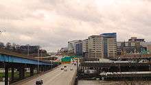
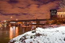
At the bottom of the hill, I-196 enters the urban core of Grand Rapids. The freeway runs eastward through residential neighborhoods on the city's west side as it approaches the interchange with US 131. This complex structure is adjacent to the Grand River north of the Gerald R. Ford Presidential Museum. The carriageways for I-196 run through the interchange on different levels, with the eastbound traffic carried down near river level and the westbound lanes above the criss-crossing carriageways of US 131's freeway. I-196 crosses the river on the opposite side of the interchange and both directions return to the same level. The freeway picks up an additional lane at this point as the median is replaced by a concrete barrier.[9][11]
As the freeway runs eastward, it passes the area of Grand Rapids known as the "Medical Mile", a district anchored by the Van Andel Institute, Helen DeVos Children's Hospital, a campus of the Michigan State University College of Human Medicine and the Butterworth Hospital campus of Spectrum Health. The Ford Freeway jogs slightly to the northeast as it crosses a line of the Grand Rapids Eastern Railroad[10] between College and Eastern avenues. It then passes to the south of the offices buildings that house the Kent County Health Department, the Sheriff's Department and the animal shelter. A little over a mile and a quarter (2.0 km) east of those offices, I-196 meets its parent highway, I-96 on the east side of the city. This interchange marks the eastern terminus of the Ford Freeway and I-196.[9][11]
History
Previous designation
| |
|---|---|
| Location: | Muskegon–Grand Rapids |
| Length: | 37.073 mi[1] (59.663 km) |
| Existed: | 1959[12]–1963[2] |
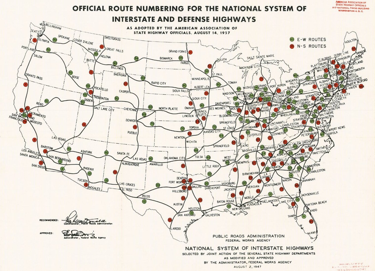
In the first tentative Interstate numbering plans,[13] the freeways in Michigan now numbered I-96 and I-196 were supposed to be part of the I-94 corridor, and the freeway between Muskegon and Grand Rapids was to be I-94N.[14] Later, the initial approvals by the federal government routed I-96 from Benton Harbor north to Grand Rapids and then east to Detroit, and I-196 was the spur route from Grand Rapids to Muskegon.[lower-alpha 1][16] The first segment of freeway built was a relocated section of US 16 near Coopersville and Marne. The freeway opened at the end of 1957 or in early 1958,[17][18] and the first markers for I-196 were erected in 1959.[12] The full Grand Rapids–Muskegon I-196 freeway was completed and opened to traffic in December 1962, connecting to an I-96 freeway that led east toward Lansing; the US 16 corridor was a continuous freeway with two different Interstate designations. Before the Grand Rapids–Benton Harbor segment was completed, the Michigan State Highway Department (MSHD), predecessor to the modern MDOT, petitioned federal highway officials to switch the Interstate designations west of Grand Rapids.[19] Permission for this switch was granted in 1963.[2] Consideration was also made to name the Grand Rapids–Benton Harbor freeway I-67.[15] The previously completed I-196 was redesignated as an extension of I-96, and the completed freeway segments southwest of Grand Rapids were redesignated I-196; I-67 was rejected by the American Association of State Highway Officials.[2]
Current designation
In 1962, a section of freeway along US 31 was opened between I-94 and the Berrien–Van Buren county line. This section was originally designated as part of I-96/US 31.[20][21] After the designation switch in 1963,[19] an additional 35 miles (56 km) were opened from the northern end of I-196 near Benton Harbon to Holland as I-196.[22] An additional section of freeway was opened between Grandville through downtown Grand Rapids to meet I-96 at the end of 1964. M-21 was moved to the freeway from its previous surface-street routing.[23] The final link in the freeway was completed in November 1974 along the Holland–Grandville segment, completing I-196 for a second time.[24] At the same time, M-21 was removed from the freeway, truncating that highway designation to end in Grand Rapids.[25][26]
In 2009, access to Jenison was improved by the addition of a partial interchange with Baldwin Street.[27] The section through downtown Grand Rapids east of the Grand River was rebuilt during 2010 in a project MDOT dubbed the "Fix on I-196". The project added a third travel lane in each direction with weave-merge lanes between interchanges and rebuilt several of the overpasses in the area.[28] In 2016, the sections of I-196 that run concurrently with US 31 north of the M-63 interchange, except between the ends of the business loop at South Haven were designated as part of the West Michigan Pike Pure Michigan Byway.[29]
Exit list
| County | Location | mi[1] | km | Exit | Destinations | Notes |
|---|---|---|---|---|---|---|
| Berrien | Benton Charter Township | 0.000 | 0.000 | — | Southbound exit and northbound entrance; southern end of US 31 concurrency; exit 34 on I-94 | |
| 1.051 | 1.691 | 1 | Red Arrow Highway | |||
| Hagar Township | 3.677 | 5.918 | 4 | Coloma, Riverside | ||
| 6.751 | 10.865 | 7 | Southern end of LMCT concurrency | |||
| Van Buren | Covert Township | 12.624 | 20.316 | 13 | Covert | |
| South Haven Township | 17.572 | 28.279 | 18 | Northern terminus of M-140, southern terminus of BL I-196; northbound signage omits Watervliet; signed only as M-140 – Watervliet southbound | ||
| South Haven | 20.383 | 32.803 | 20 | Signed only as Phoenix Street northbound; northern terminus of BL I-196; signed as exits 20A (east) and 20B (west) northbound | ||
| Allegan | Casco Township | 21.966 | 35.351 | 22 | North Shore Drive | |
| 26.309 | 42.340 | 26 | 109th Avenue – Pullman | |||
| Ganges Township | 29.570 | 47.588 | 30 | Ganges signed northbound only | ||
| Ganges–Saugatuck township line | 33.922 | 54.592 | 34 | Western terminus of M-89 | ||
| Saugatuck Township | 36.111 | 58.115 | 36 | Saugatuck and Douglas signed northbound only; Ganges signed southbound only | ||
| Laketown Township | 40.925 | 65.862 | 41 | Blue Star Highway signed northbound only; Saugatuck and Douglas signed southbound only | ||
| 44.495 | 71.608 | 44 | Northbound exit and southbound entrance; northern end of US 31 and LMCT concurrencies; I-196 signage changes from north–south to east–west | |||
| Holland | 48.600 | 78.214 | 49 | |||
| Ottawa | Holland Township | 52.230 | 84.056 | 52 | Adams Street, 16th Street | |
| Zeeland Township | 55.485 | 89.294 | 55 | Eastern terminus of BL I-196; eastbound signage omits BL I-196 and Holland; westbound signage omits Byron Road | ||
| Hudsonville | 62.217 | 100.129 | 62 | 32nd Avenue – Hudsonville | ||
| Georgetown Township | 64.174– 64.886 | 103.278– 104.424 | 64 | Western terminus of M-6 | ||
| Kent | Grandville | 67.346 | 108.383 | 67 | 44th Street, Rivertown Parkway | |
| 68.748 | 110.639 | 69 | Signed as exits 69A (east) and 69B (west) westbound; eastern terminus of M-121 | |||
| 68.940 | 110.948 | 69C | Baldwin Street | Westbound exit and eastbound entrance; exit opened November 2009[27] | ||
| 69.747 | 112.247 | 70 | Signed as exits 70A (east, 28th Street, Wyoming) and 70B (west, Wilson Avenue, Walker) eastbound; signed westbound as only Grandville and Walker | |||
| Wyoming | 71.716 | 115.416 | 72 | Eastbound exit and westbound entrance from westbound Chicago Drive only | ||
| Grand Rapids | 73.406 | 118.136 | 73 | Market Avenue | ||
| 74.898 | 120.537 | 75 | No access from westbound Lake Michigan Drive to eastbound I-196 or westbound I-196 to eastbound Lake Michigan Drive; eastern terminus of M-45 | |||
| 75.774 | 121.946 | 76 | Lane Avenue | |||
| 76.515– 76.567 | 123.139– 123.223 | 77 | Signed as exits 77A (north) and 77B (south); southern terminus of unsigned I-296 | |||
| 76.932 | 123.810 | 77C | Ottawa Avenue – Downtown Grand Rapids | |||
| 77.601 | 124.887 | 78 | College Avenue | |||
| 78.491 | 126.319 | 79 | Fuller Avenue | |||
| 80.594 | 129.703 | — | Eastbound exit and westbound entrance; exit 37 on I-96 | |||
1.000 mi = 1.609 km; 1.000 km = 0.621 mi
| ||||||
Business routes
There are currently two business loops (BL I-196) and one business spur (BS I-196) along I-196. A BS I-196 in Muskegon was designated along what is now Bus. US 31 before the Muskegon–Grand Rapids freeway was redesignated I-96.[19][21]
South Haven
| |
|---|---|
| Location: | South Haven |
| Length: | 3.572 mi[1] (5.749 km) |
| Existed: | 1963[21][30]–present |
| Tourist routes: | |
Business Loop I-196 (BL I-196) is a loop that runs in South Haven for 3.572 miles (5.749 km). The loop begins at exit 18 on I-196/US 31 and runs due north along La Grange Street. It then turns onto Phillips Street and merges into Broadway Street. BL I-196 follows Phoenix Street eastward where the trunkline ends at exit 20 on I-196. The entire length is a part of the LMCT.[8] A bypass of downtown was built during World War II; the former route of US 31 through downtown was designated Bus. US 31 at that time.[31][32] When I-196 was built outside of South Haven in 1963, the former US 31 bypass was redesignated BL I-196.[21][30] In 1972, the loop was shifted to follow the pre-war routing through downtown.[33][34] In 2016, all of the business loop was designated as part of the West Michigan Pike Pure Michigan Byway.[29]
Major intersections
The entire highway is in Van Buren County.
| Location | mi[1] | km | Destinations | Notes | |
|---|---|---|---|---|---|
| South Haven Township | 0.000 | 0.000 | Exit 18 on I-196; northern terminus of M-140 | ||
| 1.189 | 1.914 | ||||
| South Haven | 2.125 | 3.420 | Western terminus of M-43 | ||
| 3.273 | 5.267 | ||||
| 3.572 | 5.749 | Phoenix Road | Exit 20 on I-196; roadway continues eastward as Phoenix Road | ||
| 1.000 mi = 1.609 km; 1.000 km = 0.621 mi | |||||
Holland
| |
|---|---|
| Location: | Holland–Zeeland |
| Length: | 11.649 mi[1] (18.747 km) |
| Existed: | 1974[25][26]–present |
| Tourist routes: | |
Business Loop I-196 (BL I-196) is a loop that runs for 11.649 miles (18.747 km) in Holland and Zeeland. The loop starts at a connection with I-196/US 31 at exit 44 and continues concurrently along the freeway into Holland. BL I-196/US 31 has an interchange for A-2 (Blue Star Highway) and Washington Avenue before the freeway ends in the southern reaches of Holland. The trunkline then runs as a divided highway northward, bypassing downtown Holland to the east and intersecting M-40. Northeast of downtown, BL I-196 leaves US 31 and the LMCT at an interchange to follow an expressway along the route of Chicago Drive. The loop follows this expressway through Zeeland and back out to I-196 at exit 55.[8]
The loop was created in 1974 when I-196 was completed south of the city of Holland. From that point, the old route of M-21 inside the cities to US 31 was redesignated as a business loop of I-196 with the state taking control of Washington Avenue to the downtown area. Then from downtown looping back up to Chicago Drive, the business loop used the old M-21.[25][26] Along Washington Avenue and Chicago Drive between junctions with US 31, the highway bore a concurrent Bus. US 31 designation. The concurrent trunkline inside the downtown area of Holland was transferred to the City of Holland in 2005, and BL I-196 was rerouted to follow US 31.[35][36] In 2016, the section of the business loop that runs concurrently with US 31 was designated as part of the West Michigan Pike Pure Michigan Byway.[29]
Major intersections
All exits are unnumbered.
| County | Location | mi[1] | km | Destinations | Notes |
|---|---|---|---|---|---|
| Allegan | Laketown Township | 0.000 | 0.000 | Southern end of US 31/LMCT concurrency; southbound exit and northbound entrance only; exit 44 on I-196/US 31 | |
| Holland | 2.013 | 3.240 | Northern terminus of A-2; former southern terminus of Bus. US 31 | ||
| 2.882 | 4.638 | Northern end of freeway | |||
| 3.413 | 5.493 | Northern terminus of M-40 | |||
| Ottawa | 6.192 | 9.965 | Northern end of US 31/LMCT concurrency; partial cloverleaf interchange | ||
| Zeeland | 10.952 | 17.626 | Western terminus of M-121 | ||
| 11.649 | 18.747 | Exit 55 on I-196 | |||
1.000 mi = 1.609 km; 1.000 km = 0.621 mi
| |||||
Grand Rapids
| |
|---|---|
| Location: | Wyoming–Grand Rapids |
| Length: | 3.631 mi[1] (5.844 km) |
| Existed: | 1974[37][38]–present |
Business Spur I-196 (BS I-196) is a spur that serves the Godfrey–Lee area of Wyoming and the Roosevelt Park neighborhood of Grand Rapids. It starts at the partial interchange for exit 72 on I-196 and then moves onto the surface street Chicago Drive for the majority of the distance in Wyoming, running through an industrial area. After about a mile (1.6 km), the highway runs through residential areas. Upon crossing the Grand Rapids city limits, it turns northerly onto Grandville Avenue where it runs until turning onto Franklin Street. The spur then ends at the interchange with US 131. Its total length is 3.631 miles (5.844 km). It can only be accessed from eastbound I-196 on the western end.[11]
In 1953, the state highway department completed enough of the Grand Rapids beltline to reroute M-21 to it. The former routing of M-21 was then redesignated Bus. M-21.[39][40] With the completion of I-196 from Holland to Grand Rapids in 1974, the highway was truncated to its current format and renamed BS I-196.[37][38]
Major intersections
The entire highway is in Kent County.
| Location | mi[1] | km | Destinations | Notes | |
|---|---|---|---|---|---|
| Wyoming | 0.000– 0.231 | 0.000– 0.372 | Chicago Drive | Westbound exit to, and eastbound entrance from, exit 72 on I-196; roadway continues westerly as Chicago Drive | |
| 2.433 | 3.916 | Clyde Park Avenue | Eastern end of Chicago Drive and southern end of Grandville Avenue sections of BS I-196 | ||
| Grand Rapids | 3.631 | 5.844 | Exit 83B on US 131 | ||
| 1.000 mi = 1.609 km; 1.000 km = 0.621 mi | |||||
See also
 Michigan Highways portal
Notes
References
- 1 2 3 4 5 6 7 8 9 Michigan Department of Transportation & Michigan Center for Shared Solutions and Technology Partnerships (2009). MDOT Physical Reference Finder Application (Map). Michigan Department of Transportation. Retrieved July 11, 2012.
- 1 2 3 4 "New Numbers Seen for Road". Holland Evening Sentinel. October 23, 1963. p. 4. OCLC 13440201.
- ↑ Bureau of Transportation Planning (2008). "Traffic Monitoring Information System". Michigan Department of Transportation. Retrieved June 30, 2012.
- ↑ Michigan Department of Transportation (April 23, 2006). National Highway System, Michigan (PDF) (Map). Scale not given. Lansing: Michigan Department of Transportation. Retrieved October 7, 2008.
- ↑ Natzke, Stefan; Neathery, Mike & Adderley, Kevin (June 26, 2013). "What is the National Highway System?". National Highway System. Federal Highway Administration. Retrieved July 1, 2013.
- ↑ Shawver, Tom (July–August 2000). "The Inside Story: The Ford Freeway Funnies" (PDF). Michigan History. Vol. 86 no. 4. Lansing, MI: Michigan Department of State. pp. 8–9. ISSN 0026-2196. OCLC 220951644. Archived from the original (PDF) on November 26, 2003. Retrieved July 11, 2012.
- ↑ Barnett, LeRoy (2004). A Drive Down Memory Lane: The Named State and Federal Highways of Michigan. Allegan Forest, MI: Priscilla Press. pp. 89–90. ISBN 1-886167-24-9. OCLC 57425393.
- 1 2 3 4 5 6 7 8 9 Michigan Department of Transportation (2012). Pure Michigan: State Transportation Map (Map). c. 1:975,000. Lansing: Michigan Department of Transportation. §§ L9–N4. OCLC 42778335, 794857350.
- 1 2 3 4 5 6 7 8 9 Google (July 11, 2012). "Overview Map of Interstate 196" (Map). Google Maps. Google. Retrieved July 11, 2012.
- 1 2 Michigan Department of Transportation (January 2011). Michigan's Railroad System (PDF) (Map). Scale not given. Michigan Department of Transportation. Archived from the original (PDF) on April 9, 2011. Retrieved February 1, 2011.
- 1 2 3 4 Michigan Department of Transportation (2012). Pure Michigan: State Transportation Map (Map). c. 1:221,760. Lansing: Michigan Department of Transportation. Grand Rapids inset. OCLC 42778335, 794857350.
- 1 2 3 "Michigan Delays Road Number System". Toledo Blade. Associated Press. June 4, 1959. p. 11. OCLC 12962717. Retrieved November 21, 2010 – via Google News.
- 1 2 Lewis, Tom (1997). Divided Highways: Building the Interstate Highways, Transforming American Life. New York: Viking. pp. 120–1, 136–7. ISBN 0-670-86627-X. OCLC 36942490.
- ↑ Public Roads Administration & American Association of State Highway Officials (August 14, 1957). Official Route Numbering for the National System of Interstate and Defense Highways (Map). Scale not given. Washington, DC: Public Roads Administration. Retrieved September 4, 2010.
- 1 2 Michigan State Highway Department (April 25, 1958). "Recommended Interstate Route Numbering for Michigan". Michigan State Highway Department. Archived from the original on August 5, 2004. Retrieved September 4, 2010.
- ↑ Public Roads Administration (c. 1963). National System of Interstate and Defense Highways (Map). Scale not given. Washington, DC: Bureau of Public Roads. Retrieved September 4, 2010 – via Wikimedia Commons.
- ↑ Michigan State Highway Department (October 1, 1957). Official Highway Map (Map). [c. 1:918,720]. Lansing: Michigan State Highway Department. § L8. OCLC 12701120, 367386492.
- ↑ Michigan State Highway Department (1958). Official Highway Map (Map). [c. 1:918,720]. Lansing: Michigan State Highway Department. § L8. OCLC 12701120, 51856742. (Includes all changes through July 1, 1958)
- 1 2 3 "Would Shift Route Number: Mackie Seeks Int. 96 Designation for Grand Rapids–Muskegon Stretch". The Grand Rapids Press. May 1, 1963. p. 32. OCLC 9975013.
- ↑ Michigan State Highway Department (1962). Official Highway Map (Map). [c. 1:918,720]. Lansing: Michigan State Highway Department. §§ K7–L8, M7. OCLC 12701120, 173191490.
- 1 2 3 4 Michigan State Highway Department (1963). Official Highway Map (Map). [c. 1:918,720]. Lansing: Michigan State Highway Department. §§ M7–L8. OCLC 12701120.
- ↑ Mackie, John C. (December 26, 1963). "John Mackie Lists Many Achievements During 1963". Holland Evening Sentinel. p. 22. OCLC 13440201.
- ↑ Michigan State Highway Department (1965). Official Highway Map (Map). [c. 1:918,720]. Lansing: Michigan State Highway Department. § L8. OCLC 12701120.
- ↑ "Ford Will Miss I-196 Dedication". The News-Palladium. Benton Harbor, MI. Associated Press. November 30, 1974. p. 10. OCLC 10117334. Retrieved June 28, 2013 – via NewspaperArchive.com. (subscription required (help)).
- 1 2 3 Michigan Department of State Highways and Transportation (1974). Michigan, Great Lake State: Official Transportation Map (Map). c. 1:918,720. Lansing: Michigan Department of State Highways and Transportation. § L8. OCLC 12701177, 83138602.
- 1 2 3 Michigan Department of State Highways and Transportation (1975). Michigan, Great Lake State: Official Transportation Map (Map). c. 1:918,720. Lansing: Michigan Department of State Highways and Transportation. § L8. OCLC 12701177, 320798754.
- 1 2 King, Kyla (November 13, 2009). "New Baldwin, I-196 Interchange Set to Open Tonight". The Grand Rapids Press. Retrieved September 17, 2014.
- ↑ King, Kyla (November 19, 2010). "'Fix on I-196' Ribbon Cutting Livened up by WGRD 'Free Beer and Hot Wings' Radio Station Stunt". The Grand Rapids Press. OCLC 9975013. Archived from the original on June 15, 2013. Retrieved July 22, 2012.
- 1 2 3 Witt, Jeremy (July 22, 2016). "State's Newest Michigan Byway to be Designated on Monday". West Michigan Tourist Association. Retrieved July 23, 2016.
- 1 2 Michigan State Highway Department (1964). Official Highway Map (Map). [c. 1:918,720]. Lansing: Michigan State Highway Department. §§ M7–L8. OCLC 12701120, 81213707.
- ↑ Michigan State Highway Department & Rand McNally (June 1, 1942). Official Michigan Highway Map (Map) (Summer ed.). [c. 1:850,000]. Lansing: Michigan State Highway Department. § M8. OCLC 12701143.
- ↑ Michigan State Highway Department (October 1, 1945). Official Highway Map of Michigan (Map). [c. 1:918,720]. Lansing: Michigan State Highway Department. § M8. OCLC 554645076.
- ↑ Michigan Department of State Highways (1972). Michigan, Great Lake State: Official Highway Map (Map). c. 1:918,720. Lansing: Michigan Department of State Highways. § M8. OCLC 12701120.
- ↑ Michigan Department of State Highways (1973). Michigan, Great Lake State: Official Highway Map (Map). c. 1:918,720. Lansing: Michigan Department of State Highways. § M8. OCLC 12701120, 81679137.
- ↑ Michigan Department of Transportation (2005). Michigan, One Hundred Years of Michigan Transportation: Official Department of Transportation Map (Map). c. 1:975,000. Lansing: Michigan Department of Transportation. § L8. OCLC 42778335, 71041619.
- ↑ Michigan Department of Transportation (2006). Michigan, A State for All Seasons: Official Department of Transportation Map (Map). c. 1:975,000. Lansing: Michigan Department of Transportation. § L8. OCLC 42778335.
- 1 2 Michigan Department of State Highways and Transportation (1974). Michigan, Great Lake State: Official Transportation Map (Map). c. 1:190,080. Lansing: Michigan Department of State Highways and Transportation. Grand Rapids inset. OCLC 12701177, 83138602.
- 1 2 Michigan Department of State Highways and Transportation (1975). Michigan, Great Lake State: Official Transportation Map (Map). c. 1:190,080. Lansing: Michigan Department of State Highways and Transportation. Grand Rapids inset. OCLC 12701177, 320798754.
- ↑ Michigan State Highway Department (April 15, 1953). Official Highway Map (Map). Scale not given. Lansing: Michigan State Highway Department. Grand Rapids inset. OCLC 12701120.
- ↑ Michigan State Highway Department (October 1, 1953). Official Highway Map (Map). Scale not given. Lansing: Michigan State Highway Department. Grand Rapids inset. OCLC 12701120.
External links
| Wikimedia Commons has media related to Interstate 196. |
- Mainline
 Geographic data related to I-196 at OpenStreetMap
- I-196 at Michigan Highways
- I-196 at Michigan Highway Ends
- I-196 Michigan at AARoad's Interstate Guide
- 3-digit Interstates from I-96 at Kurumi.com
- Business routes
- Geographic data related to BL I-196 in South Haven at OpenStreetMap
- BL I-196 in South Haven at Michigan Highways
- Geographic data related to BL I-196 in Holland at OpenStreetMap
- BL I-196 in Holland at Michigan Highways
- Geographic data related to BS I-196 in Grand Rapids at OpenStreetMap
- BS I-196 in Grand Rapids at Michigan Highways
- BS I-196 Grand Rapids at Michigan Highway Ends
1Unsigned | ||