Interstate 182
| ||||
|---|---|---|---|---|
|
I-182 highlighted in red. | ||||
| Route information | ||||
| Defined by RCW 47.17.372 | ||||
| Maintained by WSDOT | ||||
| Length: | 15.19 mi[1][2] (24.45 km) | |||
| Existed: | June 23, 1969[3] – present | |||
| History: | Completed in 1986 | |||
| Major junctions | ||||
| West end: |
| |||
|
| ||||
| East end: |
| |||
| Location | ||||
| Counties: | Benton, Franklin | |||
| Highway system | ||||
| ||||
.svg.png)
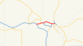
Interstate 182 (I-182) is an east–west auxiliary Interstate Highway in the U.S. state of Washington. The state highway is an Interstate route, traveling around the city of Kennewick, the largest of the three Tri-Cities in Eastern Washington. I-182 passes through the cities of Richland and Pasco, located in Benton and Franklin counties, respectively. The four-lane freeway, which is concurrent with U.S. Route 12 (US 12) for its entire 15-mile-long (24 km) length, begins at an interchange with I-82 in the Horse Heaven Hills and runs through Richland, becoming concurrent with State Route 240 (SR 240). I-182 and US 12 cross over the Columbia River into Pasco on the Interstate 182 Bridge and become concurrent with US 395 before the former designation ends abruptly.
Route description
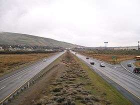
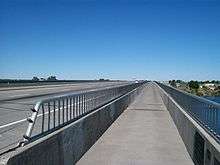
I-182 begins at Goose Gap, located between Badger Mountain and Candy Mountain in the Horse Heaven Hills,[4] at a trumpet interchange with I-82 and US 12 in unincorporated Benton County.[5] The four-lane freeway carries I-182 and US 12 concurrently northeast into Richland, where it intersects Queensgate Drive in a partial cloverleaf interchange.[6] The highway continues east across the Yakima River to a trumpet interchange with SR 240, forming a short concurrency with SR 240.[7] The concurrency ends at the following junction, a cloverstack interchange with George Washington Way, where I-182 and US 12 split off from SR 240, which continues southeast into Kennewick along the Columbia River.[8] The freeway continues northwest across the Columbia River on the Interstate 182 Bridge, also known as the Lee-Volpentest Bridges, which carry six lanes of I-182 on twin 1,500-foot-long (460 m) spans into Pasco in Franklin County.[9][10][11]
I-182 enters Pasco and turns 90 degrees southeast towards the city center after intersections with Broadmoor Boulevard and Road 68 at Gesa Stadium.[12][13] The freeway intersects US 395 in a trumpet interchange, beginning a third concurrency, and 20th Avenue in a partial cloverleaf interchange near Columbia Basin College and the Tri-Cities Airport, utilizing an eastbound collector-distributor lane.[14] I-182 continues east, forming the northern boundary of downtown Pasco, intersecting 4th Avenue before crossing over a BNSF-owned railyard.[15][16] The freeway reaches a cloverleaf interchange with SR 397, where US 395 splits off to travel north towards Spokane.[17] I-182 ends southeast of the interchange, while the roadway continues southeastward towards Burbank and Walla Walla as US 12.[10][11]
I-182 is defined by the Washington State Legislature as SR 182, part of the Revised Code of Washington as §47.17.020.[18] As a component of the Interstate Highway System,[1][2] the highway is listed as part of the National Highway System for its entire length,[19] classifying it as important to the national economy, defense, and mobility.[20] The Washington State Department of Transportation (WSDOT) maintains the freeway and designates the corridor as a Highway of Statewide Significance,[21] which includes highways that connect major communities in the state of Washington.[22] WSDOT also conducts an annual series of surveys on its highways in the state to measure traffic volume, which is expressed in terms of average annual daily traffic (AADT), a measure of traffic volume for any average day of the year. WSDOT calculated that the busiest section of I-182 is between its interchange with SR 240 and the Interstate 182 Bridge in Richland, where approximately 60,000 vehicles used the freeway on average each day in 2013; in contrast, the lowest traffic level on I-182 was 8,900 vehicles at its western terminus with I-82.[23]
History
As part of Washington's first connected state highway system, the Washington State Legislature designated the Inland Empire Highway between Ellensburg and Laurier in 1913.[24][25] The State Highway Board selected a route that would connect the main cities of Eastern Washington and the Inland Empire, which were Ellensburg, Yakima, the Tri Cities, Colfax, and Spokane.[26][27] In 1923, by which time the entire road had been improved,[28] the highway became State Road 3 (Primary State Highway 3 after 1937), but retained its name.[29] By that time, all of the route of Interstate 182 became a part of US 410 and US 395; both were established in 1926.[30][31][32] When I-82 was approved in 1956, the Tri-Cities wanted an Interstate, since Interstate 82 bypassed the cities. Interstate 182 was the solution and created a connection to the Tri-Cities. Legally, I-182 is defined by the Revised Code of Washington § 47.17.372.
Exit list
| County | Location | mi[1] | km | Exit | Destinations | Notes |
|---|---|---|---|---|---|---|
| Benton | | 0.00 | 0.00 | Western terminus, eastbound entrance and westbound exit, west end of US 12 overlap; I-82 exit 102 | ||
| Richland | 2.93 | 4.72 | 3 | Queensgate Drive | Signed as westbound exits 3A and 3B | |
| 3.83 | 6.16 | 4 | West end of SR 240 overlap | |||
| 4.95 | 7.97 | 5 | Signed as exits 5A and 5B, east end of SR 240 overlap | |||
| Columbia River | 5.87– 6.25 | 9.45– 10.06 | Interstate 182 Bridge | |||
| Franklin | Pasco | 7.31 | 11.76 | 7 | Broadmoor Boulevard | |
| 9.33 | 15.02 | 9 | Road 68 | |||
| 12.25 | 19.71 | 12A | West end of US 395 overlap | |||
| 12.69 | 20.42 | 12B | North 20th Avenue – Columbia Basin College | |||
| 13.78 | 22.18 | 13 | North 4th Avenue – City Center | |||
| 14.37 | 23.13 | 14 | Signed as exits 14A and 14B, east end of US 395 overlap | |||
| 15.19 | 24.45 | Eastern terminus, east end of US 12 overlap | ||||
1.000 mi = 1.609 km; 1.000 km = 0.621 mi
| ||||||
References
- 1 2 3 Staff (2013). "State Highway Log: Planning Report 2013, SR 2 to SR 971" (PDF). Washington State Department of Transportation. pp. 1195–1200. Retrieved April 10, 2014.
- 1 2 Staff (October 31, 2002). "Table 2: Auxiliary Routes of the Dwight D. Eisenhower National System Of Interstate and Defense Highways". Federal Highway Administration. Retrieved April 23, 2013.
- ↑ Johnson, A.E. (June 23, 1969). "U.S. Route Numbering Subcommittee Agenda Showing Action Taken by the Executive Committee" (PDF) (Report). Grand Teton National Park, WY: American Association of State Highway Officials. p. 12. Retrieved August 3, 2014 – via Wikimedia Commons.
- ↑ "Feature Detail Report for: Goose Gap". Geographic Names Information System. United States Geological Survey. September 10, 1979. Retrieved April 23, 2013.
- ↑ "SR 82 - Exit 102: Junction SR 182" (PDF). Washington State Department of Transportation. June 23, 2007. Retrieved April 23, 2013.
- ↑ "SR 182 - Exit 3: Junction Queensgate Drive" (PDF). Washington State Department of Transportation. January 12, 2007. Retrieved April 23, 2013.
- ↑ "SR 182 - Exit 4: Junction SR 240" (PDF). Washington State Department of Transportation. October 18, 2010. Retrieved April 23, 2013.
- ↑ "SR 182 - Exit 5: Junction SR 240/George Washington Way" (PDF). Washington State Department of Transportation. December 9, 2006. Retrieved April 23, 2013.
- ↑ Staff (October 2011). "Bridge List M23-9.05" (PDF). Washington State Department of Transportation. pp. 275–277. Retrieved April 23, 2013.
- 1 2 Google (August 22, 2008). "Interstate 182" (Map). Google Maps. Google. Retrieved August 22, 2008.
- 1 2 Washington State Highways, 2011–2012 (PDF) (Map). 1:842,000. Washington State Department of Transportation. 2011. Retrieved April 23, 2013.
- ↑ "SR 182 - Exit 7: Junction Broadmoor Boulevard/Road 100" (PDF). Washington State Department of Transportation. January 25, 2010. Retrieved April 23, 2013.
- ↑ "SR 182 - Exit 9: Junction Road 68" (PDF). Washington State Department of Transportation. September 17, 2007. Retrieved April 23, 2013.
- ↑ "SR 182 - Exit 12: Junction SR 395/N 20th Avenue" (PDF). Washington State Department of Transportation. October 15, 2006. Retrieved April 23, 2013.
- ↑ "SR 182 - Exit 13: Junction 4th Avenue" (PDF). Washington State Department of Transportation. November 18, 1992. Retrieved April 23, 2013.
- ↑ 2011 Washington State Rail System (PDF) (Map). Washington State Department of Transportation. January 2012. Retrieved April 23, 2013.
- ↑ "SR 182 - Exit 14: Junction SR 395/SR 397" (PDF). Washington State Department of Transportation. March 1, 2011. Retrieved April 23, 2013.
- ↑ "47.17.372: State route No. 182". Revised Code of Washington. Washington State Legislature. 1979 [1971]. Retrieved August 10, 2008.
- ↑ National Highway System: Kennewick--Pasco, WA (PDF) (Map). Federal Highway Administration. October 1, 2012. Retrieved April 23, 2013.
- ↑ "What is the National Highway System?". Federal Highway Administration. September 26, 2012. Retrieved April 23, 2013.
- ↑ "Transportation Commission List of Highways of Statewide Significance" (PDF). Washington State Transportation Commission. July 26, 2009. Retrieved April 23, 2013.
- ↑ Lorenzo, Judy. "Highways of Statewide Significance". Washington State Department of Transportation. Retrieved April 23, 2013.
- ↑ Staff (2012). "2012 Annual Traffic Report" (PDF). Washington State Department of Transportation. pp. 153–154. Retrieved April 10, 2014.
- ↑ Washington State Legislature (1913). "An act relating to public highways, classifying the same and naming and fixing the routes of certain state roads.". Session Laws of the State of Washington. Olympia, WA: State of Washington. 1913 chapter 65, p. 221.: "A highway connecting with the Sunset Highway at or in the vicinity of the city of Ellensburg; thence by way of North Yakima, Kennewick, Pasco, Walla Walla, Dayton, crossing the Snake River at either Almota or Penawawa, Colfax, Rosalia, Spokane, Deer Park, Loon Lake, Colville, to the international line at boundary, which shall be known as the Inland Empire Highway."
- ↑ Washington State Legislature (1913) [1913]. "65". Session Laws of the State of Washington. Session Laws of the State of Washington (1913 ed.). Olympia, Washington: Washington State Legislature. p. 221. Retrieved 2008-08-10.
- ↑ Road Map of Washington Showing Main Traveled Roads (Map). State Highway Board. 1912. Retrieved 2008-08-26.
- ↑ Map of Washington State Highways Authorized by Legislative Acts of 1913 (with 1915 changes marked) (Map). State Highway Board. Retrieved 2008-08-26.
- ↑ Official 1923 Auto Trails Map, District No. 14: Washington, Oregon, Northern California, Western Idaho (Map). Rand McNally. Retrieved 2008-08-26.
- ↑ Washington State Legislature (1923). "An act relating to, classifying, naming and fixing the routes of certain state highways, amending Section 6796, and repealing Sections 6791, 6792, 6793, 6794, 6795, 6797, 6798, 6799, 6800, 6801, 6802, 6803, 6804, 6805, 6806, 6808, 6809, 6811, 6812, 6813 and 6816 of Remington's Compiled Statutes.". Session Laws of the State of Washington. Olympia, WA: State of Washington. 1923 chapter 185, p. 627-628.: "A primary state highway, to be known as State Road No. 3, or the Inland Empire Highway, is established as follows: Beginning at the international boundary line at Laurier in Ferry County; thence by the most feasible route in a southerly direction through Colville, Spokane, Colfax, Dayton to Walla Walla; thence in a northwesterly direction through the cities of Wallula, Pasco, Sunnyside, Yakima, Ellensburg, to a junction with the Sunset Highway at or near Virden in Kittitas County; also from a junction at Dodge in Garfield County; thence in an easterly direction through the cities of Pomeroy and Clarkston; thence in a southerly direction to Asotin in Asotin County; also from a junction at Wallula; thence in a southwesterly direction to the Oregon state line; also from a junction at Walla Walla in a southerly direction to the Oregon State line."
- ↑ Bureau of Public Roads & American Association of State Highway Officials (November 11, 1926). United States System of Highways Adopted for Uniform Marking by the American Association of State Highway Officials (Map). 1:7,000,000. Washington, DC: U.S. Geological Survey. OCLC 32889555. Retrieved November 7, 2013 – via University of North Texas Libraries.
- ↑ Highway Map: State of Washington (Map). Department of Highways. 1933-04-01. Retrieved 2008-08-26.
- ↑ Rand McNally (1939). Highways of the State of Washington (Map). Department of Highways. Retrieved 2008-08-26.
External links
 Media related to Category:Interstate 182 at Wikimedia Commons
- I-182 at Highways of Washington State
- I-182 at AARoads