Inter-Entity Boundary Line
The Inter-Entity Boundary Line (Bosnian: Međuentitetska linija, Serbian: Међуентитеска линија), commonly abbreviated IEBL, divides Bosnia and Herzegovina into two entities, the Republika Srpska and the Federation of Bosnia and Herzegovina. The total length of the Inter-Entity Boundary Line is 1,080 km (670 miles). Along the IEBL is the 2 km Zone of Separation, which stretch toward both entities, making the Zone 4 km wide in total.[1]
The IEBL essentially runs along the military front lines as they were at the end of the Bosnian War with some major adjustments (most importantly in the western part of the country, and in and around Sarajevo), made at the Dayton peace conference.
The present political divisions of Bosnia and Herzegovina were agreed upon as part the constitution that makes up Annex 4 of the General Framework Agreement for Peace concluded at the Dayton peace conference in November 1995, and subsequently signed in Paris on December 14, 1995. A key component of this was the delineation of the Inter-Entity Boundary Line, to which many of the tasks listed in the other Annexes referred. In particular the IEBL affected the tasks of the Military Annexes; such as the initial (immediate) Separation of Forces, the creation of an initial Zone of Separation, the Transfer of Areas between the Entities and the Removal of Forces to containment areas.
Dayton marked the first occasion when three-dimensional satellite image technology and digital cartography was used to determine and delineate boundaries in an official treaty.[2] Due to the speed and intensity of the negotiations (especially towards the end), a series of Inter-Entity Boundary Line commissions still needed to be held over the first 6 months of the NATO-led Implementation Force IFOR operation to iron out the remaining details of some of the boundaries (especially within Sarajevo). Over 40 changes to the Inter-Entity Boundary Line were negotiated by the parties in meetings facilitated by the Chief of Staff HQ ARRC, Major General Michael Willcocks. These were signed off by IFOR Commander Admiral Leighton W. Smith, Jr. in July 1996.
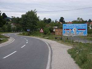
The IEBL between Republika Srpska and the Federation of Bosnia and Herzegovina is no longer controlled by the military and is not policed. There are no border controls, and crossing the IEBL is akin to crossing a U.S. state or Schengen state boundary.
Ruling of the Constitutional Court
The Constitutional Court of Bosnia and Herzegovina has, in its first partial decision number U 5/98, ruled on the issue whether the Constitution of the Republika Srpska can use the word "border" instead of the "boundary" in its text. The Court declared:
Provision of the Constitution of RS, referring to the "border" between the Republika Srpska and the Federation of BiH, is not in conformity with the Constitution of BiH (Article III of the General Framework Agreement for Peace in Bosnia and Herzegovina speaks of "boundary lines" between the two Entities, while Article X uses the term border in the sense of borders between states).[3]
Thus, the Constitution of the RS had to be amended, which was done with the Amendment number LXVIII, which changed the word "border" in the Amendment number LV on the Article 2 paragraph 2 of the Constitution of RS.
Bosnian-Herzegovinian municipalities that were divided by the line
48 out of 109 municipalities were divided into two or more segments.[1]
Legend:
- Municipality in the Federation of Bosnia and Herzegovina / Municipality in Republika Srpska
- Bosanska Krupa / Krupa na Uni
- Sanski Most / Oštra Luka
- Ključ / Ribnik
- Bosanski Petrovac / Petrovac
- Drvar / Istočni Drvar
- Kupres (FBiH) / Kupres (RS)
- Jajce / Jezero
- Dobretići / Kneževo
- Doboj South and Doboj East / Doboj
- Gračanica/ Petrovo
- Gradačac / Pelagićevo
- Orašje / Donji Žabar
- Domaljevac-Šamac / Šamac
- Odžak / Vukosavlje
- Čelić / Lopare
- Teočak / Ugljevik
- Sapna / Zvornik
- Kalesija / Osmaci
- Stari Grad / Istočni Stari Grad
- Novo Sarajevo / Lukavica
- Ilidža / Istočna Ilidža
- Trnovo (FBiH) / Trnovo (RS)
- Pale-Prača / Pale
- Goražde / Novo Goražde
- Foča-Ustikolina / Foča
- Mostar / Istočni Mostar
- Stolac / Berkovići
- Ravno / Trebinje
At the time of the creation of the Dayton Accord, Brčko was also divided between FBiH and RS; but lately, the city was re-consolidated in the entity-neutral Brčko District, in a way to connect Tuzla to Posavina cantons in FBiH and Pelagićevo and Donji Žabar to Lopare and Bijeljina in RS.
References
- 1 2 Cox, Marcus (2003). "Building Democracy from the Outside : the Dayton Agreement in Bosnia and Herzegovina". In Bastian, Sunil; Luckham, Robin. Can Democracy be Designed? : the Politics of Institutional Choice in Conflict-torn Societies. London: Zed Books Ltd. pp. 253–276 [259]. ISBN 1-84277-150-7. ISBN 1-84277-151-5, ISBN 978-1-84277-151-8.
These were required to withdraw to their respective territories, and a demilitarised Zone of Separation was created, extending for two kilometres on either side of the IEBL and heavily patrolled by international forces.
- ↑ Richard G. Johnson (1999-02-25). "Negotiating the Dayton Peace Accords through Digital Maps". U.S. Institute of Peace. Archived from the original on 2007-01-10. Retrieved 2007-01-23.
Digital technology had matured enough by late 1995 that Dayton marked the first significant appearance of "digital maps" in diplomatic negotiations.
- ↑ Constitutional Court of Bosnia and Herzegovina, U-5/98 (Partial Decision Part 1), p. 18, Sarajevo, 29 and 30 January 2000
External links
- Excerpts from Remarks by Admiral Leighton W. Smith to the North Atlantic Council, NATO transcript, 17 July 1996
- A precarious peace, The Economist, 22 January 1998
- Bosnia: a single country or an apple of discord?, Bosnian Institute, 12 May 2006