Inglewood, Victoria
| Inglewood Victoria | |
|---|---|
 Brooke Street, the town's main street | |
 Inglewood | |
| Coordinates | 36°34′35″S 143°52′08″E / 36.57639°S 143.86889°ECoordinates: 36°34′35″S 143°52′08″E / 36.57639°S 143.86889°E |
| Population | 1,058 (2011 census)[1] |
| Established | 1859 |
| Postcode(s) | 3517 |
| Location |
|
| LGA(s) | Shire of Loddon |
| State electorate(s) | Ripon |
| Federal Division(s) | Murray |
Inglewood is a town in Victoria, Australia, located on the Calder Highway in the Shire of Loddon. At the 2011 census Inglewood had a population of 1058 (up from 834 in 2006).
History
Inglewood was an important gold mining centre during the Victorian Gold Rush of the 1850s and 1860s.
Gold was first discovered in 1859 by Alexander, Joseph and Thomas Thompson and Joseph Hanny. On notification of the discovery some 16,000 diggers flocked to the area. By January 1860 a new field a few miles south of the original was opened up by Potter, Irvine and McKean and dubbed "New Inglewood". This is the site of the present township.
By mid-1860 the population on the field was estimated to be greater than 40,000, ranking among the biggest rushes in Victoria’s history.
The population soon dwindled as the easily won alluvial deposits became exhausted but, as early as 1859, quartz reefs had been discovered which resulted in the permanent settlement of a few thousand miners and businessmen.[2]
The initial returns from the quartz reefs were significant. From the Columbian, 22 tons of stone crushed gave a return of over 2300 ounces of gold, one of the richest patches of gold recorded in the colony of Victoria. Numerous other reefs, including the Maxwell’s, Jersey, March and Morning Star, gained renown for their rich yields. In November 1860 there were 4,500 men employed in quartz mining, more than any other field at that time.[2]
In 1861 the town was proclaimed a municipality and in 1863 the Borough of Inglewood was established. Self-government continued for 100 years until the borough was annexed to the Shire of Korong.[2]
In December 1862 one of the most destructive fires recorded in the colony to that time occurred in the town’s main thoroughfare. A greater portion of the commercial precinct was burned to the ground, with damages estimated at over £100,000. The ultimate result of the fire was a transition from bark and canvass establishments to more substantial brick and iron structures, many of which remain today.[2]
Around the turn of the 20th century, gold production began to diminish and a new form of employment was sought. The eucalyptus oil industry took hold when it was discovered that the leaves of the Blue Mallee, which grows abundantly around Inglewood but in few other places, produced some of the best quality eucalyptus oil in the world. In the early 20th century Inglewood became the centre for eucalyptus oil production in Victoria. The Valvoline Oil Company of the United States even had a distillery close to the town. The Inglewood district still produces the greater portion of Victoria’s eucalyptus oil.[2]
Post offices opened at Inglewood on 12 March 1860 and at New Inglewood soon after on 15 May 1860. The Inglewood post office was renamed Old Inglewood around 1865 and closed in 1882. The New Inglewood post office was then renamed Inglewood around 1870.[3]
From 6 December 1861 until 1 February 1961, Inglewood was managed by a borough council.
Present
Inglewood is now the demographic centre and main service town for the Loddon Shire, with its hospital, chemist, community bank and various retail outlets providing services for the surrounding agricultural district.
Inglewood is a notable example of a Victorian gold rush town, with its 19th-century architecture attracting many visitors. The main street, Brooke Street, is noted for its narrowness and concentration of double-story buildings. No less than seven hotel buildings (two still operating) and four bank buildings are found in Brooke Street. Several buildings were designed by prominent Bendigo architects Vahland and Getzmann, including the Charlie Napier Hotel. Inglewood is also notable for the collection of public and religious buildings located away from the main thoroughfare, unusual for a town of its size. The town hall features a tower and chiming clock.
The town is gaining a reputation amongst treasure hunters, with a number of old wares and antique stores starting business in Brooke Street.
Gold-seekers still converge on the surrounding bushland in search of gold. Since the million dollar "Hand of Faith" nugget was discovered 11 km west at Kingower in 1980, gold detectors have brought fresh discoveries left behind by the early prospectors. Inglewood forms part of the "Golden Triangle" which encompasses some of the richest alluvial goldfields in the world, including Kingower, Rheola, Dunolly, Tarnagulla and Moliagul, where the biggest gold nugget ever unearthed, the "Welcome Stranger", was discovered.
Quartz mining is also still present, with MG Gold operating the Maxwell's Mine to the north of the township.
The Eucalyptus Distillery Museum is open on weekends on the site of the historic Jones Eucy Distillery at the northern entrance to the town, providing an insight into the history of the eucalyptus oil industry. Features include the old distillery and an interpretive centre with historic displays, artefacts and a working distillery model.
Inglewood is the gateway to Kooyoora State Park. Located a short distance west of the town, the park is a popular camping and recreation location and home to Melville’s Caves where the bushranger Captain Melville is rumoured to have based himself during the 1850s.
The town is central to the Bridgewater On Loddon and Kingower wineries, producing quality red and white wines.
The town has an Australian Rules football team, the "Blues", competing in the Loddon Valley Football League. The Inglewood Football Club was formed around 1873 and was a foundation member of the Victorian Football Association (VFA) in 1877.
Golfers play at the course of the Inglewood Golf Club on the Calder Highway.[4]
Notable people
- Sir Reginald Ansett, businessman and founder of Ansett Airlines, was born in Inglewood in 1909.
- The runner Jack Donaldson who held every professional sprint world record in the early part of the 1900s grew up in Inglewood.
- E. G. Carji Greeves, first winner of the Brownlow Medal, was Inglewood Football Club’s first paid coach in 1931
- Frances Emma (Fanny) Hines was a Boer War nurse and the first Australian woman to die on active service.
- Sir Julius Vogel was editor of the Inglewood Advertiser newspaper in 1860 and later became Prime Minister of New Zealand.
- Sir Neil Hamilton Fairley, medical scientist and army officer, who was instrumental in saving thousands of Allied lives from malaria and other diseases, was born in Inglewood in 1891.
- Cr George Gahan JP born in Inglewood in 1912 and later became the Mayor of City of Prahran in 1965 and 1970. He was also the Australian Labor Party candidate for the state seat of Prahran in 1961.
- Maurice McCrae Blackburn[5](1880-1944), lawyer and politician.
- Major General Edwin Tivey (1866-1947), soldier and stockbroker.[6][7]
Gallery
 Inglewood Town Hall
 Main Street
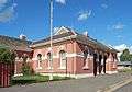 Post Office
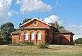 Court House
 Anglican Church
 Catholic Church
 Presbyterian Church
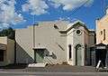 Mechanics Institute
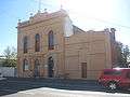 Charlie Napier Hotel

 War Memorial
References
- ↑ Australian Bureau of Statistics (31 October 2012). "Inglewood (L) (Urban Centre/Locality)". 2011 Census QuickStats. Retrieved 31 January 2011.
- 1 2 3 4 5 Inglewood 150 Years of Gold Celebrations 2009, David Rose
- ↑ Premier Postal History, Post Office List, retrieved 2008-04-11
- ↑ Golf Select, Inglewood, retrieved 2009-05-11
- ↑ Blackburn Abeyasekere, Susan. "Blackburn, Maurice McCrae (1880–1944)". Australian Dictionary of Biography.
- ↑ Thompson, Roger C. "Tivey, Edwin (1866–1947)". Australian Dictionary of Biography.
- ↑ "Maj-General E. Tivey dies at 81". The Argus. 1947-05-20. p. 7. Retrieved 2015-09-12.
External links
![]() Media related to Inglewood, Victoria at Wikimedia Commons
Media related to Inglewood, Victoria at Wikimedia Commons