Inexpressible Island
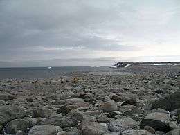 A view over Inexpressible Island | |
 Inexpressible Island Location in Antarctica | |
| Geography | |
|---|---|
| Location | Antarctica |
| Coordinates | 74°54′S 163°39′E / 74.900°S 163.650°ECoordinates: 74°54′S 163°39′E / 74.900°S 163.650°E |
| Administration | |
|
None | |
| Demographics | |
| Population | Uninhabited |
| Additional information | |
| Administered under the Antarctic Treaty System | |
Inexpressible Island is a small, rocky island in Terra Nova Bay, Victoria Land, Antarctica.
History
Robert Falcon Scott's Terra Nova Expedition (1910-1913) comprised several groups. One of these, the Northern Party, led by Victor Campbell, did not accompany Scott into the interior but wintered at Cape Adare. In 1912, that group (composed of six men in total), began the long journey homewards and began making their way to Cape Evans (via Hut Point). However, they were dropped at Evans Coves with sledging provisions for six weeks with the intention of completing geological work. After the work was done they were left with rations for about four weeks, as it was not anticipated the ship would have trouble picking them up later in February. But the Terra Nova could not reach them due to heavy pack ice.[1]:xlii Unable to connect with their ship, the Northern Party was forced to winter in Antarctica again. In March 1912 the party excavated a small 3.7 by 2.7 metres (12 by 9 ft) ice cave in a snow drift they nicknamed "Inexpressible Island" where they spent the winter in miserable conditions, supplementing their rations by killing scarce seal and penguins for meat.
The Northern Party had previously built a supply depot at Hells Gate Moraine (74° 52'S, 163° 50'E) on Inexpressible Island as a form of security should the Terra Nova be unable to collect them. The depot primarily consisted of a sledge loaded with supplies and equipment. Despite the fact that this depot had been built, the winter spent in the ice cave and a partially constructed rock shelter on Inexpressible Island was miserable. The men suffered frostbite, hunger, dysentery, and the abominable winds on the island. As ship doctor George Murray Levick said:[1]:xlv
| “ | "The road to hell might be paved with good intentions, but it seemed probable that hell itself would be paved something after the style of Inexpressible Island." | ” |
The men started home for Hut Point on September 30, 1912, some two hundred miles down the coast, which would include the crossing of the Drygalski Ice Tongue. Browning was very ill and Dickason almost crippled by dysentery. They reached Hut Point on November 5.[1]:xlviii
Historic site
The site of the ice cave where Victor Campbell's Northern Party wintered has been designated a Historic Site or Monument (HSM 14), following a proposal by New Zealand to the Antarctic Treaty Consultative Meeting. A wooden sign, a plaque and seal bones remain at the site.[2]

See also
- Composite Antarctic Gazetteer
- List of Antarctic and sub-Antarctic islands
- List of Antarctic islands south of 60° S
- SCAR
- Territorial claims in Antarctica
References
- 1 2 3 Apsley Cherry-Garrard, The Worst Journey in the World, Carrol & Graf, 1922.
- ↑ "List of Historic Sites and Monuments approved by the ATCM (2012)" (PDF). Antarctic Treaty Secretariat. 2012. Retrieved 2013-10-26.
External links
| Wikimedia Commons has media related to: |
- Antarctic Historic Sites
- Historic Huts in the Antarctic from the Heroic era (International Polar Heritage Committee)
![]() This article incorporates public domain material from the United States Geological Survey document "Inexpressible Island" (content from the Geographic Names Information System).
This article incorporates public domain material from the United States Geological Survey document "Inexpressible Island" (content from the Geographic Names Information System).