Indwe
| Indwe | |
|---|---|
|
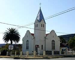
Reformed Church in Indwe | |
 Indwe  Indwe  Indwe
| |
| Coordinates: 31°27′58″S 27°19′59″E / 31.466°S 27.333°ECoordinates: 31°27′58″S 27°19′59″E / 31.466°S 27.333°E | |
| Country | South Africa |
| Province | Eastern Cape |
| District | Chris Hani |
| Municipality | Emalahleni |
| Established | 1896 |
| Area[1] | |
| • Total | 20.8 km2 (8.0 sq mi) |
| Population (2011)[1] | |
| • Total | 7,934 |
| • Density | 380/km2 (990/sq mi) |
| Racial makeup (2011)[1] | |
| • Black African | 95.7% |
| • Coloured | 3.0% |
| • Indian/Asian | 0.2% |
| • White | 0.8% |
| • Other | 0.4% |
| First languages (2011)[1] | |
| • Xhosa | 91.8% |
| • Afrikaans | 3.6% |
| • English | 1.8% |
| • Other | 2.8% |
| Postal code (street) | 5445 |
| PO box | 5445 |
| Area code | 045 |
Indwe is a town in Chris Hani District Municipality in the Eastern Cape province of South Africa.
The town is situated between Dordrecht and Elliot on the R56 road. It was founded in 1896 as a centre for coal-mining activities which started in 1867, and attained municipal status in 1898. It takes its name from the Indwe River, named after the blue crane (Anthropoides paradiseus, Xhosa: iNdwe), which occurred there in great numbers.[2]
History
Indwe was the fourth town after Johannesburg, Cape Town and Kimberley to have electricity. The “Indwe Railway Collieries and Land Company” was formed in Kimberley in late 1894. De Beers played a big part in it. The railway line was completed in March 1896. By 1899 the mine produced well over 100 000 tons of coal a year. By 1917 the coal mine closed down because meanwhile better quality coal had been discovered in the Transvaal.
References
Municipalities and communities of Chris Hani District Municipality, Eastern Cape | ||
|---|---|---|
District seat: Queenstown | ||
| Intsika Yethu | .svg.png) | |
| Enoch Mgijima | ||
| Engcobo | ||
| Emalahleni | ||
| Inxuba Yethemba | ||
| Sakhisizwe | ||