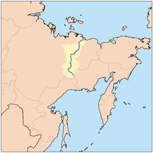
Indigirka River
| Indigirka River | |
|---|---|
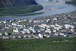 At Ust-Nera | |
 | |
| Country | Russia |
| Basin | |
| River mouth | East Siberian Sea |
| Basin size | 360,400 km2 (139,200 sq mi) |
| Physical characteristics | |
| Length | 1,726 km (1,072 mi) |
| Discharge |
|
The Indigirka River (Russian: Индиги́рка; Yakut: Индигиир) is a river in the Sakha Republic in Russia between the Yana River and the Kolyma River. It is 1,726 kilometres (1,072 mi) long. The area of its basin is 360,000 square kilometres (140,000 sq mi). The river flows into the Kolyma Bay, East Siberian Sea. It freezes up in October and stays under the ice until May–June.
Tributaries
The main tributaries are the:
- Kuydusun River
- Kyuente River
- Elgi River
- Nera River,
- Moma River
- Badyarikha River
- Selennyakh River
- Uyandina
Ports, settlements and economy
Main ports on the river are:
- Khonuu
- Druzhina
- Chokurdakh
- Tabor.
There is a gold prospecting industry in the Indigirka basin. Ust-Nera, a gold-mining center, is the largest settlement on the river.
The Indigirka River teems with a variety of fishes. Among the most valuable are several whitefish species, such as vendace, chir, muksun, inconnu (nelma), omul, etc.
History
The isolated village of Russkoye Ustye, located on the delta of the Indigirka, is known for the unique traditional culture of the Russian settlers whose ancestors came there several centuries ago. Some historians have speculated that Russkoye Ustye was settled by Pomors in the early 17th century.[1]
In 1638 Ivan Rebrov reached the Indigirka.[2] In 1636–42 Elisei Buza pioneered the overland route to the Indigirka river system. At about the same time, Poznik Ivanov ascended a tributary of the lower Lena, crossed the Verkhoyansk Range to the upper Yana and then crossed the Chersky Range to the Indigirka. In 1642 Mikhail Stadukhin reached the Indigirka overland from the Lena.[2]
Zashiversk on the Indigirka was an important colonial outpost during the early days of Russian colonization. It was subsequently abandoned in the 19th century. Other historical settlements, now long abandoned, were Podshiversk and Uyandinskoye Zimov'ye.
In 1892–94 Baron Eduard Von Toll carried out geological surveys in the basin of the Indigirka (among other Far-eastern Siberian rivers) on behalf of the Russian Academy of Sciences. During one year and two days the expedition covered 25,000 kilometres (16,000 mi), of which 4,200 kilometres (2,600 mi) were up rivers, carrying out geodesic surveys en route.
Mouths
The Indigirka forms a large delta, consisting of a number of streams (each one being labeled on Russian maps as a protoka (river arm)) and islands. About 100 kilometres (62 mi) before reaching the East Siberian Sea (70°48′45″N 148°54′58″E / 70.8126°N 148.9162°E), the river splits into two major northeast-flowing streams. The left (westernmost) arm is known as the Russko-Ustyinskaya Protoka; the right arm, the Srednyaya Protoka (Russian for the "Middle Arm"). Further downstream, the third major arm, the Kolymskaya Protoka splits off the Srednyaya Protoka as its right (eastern) distributary, thus justifying the "middle" moniker for the Srednyaya Protoka.[3]
While Srednyaya Protoka means the "Middle Arm", the names of the main western and eastern arms indicate their relative location as well. The Kolymskaya Protoka, or Kolymskoye Ustye is the arm one located on the eastern side, i.e. the "Kolyma side" of the delta (the arm closest to the Kolyma, the eastern neighbor of the Indigirka). The Russko-Ustyinskaya Protoka, apparently known earlier as simply Russkoye Ustye [4] is the arm one located on the western side, i.e. the "Russian side" of the delta (meaning, the side closest to the (European) Russia). These days the name of the Russko-Ustyinskaya Protoka appears as if it were formed from the name of the old Russian village Russkoye Ustye situated there, but originally the opposite is likely to have been the case, the village being named after the river arm (the Russkoye Ustye) on which it was located.
Several flat islands are formed by the channels of the delta. Listed from the east to the west, the major ones are:
- Usun-Ary 71°23′13″N 151°15′18″E / 71.387°N 151.255°E lies longitudinally along the coast east of the Srednyaya mouth. It is 12 kilometres (7 mi) and 2.7 kilometres (1.7 mi) wide.
- Uparovskiy Island 71°34′55″N 151°11′46″E / 71.582°N 151.196°E lies completely detached 11 kilometres (7 mi) offshore from the Srednyaya mouth. It is about 2 kilometres (1.2 mi) long and 1 km wide.
- Ploskiy Island 71°28′48″N 150°53′24″E / 71.480°N 150.890°E is the farthest offshore of a cluster of islands at the Srednyaya mouth. It is C-shaped and about 3 km long.
- Bolshoy Fedorovskiy 71°31′59″N 150°30′36″E / 71.533°N 150.510°E lies between the two mouths of the Indigirka. It is 6 km long and has a maximum width of 4 km.
- Vkodnoy and Oleniy islands lie right at the Prot. Russko Ust'inskaya mouth 71°32′46″N 150°15′58″E / 71.546°N 150.266°E. Both are of similar size, about 4 km in length.
- Krestovyy Island 71°26′49″N 149°45′58″E / 71.447°N 149.766°E lies quiet isolated directly to the south of the Lopatka Peninsula, 10 kilometres (6 mi) offshore to the northwest of the main Indigirka mouths. It is 6 km long and 1.6 km wide.
References
- ↑ Tatyana Bratkova "Russkoye Ustye". Novy Mir, 1998, no. 4 (Russian)
- 1 2 Lantzeff, George V., and Richard A. Pierce (1973). Eastward to Empire: Exploration and Conquest on the Russian Open Frontier, to 1750. Montreal: McGill-Queen's U.P.
- ↑ Indigirka in the Great Soviet Encyclopedia. (Russian)
- ↑ Indigirka in Brockhaus and Efron Encyclopedic Dictionary
- Indigirka at GEOnet Names Server
- Location of islands
- William Barr, Baron Eduard Von Toll's Last Expedition. Arctic, Sept 1980.
Coordinates: 70°48′N 148°54′E / 70.800°N 148.900°E