Indiana State Road 238
| ||||
|---|---|---|---|---|
|
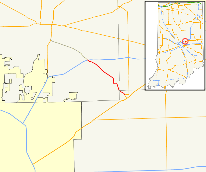
Former SR 238 (Eastern) in red; Western in Light Gray | ||||
| Route information | ||||
| Maintained by INDOT | ||||
| Length: | 10.41 mi[1] (16.75 km) | |||
| Existed: | 1980s – 2010s | |||
| Major junctions | ||||
| West end: |
| |||
| East end: |
| |||
| Location | ||||
| Counties: | Hamilton, Hancock, Madison | |||
| Highway system | ||||
| ||||

State Road 238 (SR 238) was a short 6 miles (9.7 km) stretch of two-lane undivided road, mostly in Hamilton County, that traveled southeast from near Fishers (a northeast suburb of Indianapolis) to Fortville. The western portion was concurrent with Greenfield Avenue.
Route description
SR 238 heads southeast from the interchange with Interstate 69, heading toward Fortville. In Fortville, SR 238 enters town on Merrill Street and turns onto Michigan Street. At the intersection of Michigan Street and Main Street in Fortville is the eastern terminus of SR 238 at State Road 13.[2]
History
SR 238 connected Fortville and its western terminus at SR 37 in Noblesville.[3]
Major intersections
| County | Location | mi[1] | km | Destinations | Notes | |||
|---|---|---|---|---|---|---|---|---|
| Hamilton | Fall Creek Township | 0.00 | 0.00 | Western terminus of SR 238 | ||||
| Madison |
No major junctions | |||||||
| Hancock | Fortville | 10.41 | 16.75 | Eastern terminus of SR 238 | ||||
| 1.000 mi = 1.609 km; 1.000 km = 0.621 mi | ||||||||
References
- 1 2 "INDOT Roadway Referencing System" (PDF). staff.
- ↑ Google (2011-01-27). "overview map of SR 238" (Map). Google Maps. Google. Retrieved 2011-01-27.
- ↑ Indiana Highway Ends - SR 238
External links
This article is issued from Wikipedia - version of the 11/15/2016. The text is available under the Creative Commons Attribution/Share Alike but additional terms may apply for the media files.