Indiana Dunes State Park
| Indiana Dunes State Park | |
|---|---|
 Location of State Park in Indiana | |
| Type | State Park; National Natural Landmark |
| Location | Porter County, Indiana, United States |
| Nearest city | Chesterton, Indiana |
| Coordinates | 41°40′N 87°02′W / 41.66°N 87.04°WCoordinates: 41°40′N 87°02′W / 41.66°N 87.04°W |
| Area | 2,182 acres (883 ha) |
| Created | 1925 |
| Operated by | Indiana Department of Natural Resources |
| Status | Open all year |
| Website | Official Website |
Indiana Dunes State Park is an Indiana State Park located 47 miles (75.6 km) east of Chicago, Illinois, United States. The park is bounded by Lake Michigan to the northwest, and is surrounded on all four sides by the Indiana Dunes National Lakeshore, a unit of the National Park Service (the National Lakeshore owns the water from the ordinary high water mark to 300 feet offshore[1]). The 1,530 acres (619.2 ha) Dunes Nature Preserve makes up the bulk of eastern part of the park, and includes most of the park’s hiking trails and dune landscape. This was one of the first places Richard Lieber considered when establishing the Indiana State Park system. Like all Indiana state parks, there is a fee for entrance. It was designated a National Natural Landmark in 1974.[2]
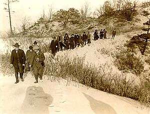
Preserving the Indiana Dunes has resulted from the efforts of many citizens and politicians.[3][4]
Geology
The beaches were formed by winds coming off Lake Michigan, which drop sand when the wind hits plants, dunes, and hills. As the lake level of Lake Michigan dropped at the end of the Ice Age, the shoreline receded, and new dunes were formed along the lakeshore. Vegetation took over the previous dunes, and eventually forests grew on top of them. There are "blowouts" along the dunes, where dead stumps were revealed after the wind blew away the sand from on top of them; the most notable such blowout is Big Blowout.
History
Native Americans used the area for years, primarily the Potawatomi and Miami people. The Dunes were along trade routes used by Native Americans. In the early 19th century, the state park area was home to the settlements of Petit Fort and City West.
Notable attractions

- Sand dunes
- Singing sand
- Smelt Fishing
- Haunted Shores (Diana of the Dunes)
- Birding
- hiking
Facilities and activities
- Swimming and Sunbathing A small portion of the shoreline is set aside as a public swimming beach and is protected by lifeguards between Memorial and Labor Day weekends. It is a clean, all sand beach. The remainder of the beach (approximately 2 miles (3.2 km)) is open for sunbathing, beach combing, and other similar activities. Dogs are permitted on the non-swimming portion of the beach, so long as they are kept on a short leash and any feces is promptly and safely removed from the shores.
- Beach house with concessions during summer season.[5]
- Observation platform near the top of Mt. Tom. Looking west, Chicago can be seen above the forested sand dunes. Gary, Indiana, is also visible.
- Birdwatching (A bird observation tower is located along Trail 10 overlooking a marsh community.)[5]
- Nature Center The Nature Center is a year-round facility that has a wildlife observation window, library, and a large auditorium. The exhibits were recently updated, so everything is brand new! An interpretive naturalist provides public hikes and programs.
- Picnic Shelters[5]
- Hiking trails 16 miles (26 km), some of which pass not only the sand dunes, but historic structures and wet prairie.[5]
- Guided Hiking Tours
- Cycling is not permitted everywhere within the park, but the Calumet Trail runs through the park and provides both cycling opportunities as well as access to the Indiana Dunes National Lakeshore as well as to some neighboring communities.
- Interpretive Naturalist Service
- Arts and crafts
- Camping The campground was totally rebuilt in 2004. It has 140 roomy campsites laid out on sand with new, level, asphalt paved pads, 50 amp electrical hook-ups, picnic tables. Drinking water hydrants are located throughout the campground. The roads are newly laid out and paved in 2004, arranged in several connecting loops. The smoothly paved loops of roadway lend themselves to bicycling, rollerblading, etc. Most of the trees were spared during the rebuilding so that many sites have full or partial shade. There are two, large, newly built shower house/restroom structures. There is a short, level forest path to the swimming beach.
Dunes Nature Preserve
| Dunes Nature Preserve | |
|---|---|
| Designated | 1974 |
The Nature Preserve covers the eastern 2/3 of the State Park, 1,530 acres (620 ha). It is accessible only on foot. All eight of the park's trails enter the nature preserve, offering easy to rugged experiences amongst the dunes. The highlights of the preserve include:[5]
- The Tremonts, Mt. Tom,192 feet (59 m) above lake level; Mt. Holden, 184 feet (56 m) above lake level; and Mt. Jackson 176 feet (54 m) above lake level.
- Beach House Blowout and Furnessville Blowout.[5]
- the Marsh with Bird Observation Tower.[5]
- Trails[5]
- Trail 8 takes you up and over all three of the high dunes. It's only 1.5 miles (2.4 km) long from the Wilson Shelter, over the high dunes, ending on the beach at the Pavilion and Beach House.
- Trail 10 is the longest 5.5 miles (8.9 km), but among the easier, listed as Moderate trails. It begins at the Pavilion and Bathhouse, traveling east along the open beach. About 1.25 miles (2.01 km) down the beach, you come to the Beach House Blowout. An additional 0.5 miles (0.80 km) and you reach the Furnessville Blowout. About half way, you come to the eastern boundary of the park and swing up into the dunes through an area called Paradise Valley. From there, the trail parallels a branch of the Dunes Creek, passing through the Pinery and along the marsh. The Bird Observation Tower is accessible from this trail. About 0.75 miles (1.21 km) from the Observation Tower, the trail ends at the Nature Center.
Designated a National Natural Landmark in 1974, the preserve also contains Ancient Pines Nature Area, a prehistoric forest now exposed by dune blowouts.[6]
Blowouts
Blowouts are formed by the on-shore winds of Lake Michigan. The winds move sand and pile it into dunes. As the dunes form, plants begin to take hold, stabilizing the sand. Beach grasses form a large underground system of roots. This root system, creates stable areas of sand, from which the dune can grow. Slowly other plants take root in the protected areas, including bearberry (kinnikinnick) and small evergreens. Over time, larger plants like sumac, sand cherry, cottonwood, and juniper take hold and replace the grasses and smaller plants.
When a nick forms in this armor of roots and plants, the area can become a blowout. First, open sand becomes accessible to the wind. This can be by animal trails or by human footpaths. A tree could fall in a strong wind, exposing the underlying sand. When this happens, the wind once again goes to work on the loose sand. It undercuts the other roots, and begins moving sand southward. If the winds are strong enough or given enough time, a large blowout can occur, reducing the dunes to lake level over a large area. The 3 largest blowouts in the park are Beach House, Furnessville, and Big Blowout. Each extends into the interdunes, between the front rides of dunes and pockets, into the interdunal troughs. Big Blowout has uncovered an area of dead tree trunks known as the Tree Graveyard.[7]
The park also has a Youth Tent Area separate from the public campground.
Gallery
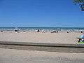 Beach view from the bathhouse on a nice sunny day.
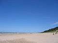 Miles of beautiful sand beach.
 Climb a dune
 There are seven trails through the park. Although short, trail #8 leads to the tops of the three highest dunes, the 'Tremonts'
 Bathhouse.
 On good days, you can often see Chicago across Lake Michigan, about 35 miles away.
See also
- Cross-country skiing
- Sand Trapping
- Sledding
- List of Indiana state parks
References
- ↑ National Park Service, "Indiana Dunes National Lakeshore and the Lake Michigan Shoreline: National Park Service Jurisdiction and Authorities on the Shore", October 2012.
- ↑ National Park Service: National Natural Landmark Program (Indiana) Retrieved 4 December 2014
- ↑ Smith, S. & Mark, S. (2006). Alice Gray, Dorothy Buell, and Naomi Svihla: Preservationists of Ogden Dunes. The South Shore Journal, 1.http://www.southshorejournal.org/index.php/issues/volume-1-2006/78-journals/vol-1-2006/117-alice-gray-dorothy-buell-and-naomi-svihla-preservationists-of-ogden-dunes
- ↑ Smith, S. & Mark, S. (2009). The Historical Roots of the Nature Conservancy in the Northwest Indiana/Chicagoland Region: From Science to Preservation. The South Shore Journal, 3. http://www.southshorejournal.org/index.php/issues/volume-3-2009/83-journals/vol-3-2009/75-the-historical-roots-of-the-nature-conservancy-in-the-northwest-indianachicagoland-region-from-science-to-preservation
- 1 2 3 4 5 6 7 8 Indiana Dunes State Park, Department of Natural Resources, Chesterton, Indiana.
- ↑ National Registry of Natural Landmarks (June 2009) p. 36. Retrieved 3 December 2014.
- ↑ Indiana Department of Natural Resources: Dunes Nature Preserve
External links
| Wikimedia Commons has media related to Indiana Dunes National Lakeshore. |
| Wikimedia Commons has media related to Indiana Dunes State Park. |
- Indiana Dunes State Park DNR Site
- Dunes Nature Preserve Indiana DNR Site
- The Prairie Club
- Save the Dunes Council
- Friends of the Indiana Dunes
- Duneland.com
- Dunes Learning Center