Indian Head River
| Indian Head River | |
|---|---|
|
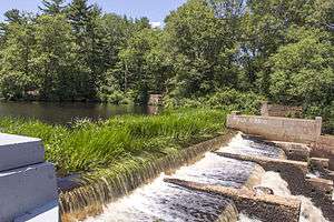
The dam and fish ladder at the Indian Head River reservoir. | |
| Basin | |
| River mouth | 3 ft (0.91 m) |
| Physical characteristics | |
| Length | 3.7 mi (6.0 km) |
The Indian Head River is located on the Hanover, Pembroke border in Massachusetts, United States, and covers about 8 acres (32,000 m2). The river, 3.7 miles (6.0 km) long,[1][2] is a tributary of the North River, which flows into Massachusetts Bay. The Indian Head River was probably a fishing and travel spot for Wompatuck Indians.
History
The river runs through the Luddams Ford Park, named after a guide, James Luddam, who in 1632 carried Governor Winthrop across the river to get to Weymouth. In November 1873, Eugene H. Clapp bought the Old Forge Property from George Curtis and built the Clapp Rubber Factory on the river.
Habitat
The factory is no longer there, but the mercury pollution from the factory still clings to the rocks and fish making it unsafe to drink the water and eat the fish. There is a strip of rubber along the river on the Pembroke side which people may bounce on.
The river now has a man-made dam and fish ladder. The river is stocked with trout. It also has a small beaver (Castor canadensis) population. For two weeks during the summer, the herring run up stream to spawn. If herring are caught they must be released and no motor boats are allowed. Once a year, the Hanover Police hold a free fishing derby for anybody that has a fishing license and a fishing rod.
There is a plaque that is embedded in the wall on a bridge that crosses the river. The plaque says:
"The Bay Path at Luddam's Ford across the Indian Head River the boundary line between _____ Hanover
1632 Gov. Winthrop crossed here on the back of James Luddam, his Guide.
Site of Saw Mill 1693
Bardin Iron Works 1704
Curtis Anchor Works 1791
Pembroke
Anchor for the Warship Constitution made here in 1797
A Grist Mill 1832
Carding Mill 1839
Clapp Rubber Co. 1873"
| Wikimedia Commons has media related to Indian Head River. |
References
- ↑ U.S. Geological Survey. National Hydrography Dataset high-resolution flowline data. The National Map Archived 2012-04-05 at WebCite, accessed April 1, 2011
- ↑ "Indian Head River". Geographic Names Information System. United States Geological Survey.
Coordinates: 42°05′46″N 70°50′46″W / 42.096°N 70.846°W