Iloilo Strait
| Iloilo Strait | |
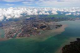 Aerial view of the Iloilo Strait with Guimaras in the bottom right and Iloilo City in the center, showing the mouth of the Iloilo River. | |
| Country | Philippines |
|---|---|
| Region | Western Visayas |
| Coordinates | PH 10°42′N 122°36′E / 10.700°N 122.600°ECoordinates: PH 10°42′N 122°36′E / 10.700°N 122.600°E |
| Length | 25 km (16 mi), NE-SW |
 | |

The Iloilo Strait is a strait in the Philippines that separates the islands of Panay and Guimaras in the Visayas, and connects the Panay Gulf with the Guimaras Strait. It is the location of the Port of Iloilo, the third busiest of the ports in the Philippines in number of ships.[1] Iloilo City on Panay is the major city located on the strait with Buenavista and Jordan, both on Guimaras, immediately across the strait from the city. The Iloilo River empties into the strait.
Pumpboat ferries cross every few minutes from Iloilo City to Guimaras and vice versa. Ships doing business with the Port of Iloilo often moor in the strait.
History
The Port of Iloilo was opened for international trade in 1855 and the coming of British Vice-consul Nicholas Loney, a year later, led to the fast development of the sugar industry in the region.[2]
Incidents
2GO Travel's ferry St. Gregory The Great nearly capsized on 15 June 2013, when it struck rocks under the water near the Siete Picados Islands.[3]
See also
References
- ↑ "PMO ILOILO". Philippine Ports Authority. Retrieved 15 July 2013.
- ↑ "History of Iloilo". Iloilo Provincial Government. 7 September 2011. Retrieved 15 July 2013.
- ↑ "Ship nearly capsizes in Iloilo Strait; passengers safe". Sun Star Iloilo. June 15, 2013. Retrieved 24 June 2013.
External links
-
 Media related to Iloilo Strait at Wikimedia Commons
 - Philippine Ports Authority
Seas of the Philippines | ||
|---|---|---|
| Ocean |  | |
| Sea | ||
| Strait |
| |
| Gulf | ||
See also: Bodies of water of the Philippines | ||